 geo.be Metadata Catalog
2026
Type of resources
Available actions
Topics
INSPIRE themes
federalThemes
Keywords
Contact for the resource
Provided by
Years
Formats
Representation types
Update frequencies
status
Service types
Scale
Resolution
-
The Royal Decree of 20 March 2026 establishing the marine spatial plan for the period 2026 to 2034 in the Belgian marine areas defines 3 aquaculture zones: Fisheries research zone (Art. 17§2), Zone accessible to aquaculture and passive fisheries (Art. 18), Zone accessible to aquaculture (Art. 18§1). It replaces the 2020 Marine Spatial Plan. Please refer to the Belgian official gazette ("Moniteur belgeBelgisch Staatsblad") for official reference information.
-
The Royal Decree of 20 March 2026 establishing the marine spatial plan for the period 2026 to 2034 in the Belgian marine areas defines 1 coastal protection experiments zone: Coastal protection belt (Art. 20§2). It replaces the 2020 Marine Spatial Plan. Please refer to the Belgian official gazette ("Moniteur belgeBelgisch Staatsblad") for official reference information.
-
The Royal Decree of 20 March 2026 establishing the marine spatial plan for the period 2026 to 2034 in the Belgian marine areas defines 1 commercial and industrial zones: Zone C for commercial and industrial activities (Art. 27§1). It replaces the 2020 Marine Spatial Plan. Please refer to the Belgian official gazette ("Moniteur belgeBelgisch Staatsblad") for official reference information.
-
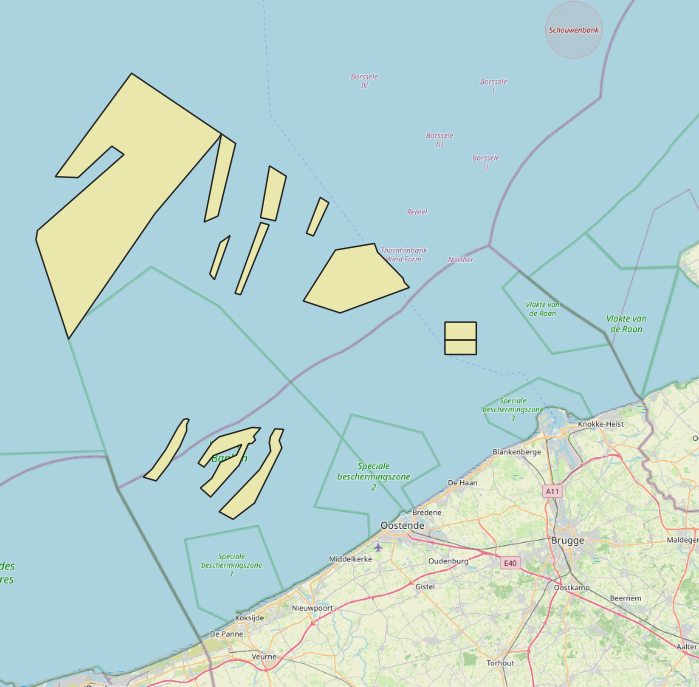
The Royal Decree of 20 March 2026 establishing the marine spatial plan for the period 2026 to 2034 in the Belgian marine areas defines 13 dredging zones: Dredge spoil disposal zone S1 (Art. 15§1.1°), Dredge spoil disposal zone S2 (Art. 15§1.2°), Dredge spoil disposal zone "Public Works Ostend" (Art. 15§1.3°), Dredge spoil disposal zone "Public Works Zeebrugge East" (Art. 15§1.4°), Dredge spoil disposal zone "Public Works Zeebrugge West" (Art. 15§1.5°), Dredge spoil disposal site "Public Works Nieuwpoort" (Art. 15§1.6°), Dredge spoil disposal zone "Zeebrugge Erosion Pit" (Art. 15§1.7°), Zone 1 for future replacement of dredge spoil zone S1 (Art. 15§4.1°), Zone 2 for future replacement of dredge spoil zone S1 (Art. 15§4.2°), Search zone 1 for future replacement of Zeebrugge East and West (Art. 15§6), Search zone 2 for future replacement of Zeebrugge East and West (Art. 15§6), Search zone 3 for future replacement of Zeebrugge East and West (Art. 15§6), Dredge spoil disposal zone for future replacement "Public Works Nieuwpoort" (Art. 15§8). It replaces the 2020 Marine Spatial Plan. Please refer to the Belgian official gazette ("Moniteur belgeBelgisch Staatsblad") for official reference information.
-
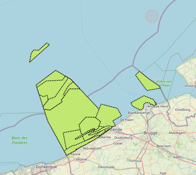
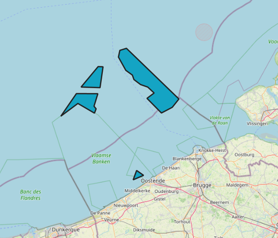
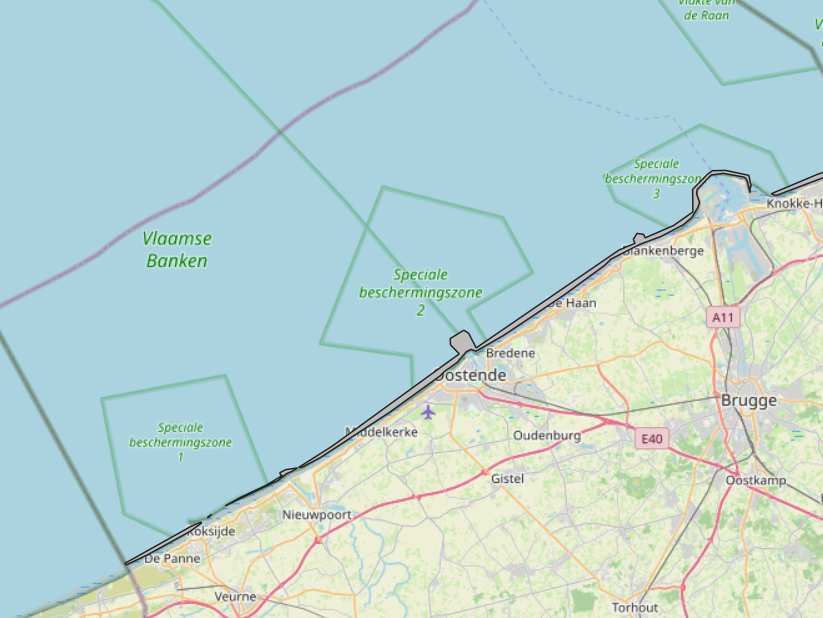
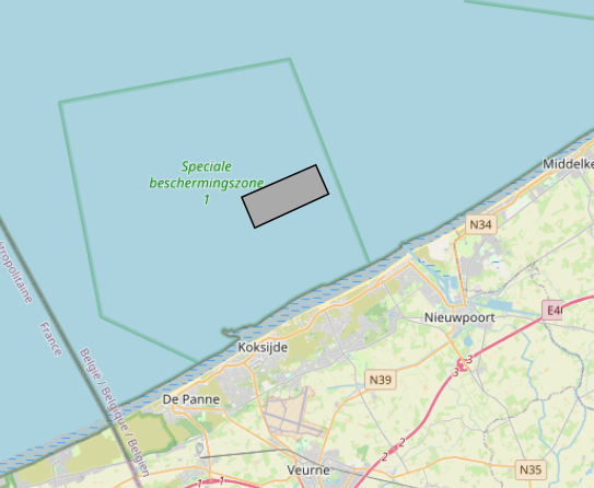
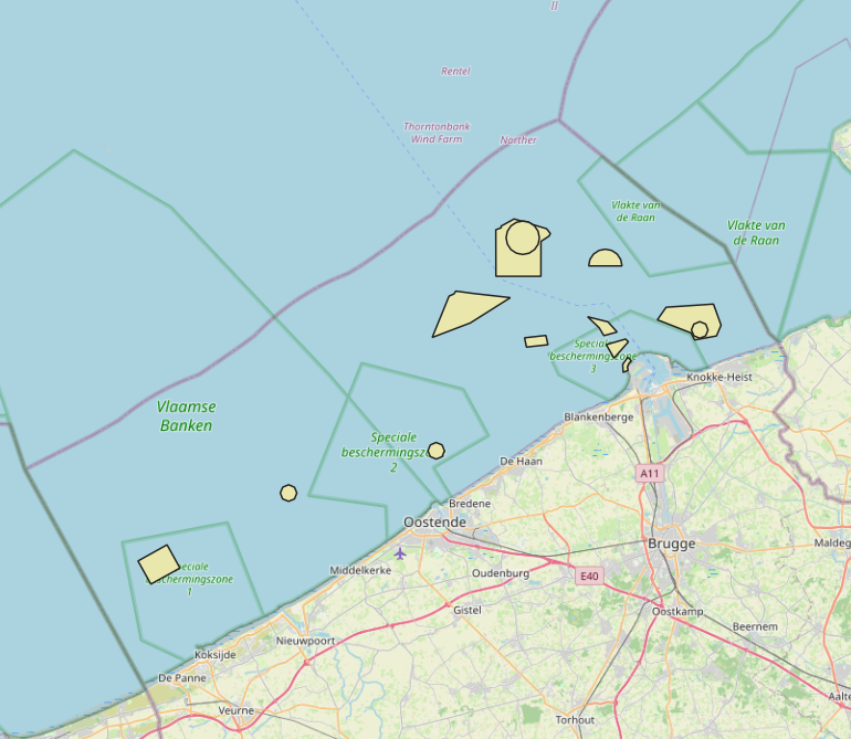
The Royal Decree of 20 March 2026 establishing the marine spatial plan for the period 2026 to 2034 in the Belgian marine areas defines 13 nature conservation areas: Seabed integrity zone: Zone 1, upper (Art. 10§1.1°), Seabed integrity zone: Zone 2, middle (Art. 10§1.2°), Seabed integrity zone: Zone 3, lower (Art. 10§1.3°), Ramsar area (Art. 11), Special Area of Conservation "Vlaamse Banken" (Art. 8§1), Special Area of Conservation "Vlakte van de Raan" (Art. 8§3), Special Protection Area for Birds: SPA 1 (Art. 8§5.1°), Special Protection Area for Birds: SPA 2 (Art. 8§5.2°), Special Protection Area for Birds: SPA 3 (Art. 8§5.3°), Marine reserve: Zone 1, upper (Art. 9§1.1°), Marine reserve: Zone 2a, middle (Art. 9§1.2°), Marine reserve: Zone 2b, middle (Art. 9§2), Marine reserve: Zone 3, lower (Art. 9§3). It replaces the 2020 Marine Spatial Plan. Please refer to the Belgian official gazette ("Moniteur belgeBelgisch Staatsblad") for official reference information.
-
The law of 13 June 1969 defines “Belgian Continental Shelf” as follows: the seabed and the subsoil of the marine areas adjacent to the Belgian coast but beyond the Belgian territorial sea.
-
The Royal Decree of 20 March 2026 establishing the marine spatial plan for the period 2026 to 2034 in the Belgian marine areas defines 8 scientific research and recreation zones: Thorntonbank monitoring area (Art. 23§10.1°), Gootebank monitoring area (Art. 23§10.2°), Scientific research zone (Art. 23§3), Search area for scientific research reserve (Art. 23§6), Zone with prohibition of additional fixed structures (Art. 23§7.4°), Zone accessible for scientific research 1 (Art. 23§8.1°), Zone accessible for scientific research 2 (Art. 23§8.1°), Reference area for calibration and quality assessment of measuring instruments (Art. 23§9). It replaces the 2020 Marine Spatial Plan. Please refer to the Belgian official gazette ("Moniteur belgeBelgisch Staatsblad") for official reference information.
-
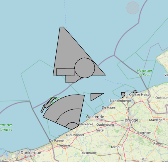
The Royal Decree of 20 March 2026 establishing the marine spatial plan for the period 2026 to 2034 in the Belgian marine areas defines 13 military use zones: Mine warfare exercise zone – QZR 040 (Art. 21§1.1°), Mine warfare exercise zone – NBH-10 (Wenduine) (Art. 21§1.2°), Mine warfare exercise zone – NB-01 (Westhinder) (Art. 21§1.3°), Mine warfare exercise zone (Buiten Ratel) (Art. 21§1.4°), Belgisch Nationaal Oefengebied voor Marineschepen (BNOM) (Art. 21§1.5°), Shallow Water Zone (Art. 21§1.6°), Zone for detonation exercises and operations (Art. 21§2), Lombardsijde firing sector: small sector (Art. 21§3.1°), Lombardsijde firing sector: middle sector (Art. 21§3.2°), Lombardsijde firing sector: large sector (Art. 21§3.3°), Paardenmarkt munitions disposal site (Art. 22§1). It replaces the 2020 Marine Spatial Plan. Please refer to the Belgian official gazette ("Moniteur belgeBelgisch Staatsblad") for official reference information.
-
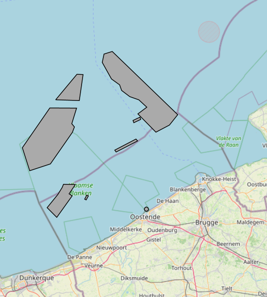
The Royal Decree of 20 March 2026 establishing the marine spatial plan for the period 2026 to 2034 in the Belgian marine areas defines 12 sand and gravel extraction zones: Sand and gravel extraction sector 1a (Thorntonbank) (Art. 19§1.1°), Sand and gravel extraction sector 4d (Art. 19§1.10°), Sand and gravel extraction sector 5 (Blighbank) (Art. 19§1.11°), Sand extraction sector 2kb (Kwintebank) (Art. 19§1.2°), Sand extraction sector 2br (Buiten Ratel) (Art. 19§1.3°), Sand extraction sector 2od (Oostdyck) (Art. 19§1.4°), Sand and gravel extraction sector 3a (Sierra Ventana) (Art. 19§1.5°), Sand and gravel extraction sector 3b (Sierra Ventana) (Art. 19§1.6°), Sand and gravel extraction sector 4a (Noordhinder) (Art. 19§1.7°), Sand and gravel extraction sector 4b (Oosthinder North) (Art. 19§1.8°), Sand and gravel extraction sector 4c (Oosthinder South) (Art. 19§1.9°), Extraction search zone (Art. 19§4). It replaces the 2020 Marine Spatial Plan. Please refer to the Belgian official gazette ("Moniteur belgeBelgisch Staatsblad") for official reference information.
-
UNDER EMBARGO - This dataset originates from the BE/2023 sampling campaign conducted in southwest Greenland fjords (Igaliku and Tunulliarfik) and quantifies grazing impacts by micro- and mesozooplankton on phytoplankton and heterotrophic microbial communities (including bacteria) in two fjord systems characterized by contrasting glacial regimes. Grazing and microbial growth rates were estimated using two-point dilution experiments (two-point dilution experiments), alongside experiments assessing mesozooplankton and copepod grazing on both phytoplankton and microzooplankton. Community responses were resolved using imaging flow cytometry, enabling the identification of plankton functional groups (autotrophic, mixotrophic, and heterotrophic) and size classes. The dataset also includes measurements of chlorophyll a variability determined by high-performance liquid chromatography. Overall, the dataset supports analyses of trophic interactions and grazing dynamics across the microbial food web under differing glacier-influenced environmental conditions.