 geo.be Metadata Catalog
notPlanned
Type of resources
Available actions
Topics
INSPIRE themes
federalThemes
Keywords
Contact for the resource
Provided by
Years
Formats
Representation types
Update frequencies
status
Service types
Scale
Resolution
-

This dataset contains the orthophoto mosaics that were created following the floods of July 2021 in the valleys of the Vesdre, the Meuse and the Demer. Orthophotos are aerial photographs that have been geometrically corrected (orthorectified) to eliminate distortions caused by terrain relief, lens distortion, and camera tilt. Unlike raw aerial imagery, orthophotos have a uniform scale and accurate geometry, making them suitable for cartography, measurements, and visual analysis. This specific dataset includes orthophotos based on aerial photographs acquired in July 2021 by Hansa Luftbild, commissioned by the National Geographic Institute (NGI), following the floods in the zones of the Vesdre, a part of the Meuse downstream of Liège and the Demer. The resulting orthophoto mosaics are georeferenced in the Lambert 2008 coordinate system. All orthophotos are in colour (RGB). The ground resolution (GSD) is 6.5 cm (4 cm above the Hoëgne). The spatial coverage of this dataset is limited to the affected zones. The data can be visualized via the corresponding web service (WMS). The data is available on request via https://ngi.be/aanbod/kaarten-en-fotos/luchtfotos-orthofotos/.
-
Network of marks whose planimetric coordinates are known with precision according to the reference systems which are used in Belgium.
-

The data set contains a seamless polygonal layer representing the land cover in Belgium for the year 2018. The dataset is INSPIRE compliant.
-

Landcover100Map is a digital version of the NGI’s topographic cartography on a scale of 1 :100 000. The images come from the symbolisation of the objects and the themes in the topo-geographic inventory of the Belgian territory (ITGI), which is built and kept up-to-date by the NGI. Landcover100Map is meant for a regional use on a larger scale than the one for Top50Map, typically on the scale of a province. The land use theme is very salient in this topographic cartography. The relief is represented by shadowing.
-

The INSPIRE contour lines used for a cartographic representation of the relief at scale 1:50000, a product of the National Geographic Institute in Belgium. The dataset features are in accordance with the INSPIRE specifications.
-
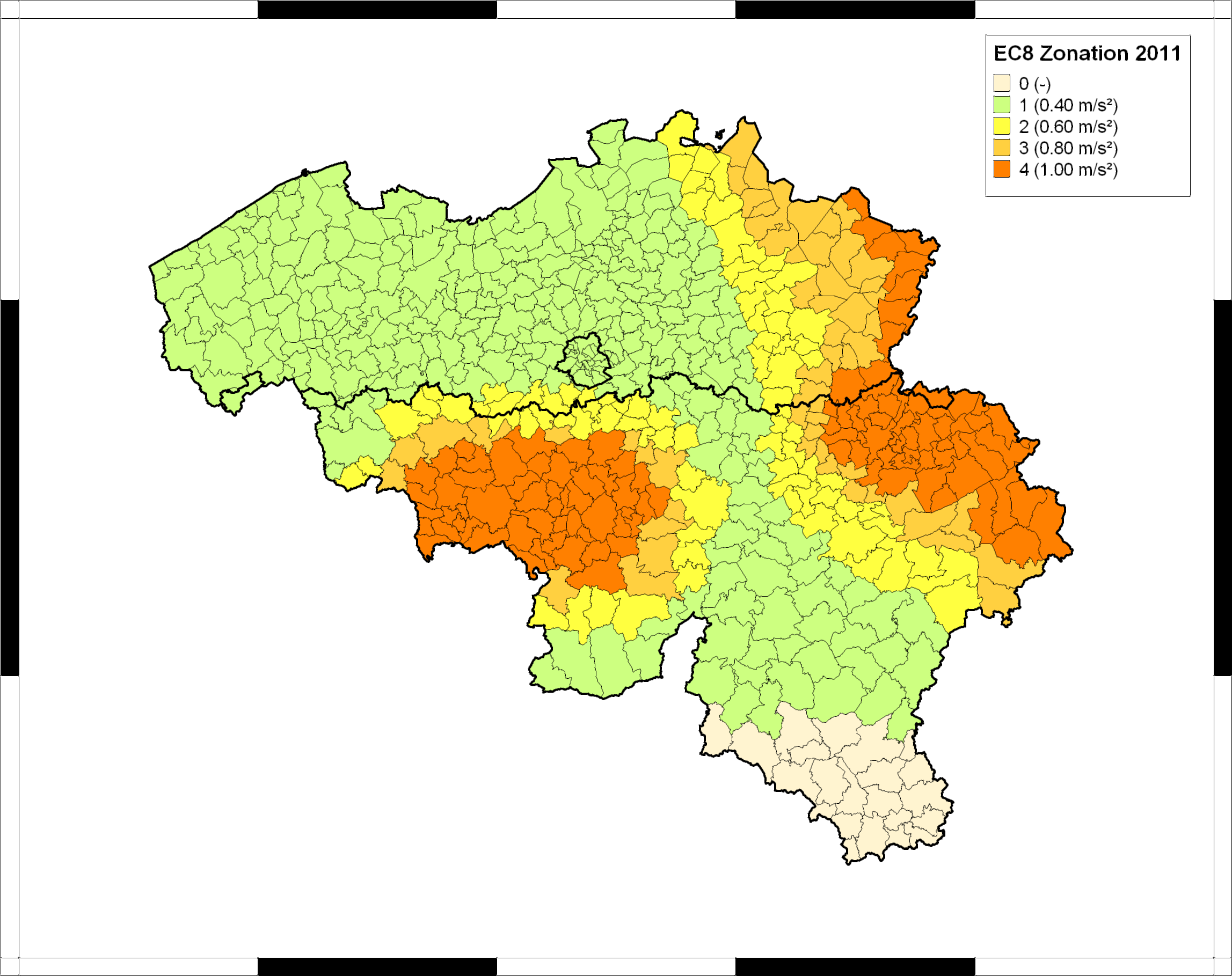
The seismic zoning map for Belgium was published in the Belgian national annex (NBN EN 1998-1 ANB) to the European building code Eurocode 8 (EN 1998-1), which became effective in all European member states in 2011. This map classifies Belgian communes into five seismic zones, corresponding to different values of the reference peak ground acceleration (PGA) to be taken into account in the design of structures for earthquake resistance. In combination with the importance class of the building and the ground type, the reference PGA is used to calculate the design response spectrum defining the accelerations that the structure should be able to withstand without collapse. For further details and the precise specifications, users should consult the normative documents, which can be ordered from the Bureau for Standardisation NBN (https://www.nbn.be/en). The Eurocode-8 seismic zoning map for Belgium was established by the Royal Observatory of Belgium, based on a reimplementation of the seismic hazard map of Leynaud et al. (2000) for a return period of 475 years (equivalent to 10% probability of exceedance in a timespan of 50 years). This hazard map was calculated following the principles of probabilistic seismic hazard assessment, and based on a simple model of seismic sources and their activity in and around Belgium, and a single ground-motion model (or “attenuation law”), describing PGA in function of earthquake magnitude and epicentral distance. To date, this is the only seismic hazard map that has been published specifically for Belgium, and it is still considered as the official seismic hazard map for Belgium.
-

The entities included in dataset represent the Belgian waterway transport network in the sense of the Inspire European directive. The dataset comprises several classes and is in accordance with the INSPIRE specifications. The class represents, in a linear manner, all of the waterway links between each pair of dots for the network considered. In addition to this is one class without geometry. The RestrictionForWaterCehicles class specifies for each segment the maximum tonnage of the building using the segment.
-

Buildings is the INSPIRE 2D vector data set of the "Constructions" layer originated from the Top10vector product of the National Geographic Institute in Belgium . It includes the "Building" features and the "OtherConstruction" features in accordance with the INSPIRE specifications.
-
The data set contains a seamless polygonal layer representing the land cover in Belgium for the year 2012 and the year 2018. The polygons are spread over 32 classes from the CORINE Land Cover legend which are present un Belgium. The minimum map unit is 25 ha. The conceptual scale is 1:100 000. The data set also contains a polygon layer showing changes of more than 5 ha in the land cover between 2012 and 2018.
-

This dataset shows a digital surface model. It is a homogeneous and regular points grid which indicates the height above the surface of the earth, either the soil or any other permanent and visible element in the landscape (vegetation, construction,…). These data represent the situation of the landscape resulting from the July 2021 floods in het areas of the Vesdre, of part of the Meuse downstream from Liège and of the Demer.