 geo.be Metadata Catalog
CSV
Type of resources
Available actions
Topics
INSPIRE themes
federalThemes
Keywords
Contact for the resource
Provided by
Years
Formats
Representation types
Update frequencies
status
Service types
Scale
Resolution
-
The climatological network contains about 200 stations spread over the whole country. It consists of voluntary observers recruited by the RMI, professional observers of Skeyes (civil aviation) or the Air Force (military aviation) and civil servants of the state, communities or private companies. The observers measure the amount of rain fallen in the last 24 hours in the pluviometer of the RMI every morning at 8 o‘clock. In more than half of the stations the extreme air temperatures are also recorded by reading the maximum and minimum temperature in a standardized weather shelter. The observers send their observations either on a daily or on a monthly basis to RMI. This product is not publicly available yet.
-

Settlement area is defined here in terms of land use. Settelement area is the space occupy to live, work, relax and move around. This includes everything that seals the soil but also includes various forms of non-paved green space, such as gardens and parks or sports grounds and these are therefore not counted as open space. These indicators show the total settelement area expressed in m² and the part of the settlement area in relation to the total area per administrative entity (region, province, district and municipality) for Flanders.
-
Total of undeveloped aera en de part of undeveloped aera in relation to the total surface - Flanders
The areas not included in the settelement area considered to be categories of open space. However, open space should not be confused with green or undeveloped space. The settelement area also includes various forms of non-paved green space, such as gardens and parks or sports grounds and these are counted as developed area. These indicators show the total area of open space expressed in m² en de part of open area in relation to the total surface per administrative unit (region, province, district and municipality) for Flanders.
-
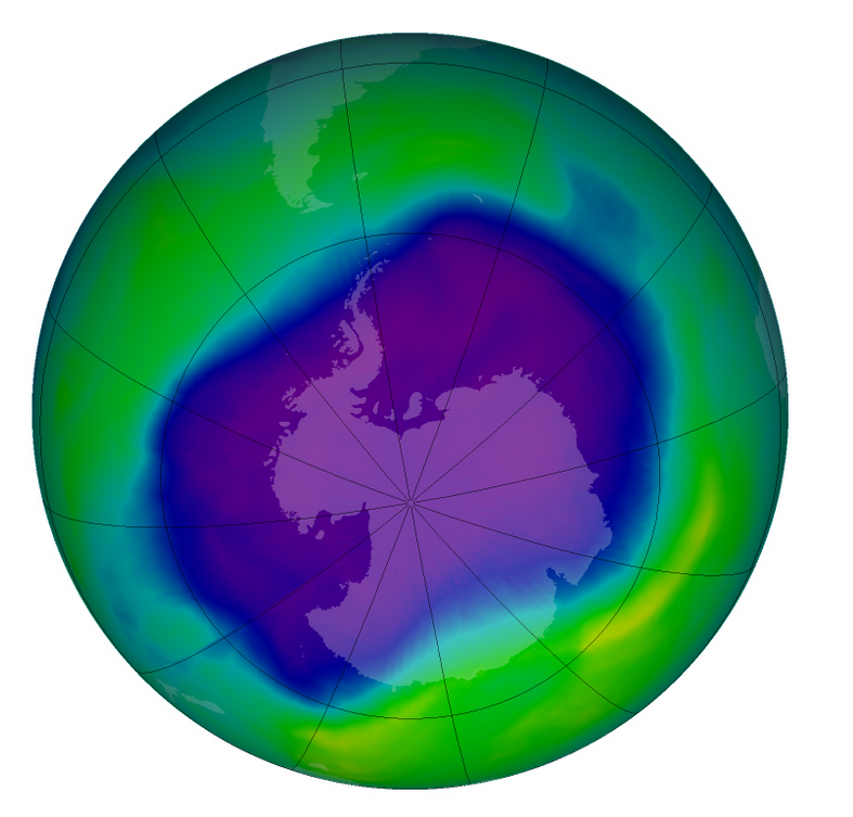
From multiple observations during the day with UV spectrophotometers a daily value of the ozone column is calculated. This product is not publically available yet.
-

Characteristics of the cadastral parcels - Rights of legal persons corresponds to the dataset describing the legal persons holding real rights on the parcels such as recorded by the FPS Finance for registration purposes. This dataset is composed of seven classes. The first class shows, at the national level, for each cadastral nature and for each type of real right, the number of parcels, their total cadastral income, as well as the number of parcels on which legal persons from the concerned NACE code hold the concerned real rights. The second class includes this information at the level of the three regions. The following classes do the same at the level of provinces, arrondissements, municipalities, cadastral divisions and statistical sectors. The dataset can be freely downloaded as a zipped CSV.
-
The localised unemployment rate calibrated on the labour force survey (LFS), by administrative unit (region, province, district and municipality) for Belgium.
-
Foreign real estate - Property characteristics corresponds to the dataset of foreign real estate held by belgian taxpayers as declared to the FPS Finance (only the holders of rights allowing the enjoyment of the property are taken into account). This dataset consists of one class. This class includes, for each foreign country or territory, the number of properties in each category, the total cadastral income of these properties, the median cadastral income of each category, as well as the 25 and 75 percentiles of the cadastral income of each category.
-
The ratio of the number of people aged over 80 to the number of people aged over 65 according to official statistics, per administrative entity (region, province, district and municipality) for Flanders
-
The ratio of the number of people aged over 80 to the number of people aged over 65 according to official statistics, per administrative entity (region, province, district and municipality) for Wallonia
-
Share of the cadastral surface area that is not artificially developed in the cadastral and not unknown surface area to the administrative entity (region, province, district and municipality) for Wallonia