 geo.be Metadata Catalog
2021
Type of resources
Available actions
Topics
INSPIRE themes
federalThemes
Keywords
Contact for the resource
Provided by
Years
Formats
Representation types
Update frequencies
status
Service types
Scale
Resolution
-
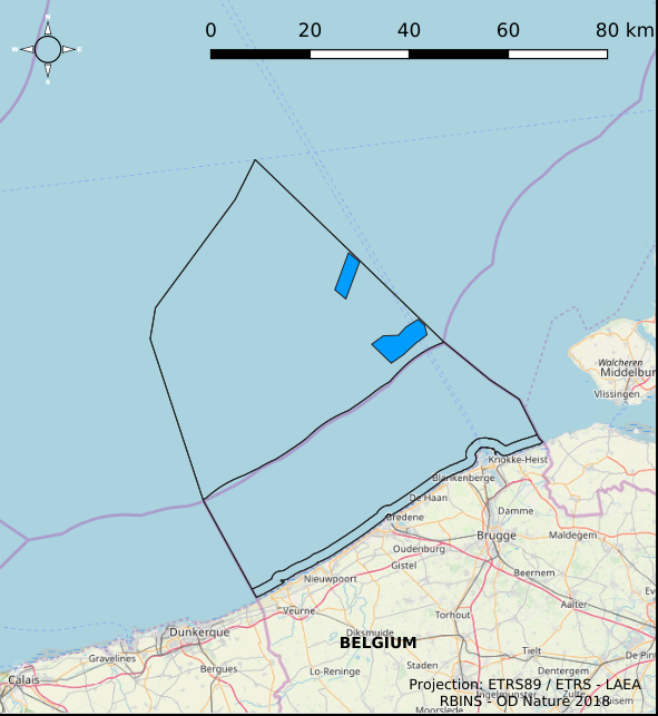
The Royal Decree of 22 May 2019 establishing a marine spatial plan defines 7 cultural heritage (wrecks) zones: 'HMS Briljant' wreck (Art. 22), 'SS Kilmore' wreck (Art. 22), '’t Vliegend Hart' wreck (Art. 22), 'U-11' wreck (Art. 22), 'West Hinder' wreck (Art. 22), Wooden wreck 'Oostende' (Art. 22), Wreck site 'Buiten Ratel' (Art. 22). Please refer to the Belgian official gazette (\"Moniteur belge/Belgisch Staatsblad\") for official reference information.
-

This dataset shows a digital surface model. It is a homogeneous and regular points grid which indicates the height above the surface of the earth, either the soil or any other permanent and visible element in the landscape (vegetation, construction,…). These data represent the situation of the landscape resulting from the July 2021 floods in het areas of the Vesdre, of part of the Meuse downstream from Liège and of the Demer.
-

The Royal Decree of 22 May 2019 establishing a marine spatial plan defines 5 nature conservation areas: Special area for conservation 'The Flemish Banks' (Art. 7§1), Special area for conservation 'Vlakte van de Raan' (Art. 7§3), Special protection area for birds - SPA 1 (Art. 7§5.1°), Special protection area for birds - SPA 2 (Art. 7§5.2°), Special protection area for birds - SPA 3 (Art. 7§5.3°). It replaces the 2014 Marine Spatial Plan, which is included for completeness. The Royal Decree of 20 March 2014 establishing a marine spatial plan defines in its Art. 7., six nature conservation sites: two special areas for conservation (Art. 7. §1, Special area for conservation 'Vlaamse Banken' and Art. 7. §3, Special area for conservation 'Trapegeer stroombank'), three special protection zones for birds (Art7§4.1°, SBZ1, Art7§4.2°, SBZ2, Art7§4.3°, SBZ3), and one marine reserve (Art7§8, Marine reserve 'Baai van Heist'). These zones are made available digitally in the resource described by this metadata document. Please refer to the Belgian official gazette (\"Moniteur belge/Belgisch Staatsblad\") for official reference information.
-

The Royal Decree of 22 May 2019 establishing a marine spatial plan defines 12 sand and gravel extraction zones: Sand and gravel exploitation sector 1a (Thorntonbank) (Art. 15§1), Sand and gravel exploitation sector 2br (Buiten Ratel) (Art. 15§1), Sand and gravel exploitation sector 2kb (Kwintebank) (Art. 15§1), Sand and gravel exploitation sector 2od (Oostdyck) (Art. 15§1), Sand and gravel exploitation sector 3a (Sierra Ventana) (Art. 15§1), Sand and gravel exploitation sector 3b (Sierra Ventana) (Art. 15§1), Sand and gravel exploitation sector 4a (Noordhinder) (Art. 15§1), Sand and gravel exploitation sector 4b (Oosthinder-noord) (Art. 15§1), Sand and gravel exploitation sector 4c (Oosthinder-zuid) (Art. 15§1), Sand and gravel exploitation sector 4d (Westhinder) (Art. 15§1), Sand and gravel exploitation sector 5 (Blighbank) (Art. 15§1), Zone for research of the potential of the exploration and exploitation of sand and gravel (Art. 15§4). It replaces the 2014 Marine Spatial Plan, which is included for completeness.. The Royal Decree of 20 March 2014 establishing a marine spatial plan defines in its Art. 11., eleven Management zones with regards to sand and gravel extraction: ten sand and gravel exploitation zones (Thorntonbank, Art. 11 § 1 Sector 1a, Kwintebank, Art. 11 § 1 Sector 2kb, Buiten Ratel, Art. 11 § 1 Sector 2br, Oostdyck, Art. 11 § 1 Sector 2od, Sierra Ventana, Art. 11 § 1 Sector 3a, Sierra Ventana, Art. 11 § 1 Sector 3b, Noord Hinder, Art. 11 § 1 Sector 4a, Oosthinder-noord, Art. 11 § 1 Sector 4b, Oosthinder-zuid, Art. 11 § 1 Sector 4c, Westhinder, Art. 11 § 1 Sector 4d) and one reference zone for monitoring impact of windmills and sand exploitation (Art. 11 § 3). These zones are made available digitally in the resource described by this metadata document. Please refer to the Belgian official gazette (\"Moniteur belge/Belgisch Staatsblad\") for official reference information.
-
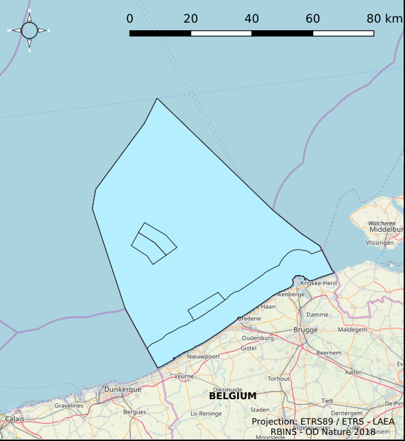
The Royal Decree of 22 May 2019 establishing a marine spatial plan defines 4 aquaculture zones: Zone 1 for aquaculture (Eastern zone) (Art. 14§1), Zone 2 for aquaculture (Noordhinder Noord) (Art. 14§2), Zone 3 for aquaculture (Noordhinder Zuid) (Art. 14§3), Zone 4 for aquaculture (Fairybank) (Art. 14§3). It replaces the 2014 Marine Spatial Plan, which is included for completeness. The Royal Decree of 20 March 2014 establishing a marine spatial plan defines in its Art. 10, two zones for sustainable aquaculture: Zone 1 for sustainable aquaculture, Art. 10 § 2 Zone 1; Zone 2 for sustainable aquaculture, Art. 10 § 2 Zone 2. These zones are made available digitally in the resource described by this metadata document. Please refer to the Belgian official gazette (\"Moniteur belge/Belgisch Staatsblad\") for official reference information.
-

The Royal Decree of 22 May 2019 establishing a marine spatial plan defines 11 military use and storage sites for war munition zones: Exercise area for sweeping mines (Buiten Ratel) (Art. 17§1), Exercise area for sweeping mines - NB-01 (Westhinder) (Art. 17§1), Exercise area for sweeping mines - NBH-10 (Wenduine) (Art. 17§1), Exercise area for sweeping mines - QZR 040 (Art. 17§1), Munition destruction area (Art. 17§2), Area for shooting exercises on floating objects (Art. 17§3), Area for exercises in shallow waters (Art. 17§4), Area for shooting exercises from land - big sector (Art. 17§5), Area for shooting exercises from land - medium sector (Art. 17§5), Area for shooting exercises from land - small sector (Art. 17§5), Storage site for war munition Paardenmarkt (Art. 18§1). It replaces the 2014 Marine Spatial Plan, which is included for completeness. The Royal Decree of 20 March 2014 establishing a marine spatial plan defines in its Art. 13. and Art. 14., resp. nine zones for military use and one storage site for war munition: three zones for shooting exercises from land direction sea (Art 13. § 1 small sector, Art 13. § 1 medium sector, Art 13. § 1 large sector), four exercise areas for sweeping mines (Art 13. § 3, Exercise area 1 for sweeping mines, Art 13. § 5, Exercise area 2 for sweeping mines, Art 13. § 9, Exercise area 3 for sweeping mines, Art 13. § 13, Exercise area 4 for sweeping mines), one area for shooting exercises on floating objects (Art 13. § 7), one area for defusing mines (Art 13. § 11) and one zone to safeguard the closed storage site for war munition \"Paardenmarkt\" (Art. 14. § 1). These zones are made available digitally in the resource described by this metadata document. Please refer to the Belgian official gazette (\"Moniteur belge/Belgisch Staatsblad\") for official reference information.
-
The Royal Decree of 22 May 2019 establishing a marine spatial plan defines 7 fishery management zones: Professional fisheries (Art. 13), Passive fisheries area (Noordhinder Noord) (Art. 14§4), Passive fisheries area (Noordhinder Zuid) (Art. 14§4), Passive fisheries (Fairybank) (Art. 14§4), Search area 1 for fisheries techniques (Art. 6§1), Search area 2 for fisheries techniques (Art. 6§1), Search area 3 for fisheries techniques (Art. 6§1). It replaces the 2014 Marine Spatial Plan, which is included for completeness. The Royal Decree of 20 March 2014 establishing a marine spatial plan defines in its Art. 6, six fisheries management areas: Regular regime, Art. 6 § 1; Fisheries management area 1, Art. 6 § 1.1°; Fisheries management area 2, Art. 6 § 1.2°; Fisheries management area 3, Art. 6 § 1.3°; Fisheries management area 4, Art. 6 § 1.4°; Fisheries management area 5, Art. 6 § 3. These zones are made available digitally in the resource described by this metadata document. Please refer to the Belgian official gazette (\"Moniteur belge/Belgisch Staatsblad\") for official reference information.
-
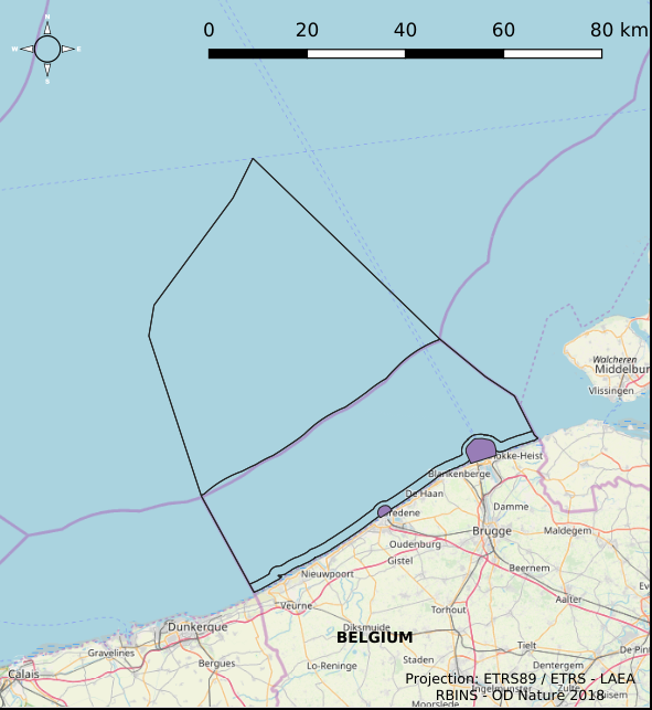
The Royal Decree of 22 May 2019 establishing a marine spatial plan defines 2 potential seaport expansion zones: Potential harbour extension Oostende (Art. 12§2), Potential harbour extension Zeebrugge (Art. 12§3). It replaces the 2014 Marine Spatial Plan, which is included for completeness. The Royal Decree of 20 March 2014 establishing a marine spatial plan defines in its Art. 9. § 10, two zones (Art. 9 §10 zone 1, Ostend, Art. 9 §10 zone 2, Zeebrugge) for the potential extension of the sea ports of Ostend en Zeebrugge. These zones are made available digitally in the resource described by this metadata document. Please refer to the Belgian official gazette (\"Moniteur belge/Belgisch Staatsblad\") for official reference information.
-

The number of inhabitants on January 1 according to the official definition of the population, by administrative entity (region, province, district and municipality) for Flanders and the Brussels Capital Region
-
Population density and area of administrative entities (region, province, district and municipality) for Flanders and the Brussels Capital Region