 geo.be Metadata Catalog
Location
Type of resources
Available actions
Topics
INSPIRE themes
federalThemes
Keywords
Contact for the resource
Provided by
Years
Formats
Representation types
Update frequencies
status
Scale
-

This dataset corresponds to the dataset of address points on the Belgian territory. The result is obtained by merging the three regions on the basis of XML files which has been supplied to BOSA for the cooperation agreement BeStAddress. The dataset is freely downloadable.
-
Points Of Interest - Cult elements contains point elements relating to the cult, namely churchs (anglican, catholic, orthodox, protestant), mosques, synanogues, buddhist temples, chapels, abbeys, priories and other religious buildings or small monuments in Belgium.
-

Geodetic markers of which the 3D coordinates are precisely known in common Belgian reference systems.
-
Network of marks whose planimetric coordinates are known with precision according to the reference systems which are used in Belgium.
-

This dataset contains the latest version of the borders of the Belgian postal codes, including the "special" postal codes (0612, 1049, 6099,…).
-

Points Of Interest - Natural elements contains point elements relating to nature, namely remarkable trees and underground cavities in Belgium.
-
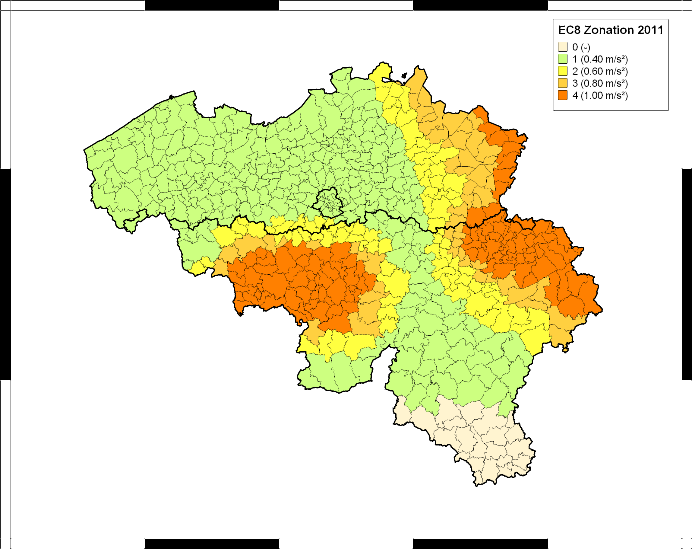
The seismic zoning map for Belgium was published in the Belgian national annex (NBN EN 1998-1 ANB) to the European building code Eurocode 8 (EN 1998-1), which became effective in all European member states in 2011. This map classifies Belgian communes into five seismic zones, corresponding to different values of the reference peak ground acceleration (PGA) to be taken into account in the design of structures for earthquake resistance. In combination with the importance class of the building and the ground type, the reference PGA is used to calculate the design response spectrum defining the accelerations that the structure should be able to withstand without collapse. For further details and the precise specifications, users should consult the normative documents, which can be ordered from the Bureau for Standardisation NBN (https://www.nbn.be/en). The Eurocode-8 seismic zoning map for Belgium was established by the Royal Observatory of Belgium, based on a reimplementation of the seismic hazard map of Leynaud et al. (2000) for a return period of 475 years (equivalent to 10% probability of exceedance in a timespan of 50 years). This hazard map was calculated following the principles of probabilistic seismic hazard assessment, and based on a simple model of seismic sources and their activity in and around Belgium, and a single ground-motion model (or “attenuation law”), describing PGA in function of earthquake magnitude and epicentral distance. To date, this is the only seismic hazard map that has been published specifically for Belgium, and it is still considered as the official seismic hazard map for Belgium.
-
Whole of marks whose height with respect to the zero mark of the second general leveling is known.
-
Points Of Interest - Economy interest contains point elements indicating the location of an economic activity, such as a brewery, wholesale market, (commercial, industrial) building, cooling tower, gas processing/disposal, slagheap, telecommunications, wind turbine, solar panel park in Belgium.
-
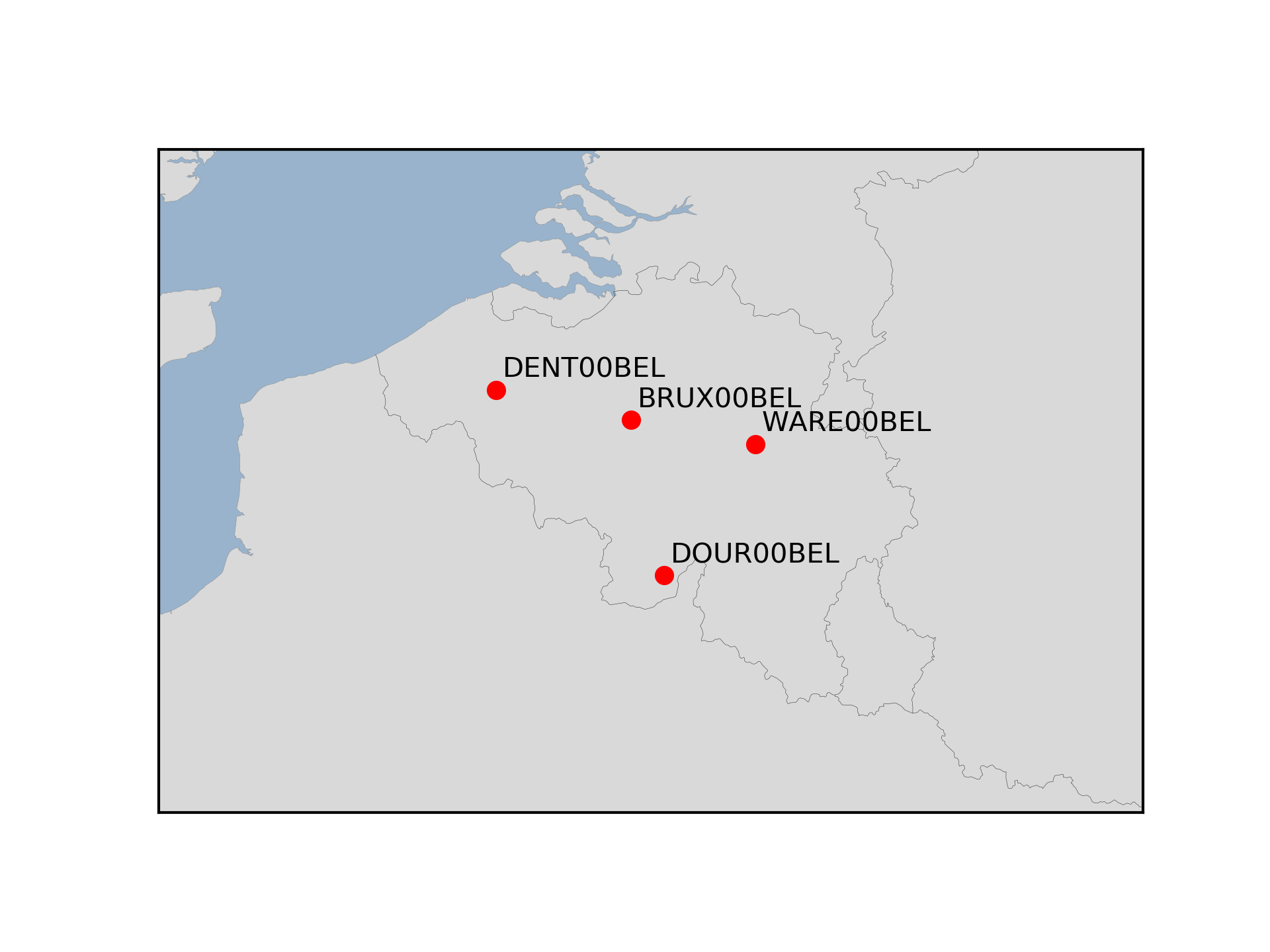
The Royal Observatory of Belgium maintains several continuously observing GNSS tracking stations in Belgium. The stations are also belonging to EUREF Permanent Network (EPN) used to maintain the ETRS89 and the observation data are available to the public through https://doi.org/10.24414/FST8-P256.