 geo.be Metadata Catalog
Land use
Type of resources
Available actions
Topics
INSPIRE themes
federalThemes
Keywords
Contact for the resource
Provided by
Years
Formats
Representation types
Update frequencies
status
Service types
Scale
Resolution
-

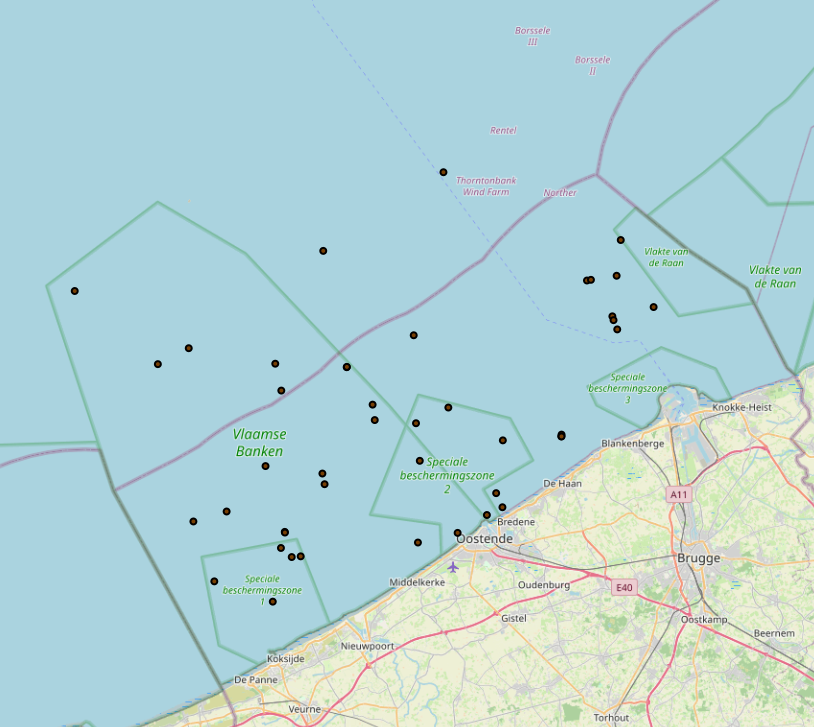
Points Of Interest - Natural elements contains point elements relating to nature, namely remarkable trees and underground cavities in Belgium.
-
2019 Belgian MSP - Princess Elizabeth Zone for renewable Energy in the Belgian Part of the North Sea
This dataset represents the location of the Princess Elizabeth zone in the Belgian Part of the North Sea as described in the Royal Decree of May 22th, 2019, establishing a marine spatial plan for the period 2020-2026. Art. 8. § 3.
-

Natura 2000 (N2K) is a network of core breeding and resting sites for rare and threatened species, as well as for some rare natural habitat types which are protected in their own right. It stretches across all 28 EU countries, both on land and at sea. The aim of the network is to ensure the long-term survival of Europe's most valuable and threatened species and habitats that are listed under the Birds Directive and the Habitats Directive. This dataset contains the sites in Belgium.
-

This web service allows viewing datasets from LandUse-Particular Zone
-

INSPIRE compliant view service for geographic information of the Marine Spatial Plan made available by the Royal Belgian Institute for Natural Sciences (RBINS).
-
INSPIRE compliant view service for geographic information of the Marine Spatial Plan made available by the Royal Belgian Institute for Natural Sciences (RBINS).
-
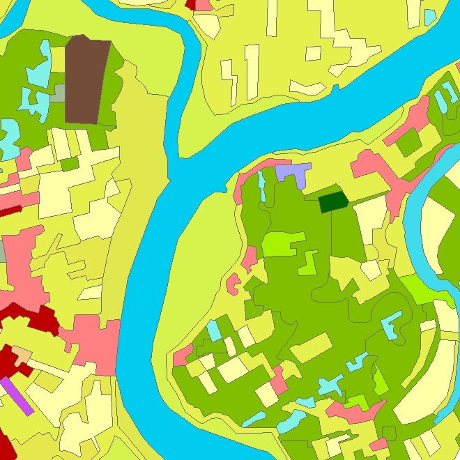
Riparian zones represent transitional areas occurring between land and freshwater ecosystems, characterised by distinctive hydrology, soil and biotic conditions and strongly influenced by the stream water. They provide a wide range of riparian functions (e.g. chemical filtration, flood control, bank stabilization, aquatic life and riparian wildlife support, etc.) and ecosystem services. The Riparian Zones products will support the objectives of several European legal acts and policy initiatives, such as the EU Biodiversity Strategy to 2020, the Habitats and Birds Directives and the Water Framework Directive. Two complementary product groups provide detailed information on the state and characteristics of riparian zones across Belgium: 1. Land Cover / Land Use (LCLU) 2. Green Linear Elements (GLE)
-
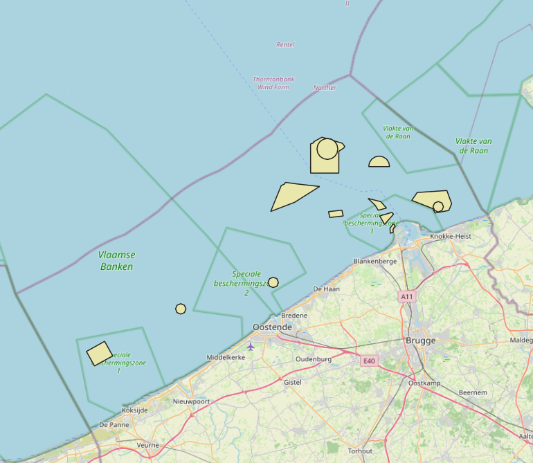
The Royal Decree of 20 March 2026 establishing the marine spatial plan for the period 2026 to 2034 in the Belgian marine areas defines 13 dredging zones: Dredge spoil disposal zone S1 (Art. 15§1.1°), Dredge spoil disposal zone S2 (Art. 15§1.2°), Dredge spoil disposal zone "Public Works Ostend" (Art. 15§1.3°), Dredge spoil disposal zone "Public Works Zeebrugge East" (Art. 15§1.4°), Dredge spoil disposal zone "Public Works Zeebrugge West" (Art. 15§1.5°), Dredge spoil disposal site "Public Works Nieuwpoort" (Art. 15§1.6°), Dredge spoil disposal zone "Zeebrugge Erosion Pit" (Art. 15§1.7°), Zone 1 for future replacement of dredge spoil zone S1 (Art. 15§4.1°), Zone 2 for future replacement of dredge spoil zone S1 (Art. 15§4.2°), Search zone 1 for future replacement of Zeebrugge East and West (Art. 15§6), Search zone 2 for future replacement of Zeebrugge East and West (Art. 15§6), Search zone 3 for future replacement of Zeebrugge East and West (Art. 15§6), Dredge spoil disposal zone for future replacement "Public Works Nieuwpoort" (Art. 15§8). It replaces the 2020 Marine Spatial Plan. Please refer to the Belgian official gazette ("Moniteur belgeBelgisch Staatsblad") for official reference information.
-
The Royal Decree of 20 March 2026 establishing the marine spatial plan for the period 2026 to 2034 in the Belgian marine areas defines 1 cultural heritage (wrecks) zones: Protected shipwrecks (Art. 26§1). It replaces the 2020 Marine Spatial Plan. Please refer to the Belgian official gazette ("Moniteur belgeBelgisch Staatsblad") for official reference information.
-

The Royal Decree of 22 May 2019 establishing a marine spatial plan defines in its Art. 11. five dredged material disposal sites (Dredged material disposal site S1, Art. 11 § 1.1°; Dredged material disposal site S2, Art. 11 § 1.2°; Dredged material disposal site Bruggen en Wegen Oostende, Art. 11 § 1.3°; Dredged material disposal site Bruggen en Wegen Zeebrugge Oost, Art. 11 § 1.4°; Dredged material disposal site Bruggen en Wegen Nieuwpoort, Art. 11 § 1.5°). Futhermore, additional zones are defined for the future replacement of dredging areas as defined in Art. 11 §3, §5, §7 and §9. It replaces the 2014 Marine Spatial Plan, which is included for completeness. The Royal Decree of 20 March 2014 establishing a marine spatial plan defines in its Art. 9. five dredged material disposal sites (Dredged material disposal site S1, Art. 9 § 6.1°; Dredged material disposal site S2, Art. 9 § 6.2°; Dredged material disposal site Bruggen en Wegen Oostende, Art. 9 § 6.3°; Dredged material disposal site Bruggen en Wegen Zeebrugge Oost, Art. 9 § 6.4°; Dredged material disposal site Bruggen en Wegen Nieuwpoort, Art. 9 § 6.5°). These zones are made available digitally in the resource described by this metadata document. Please refer to the Belgian official gazette (\"Moniteur belge/Belgisch Staatsblad\") for official reference information.