 geo.be Metadata Catalog
CSV
Type of resources
Available actions
Topics
INSPIRE themes
federalThemes
Keywords
Contact for the resource
Provided by
Years
Formats
Representation types
Update frequencies
status
Service types
Scale
Resolution
-

Notifications of the cadastral income corresponds to the dataset describing the new cadastral incomes of property located in Belgium that has been notified to the taxpayer. This dataset is made up of seven classes. The first class includes, at national level, by fiscal status, by nature of cadastral income and by category of motivations, the number of cadastral incomes notified, the total amount of cadastral incomes notified, the median cadastral income notified, the 25th and 75th percentiles of cadastral incomes notified and the standard deviation of cadastral incomes notified. The second class includes this information at the level of the three regions. The following classes do the same at the level of provinces, arrondissements, municipalities, cadastral divisions and statistical sectors. The dataset can be freely downloaded as a zipped CSV.
-

Distribution of real estate assets - Legal persons corresponds to the dataset relating to the distribution of real estate assets owned by legal entities such as recorded by the FPS Finance for tax purposes. This dataset is composed of eight classes. The first class mentions, at national level, for each cadastral income bracket, the number of legal persons grouped together by economic activity with real estate capital valued in the relevant bracket as well as the total and median cadastral income of the parcels held by these entities. The assessment of the cadastral income takes into account the shares actually held. The second class includes this information at the level of the three regions. The following classes do the same at the level of provinces, districts, municipalities, land register divisions and statistical sectors. The last class includes this information at the level of the countries for the legal entities which are not settled in Belgium but wich are nevertheless reigstred at the Carrefour Banque of the Entreprises. The dataset can be freely downloaded as a zipped CSV.
-
Foreign real estate - Owners' profile corresponds to the dataset describing the profile of Belgian taxpayers (natural persons) holding real estate abroad. This dataset is composed of five classes. The first shows, at national level, by age and sex category, the number of individuals holding a real right that allows enjoyment over foreign property, the total number of foreign properties held by these individuals, and the number of properties by foreign country or territory. The number of properties takes into account the shares actually held. The second class presents this information at the level of the three regions. The following classes do the same for provinces, arrondissements and communes. The dataset is freely downloadable as zipped CSV files.
-
Distribution of real estate assets - real estate companies corresponds to the dataset relating to the distribution of real estate assets owned by legal entities such as recorded by the FPS Finance for tax purposes. This dataset is composed of eight classes. The first class mentions, at national level, for each cadastral income bracket, the number of legal entities with real estate activity (that is to say, registered under the code L of NACE nomenclature) and with real estate capital valued in the relevant bracket as well as the total and median cadastral income of the parcels held by these entities. The assessment of the cadastral income takes into account the shares actually held. The second class includes this information at the level of the three regions. The following classes do the same at the level of provinces, districts, municipalities, land register divisions and statistical sectors. The last class includes this information at the level of the countries for the legal entities which are not settled in Belgium but wich are nevertheless reigstred at the Carrefour Banque of the Entreprises.The dataset can be freely downloaded as a zipped CSV.
-
Owner occupants corresponds to the dataset relating to persons domiciled in a property over which they, or a member of their family, exercise a right in rem such as recorded by the FPS Finance for registration purposes. This dataset is composed of seven classes. The first class mentions, at national level, for each age-gender combination, by type of right in rem, the number of natural persons having such a right on their home. The lack of right in rem corresponds here to a fictitious right in rem in order to identify individuals who do not have rights on their home. The second class includes this information at the level of the three regions. The following classes do the same at the level of provinces, districts, municipalities, land register divisions and statistical sectors. The dataset can be freely downloaded as a zipped CSV.
-
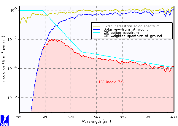
UV Index derived from spectral measurements with a Brewer UV spectrophotometer. This product is not publically available yet.
-

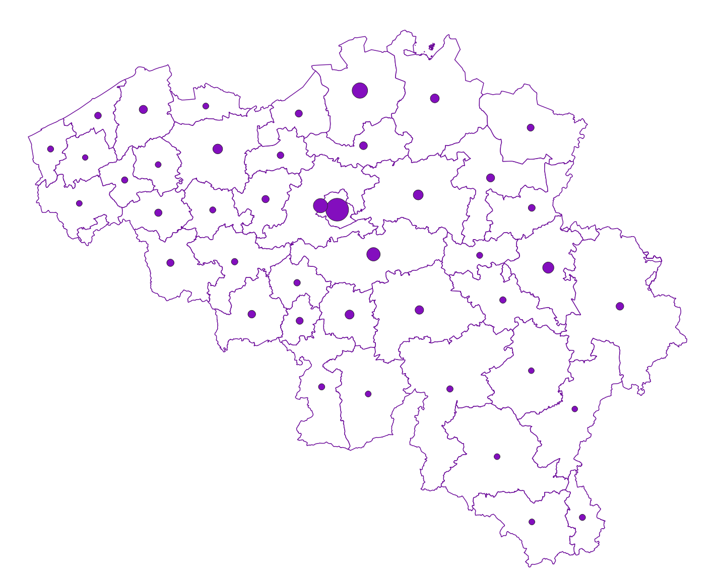
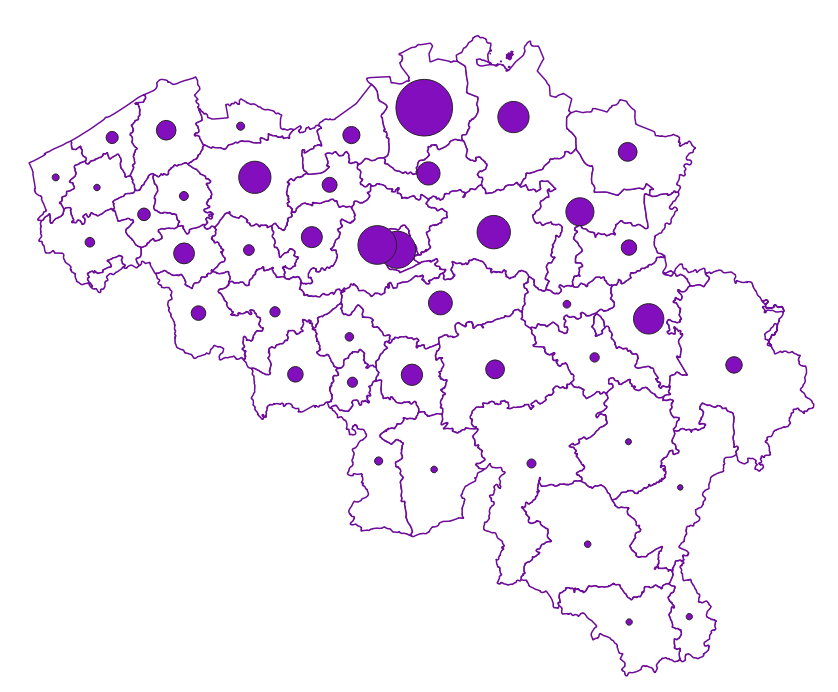
Share of the cadastral surface area that is artificially developed in the cadastral surface area and not unknown to the administrative entity (region, province, district and municipality) for Wallonia
-
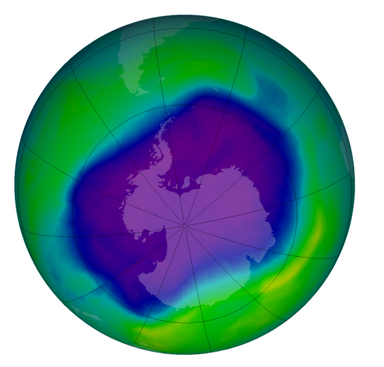
From multiple observations during the day with UV spectrophotometers a daily value of the ozone column is calculated. This product is not publically available yet.
-

Real estate leases corresponds to the dataset describing leases on real estate items as recorded for registration purposes by the FPS Finance. This dataset is composed of seven classes. The first class shows, at the national level, for each type of lease within the meaning of the Code of Registration Duties, the number of leases taking effects during the term, the nature of the parties concerned by the contract and the median rent and expenses and the percentiles 25 and 75 of the rent and expenses of the properties concerned. The second class includes this information at the level of the three regions. The following classes do the same at the level of provinces, arrondissements, municipalities, cadastral divisions and statistical sectors. The dataset can be freely downloaded as a zipped CSV.
-
The climatological network contains about 200 stations spread over the whole country. It consists of voluntary observers recruited by the RMI, professional observers of Skeyes (civil aviation) or the Air Force (military aviation) and civil servants of the state, communities or private companies. The observers measure the amount of rain fallen in the last 24 hours in the pluviometer of the RMI every morning at 8 o‘clock. In more than half of the stations the extreme air temperatures are also recorded by reading the maximum and minimum temperature in a standardized weather shelter. The observers send their observations either on a daily or on a monthly basis to RMI. This product is not publicly available yet.