 geo.be Metadata Catalog
Royal Belgian Institute for Natural Sciences (RBINS)
Type of resources
Available actions
Topics
INSPIRE themes
federalThemes
Keywords
Contact for the resource
Provided by
Years
Formats
Representation types
Update frequencies
Service types
Scale
-

This web service allows viewing the datasets under the Marine Strategy Framework Directive (MSFD).
-
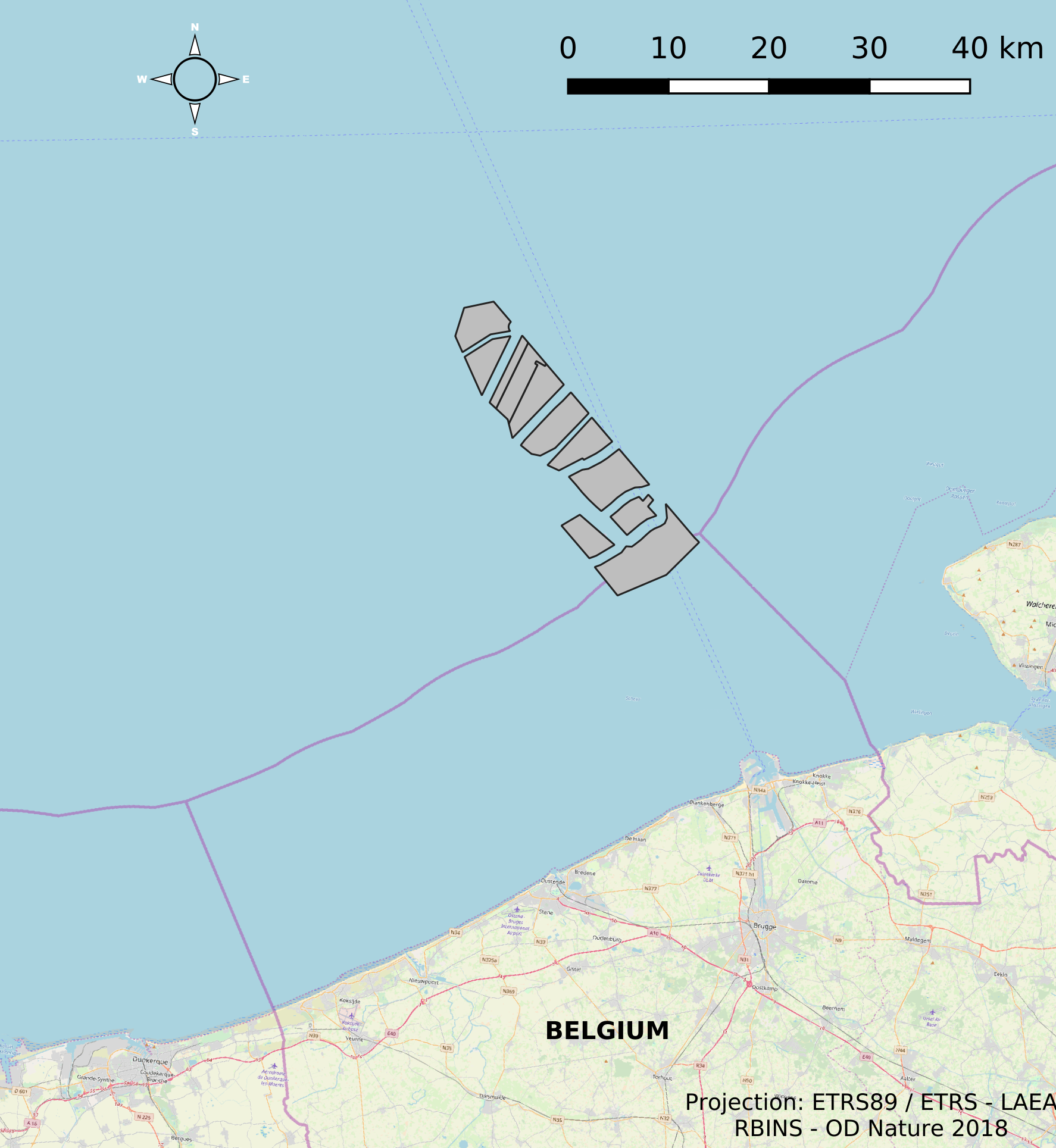
This dataset represents the location of the windfarms concessions in the Belgian Part of the North Sea.
-

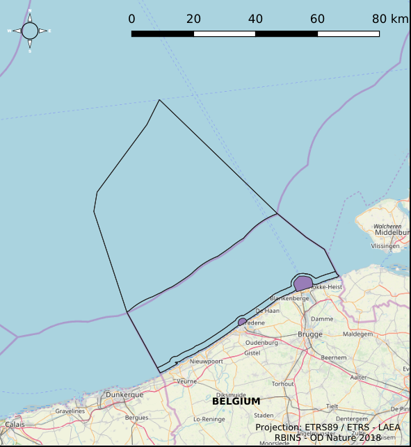
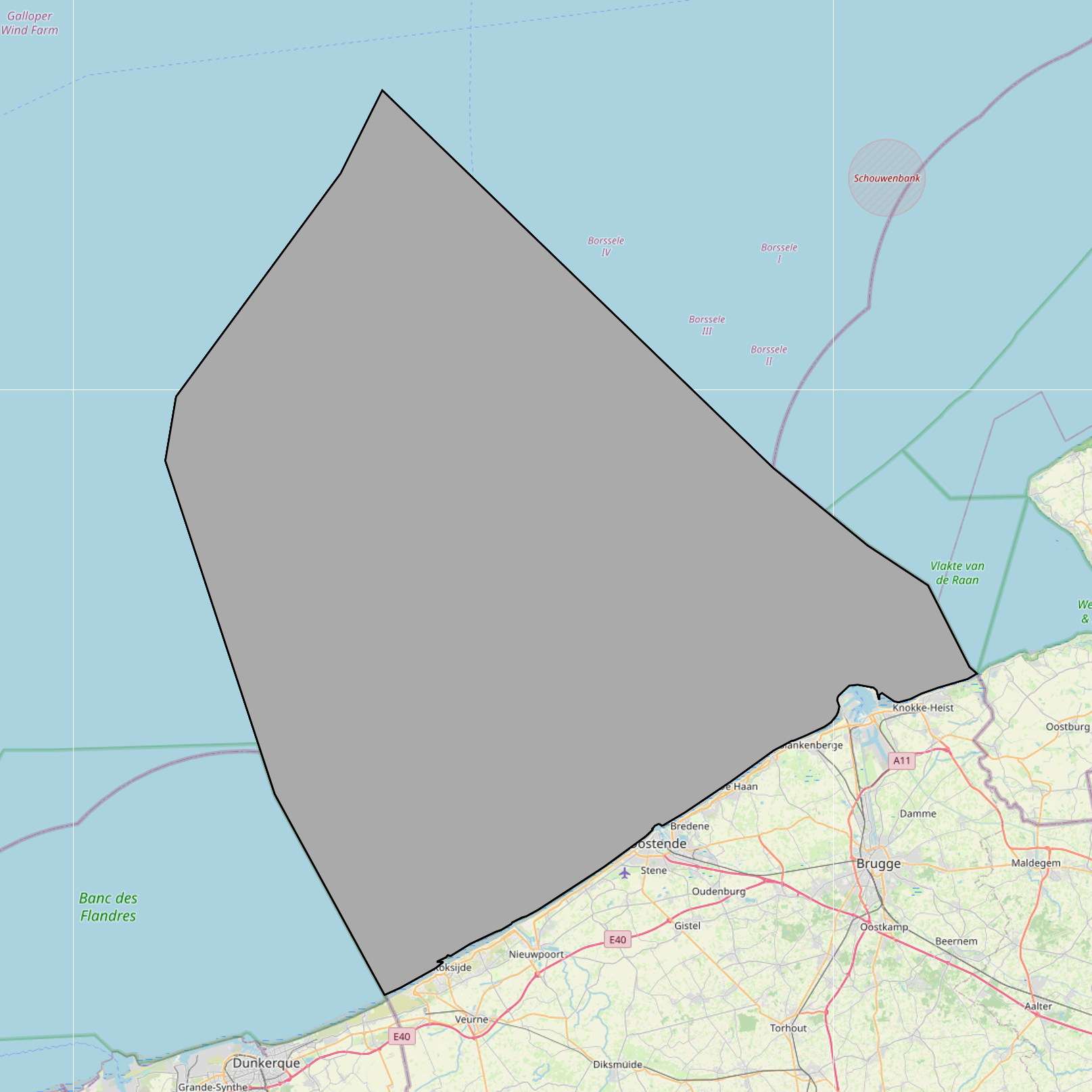
The Royal Decree of 22 May 2019 establishing a marine spatial plan defines 20 shipping and ports zones: Shipping regular regime (Art. 10§1), Northbound traffic flow starting at separation line 'Noordhinder Sud' (Art. 10§2.1°), Separation zone 'Noordhinder Sud' (Art. 10§2.1°), Precaution zone 'Near Thornton and Blighbank ' (Art. 10§2.10°), Northbound traffic flow starting at separation zone 'Off Noordhinder' (Art. 10§2.2°), Separation zone 'Off Noordhinder' (Art. 10§2.2°), Southbound traffic flow starting at separation line 'Off Noordhinder' (Art. 10§2.2°), Precaution zone 'Noordhinder Jonction' (Art. 10§2.3°), Eastbound traffic flow starting at separation line 'At West Hinder' (Art. 10§2.4°), Eastbound traffic flow starting at separation zone 'At West Hinder' (Art. 10§2.4°), Precaution zone 'At West Hinder ' (Art. 10§2.4°), Separation zone 'At West Hinder' (Art. 10§2.4°), Westbound traffic flow starting at separation line 'At West Hinder' (Art. 10§2.4°), Area to be Avoided 'At West Hinder' (Art. 10§2.6°), Deep water route 'Westerschelde approach' (Art. 10§2.7°), Border line 1 of two-way shipping lane 'Westpit' (Art. 10§2.8°), Border line 2 of two-way shipping lane 'Westpit' (Art. 10§2.8°), Precaution zone 'At Gootebank' (Art. 10§2.9°), Anchoring zone 'Oostdyck' (Art. 10§3.1°), Anchoring zone 'Westhinder' (Art. 10§3.2°). It replaces the 2014 Marine Spatial Plan, which is included for completeness. The Royal Decree of 20 March 2014 establishing a marine spatial plan defines in its Art. 9, nine zones with regards to shipping and ports: seven shipping zones (Shipping regular regime, Art. 9 § 1; Shipping route Northhinder South, Art. 9 § 2.1°; Shipping route Northhinder junction, Art. 9 § 2.2°; Shipping route Westhinder, Art. 9 § 2.3°; Shipping route Westhinder precautionary area, Art. 9 § 2.4°; Shipping route Westhinder area to be avoided, Art. 9 § 2.5°; Deep water shipping route Western Scheldt approach, Art. 9 § 2.6°) and two anchorage places (Anchorage place 'Oostdyck', Art. 9 § 4.1° and Anchorage place 'Westhinder', Art. 9 § 4.2°). These zones are made available digitally in the resource described by this metadata document. Please refer to the Belgian official gazette (\"Moniteur belge/Belgisch Staatsblad\") for official reference information.
-
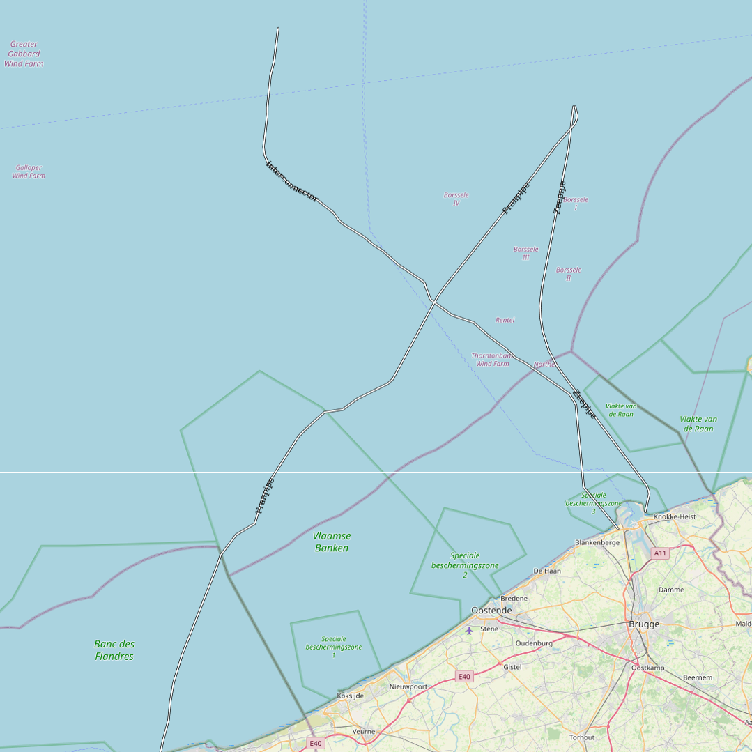
This dataset represents the exact location of gas pipelines installed in the Belgian Part of the North Sea.
-
The Royal Decree of 22 May 2019 establishing a marine spatial plan defines 2 potential seaport expansion zones: Potential harbour extension Oostende (Art. 12§2), Potential harbour extension Zeebrugge (Art. 12§3). It replaces the 2014 Marine Spatial Plan, which is included for completeness. The Royal Decree of 20 March 2014 establishing a marine spatial plan defines in its Art. 9. § 10, two zones (Art. 9 §10 zone 1, Ostend, Art. 9 §10 zone 2, Zeebrugge) for the potential extension of the sea ports of Ostend en Zeebrugge. These zones are made available digitally in the resource described by this metadata document. Please refer to the Belgian official gazette (\"Moniteur belge/Belgisch Staatsblad\") for official reference information.
-

The Royal Decree of 22 May 2019 establishing a marine spatial plan defines 1 coastal protection experiments zone: Zone for coastal protection experiments (Art. 16§2). It replaces the 2014 Marine Spatial Plan, which is included for completeness. The Royal Decree of 20 March 2014 establishing a marine spatial plan defines in its Art. 12. §1 one zone for coastal protection experiments. This zone is made available digitally in the resource described by this metadata document. Please refer to the Belgian official gazette (\"Moniteur belge/Belgisch Staatsblad\") for official reference information.
-

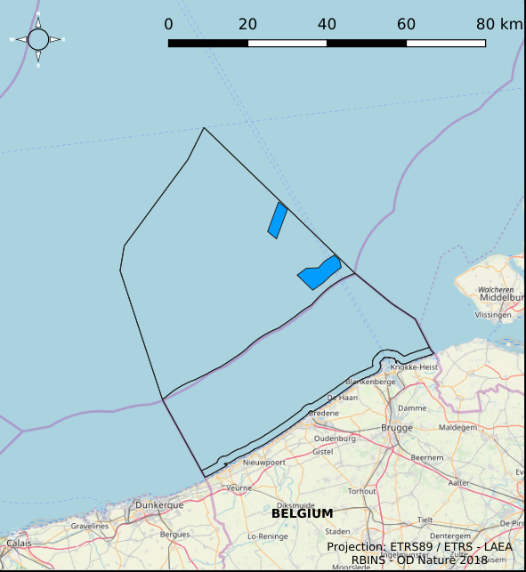
This dataset is part of the 2018 Belgian submission for the Marine Strategy Framework Directive (MSFD) linked to descriptor 11, criterion 1. This dataset describes the impulsive noise generated during percussion pile emplacement for offshore wind farm construction and unexploded ordnance (UxO) explosions. Impulsive underwater sound (pressure) was measured during pile driving operations in Belgian waters, for different types of foundations (monopiles of different diameters, foundations of ducts with a smaller diameter) and hydraulic hammers with different energy powers. The results of measurements at Bligh Bank and Thornton Bank, with a resulting extrapolation of zero to peak noise level (Lz-p) at 750m and Sound Exposure Level (SEL) (no mitigation measures deployed), are presented (Norro et al., 2013).
-
The Royal Decree of 22 May 2019 establishing a marine spatial plan defines 8 scientific research, recreation, radars and masts zones: Scientific research (Art. 19§1), Area for test projects (Art. 19§2), Calibration of acoustic measuring devices (Art. 19§3), Industrial research and demonstration projects (Art. 19§4), Reference zone for monitoring impact of windmills and sand exploitation (Art. 19§5), Recreative activities (Art. 20§1), Recreative fisheries (Art. 20§2), Beaconing and installation of measuring poles, radars and masts (Art. 21§1). It replaces the 2014 Marine Spatial Plan, which is included for completeness. The Royal Decree of 20 March 2014 establishing a marine spatial plan defines in its Art. 15, four zones designated for scientific research, recreative activities, radars and masts: one for scientific research (Art. 15. § 1, the whole Belgian Part of the North Sea), one for recreative activities (Art. 15. § 2, the whole Belgian Part of the North Sea) and one for radars and masts (Art. 15. § 4, the whole Belgian Part of the North Sea) and one for industrial research, experimentations in realistic conditions and demonstration projects (Art. 15. § 5, the whole Belgian Part of the North Sea). These zones are made available digitally in the resource described by this metadata document. Please refer to the Belgian official gazette (\"Moniteur belge/Belgisch Staatsblad\") for official reference information.
-

This dataset represents the exact location of active telecommunication cables (verified in 2010) installed in the Belgian Part of the North Sea.
-
The Royal Decree of 22 May 2019 establishing a marine spatial plan defines 4 aquaculture zones: Zone 1 for aquaculture (Eastern zone) (Art. 14§1), Zone 2 for aquaculture (Noordhinder Noord) (Art. 14§2), Zone 3 for aquaculture (Noordhinder Zuid) (Art. 14§3), Zone 4 for aquaculture (Fairybank) (Art. 14§3). It replaces the 2014 Marine Spatial Plan, which is included for completeness. The Royal Decree of 20 March 2014 establishing a marine spatial plan defines in its Art. 10, two zones for sustainable aquaculture: Zone 1 for sustainable aquaculture, Art. 10 § 2 Zone 1; Zone 2 for sustainable aquaculture, Art. 10 § 2 Zone 2. These zones are made available digitally in the resource described by this metadata document. Please refer to the Belgian official gazette (\"Moniteur belge/Belgisch Staatsblad\") for official reference information.