 geo.be Metadata Catalog
Royal Belgian Institute for Natural Sciences (RBINS), Directorate Natural Environment (OD Nature)
Type of resources
Topics
INSPIRE themes
Keywords
Contact for the resource
Provided by
Years
Formats
Representation types
-
The Royal Decree of 22 May 2019 establishing a marine spatial plan defines 6 measuring poles: Measuring pole MOW.0 (Art. 21§2), Measuring pole MOW.1 (Art. 21§2), Measuring pole MOW.2 (Art. 21§2), Measuring pole MOW.3 (Art. 21§2), Measuring pole MOW.4 (Art. 21§2), Measuring pole Westhinder (Art. 21§2). It replaces the 2014 Marine Spatial Plan, which is included for completeness. The Royal Decree of 20 March 2014 establishing a marine spatial plan defines in its Art. 15. §3, one set of measuring pole locations. These locations are made available digitally in the resource described by this metadata document. Please refer to the Belgian official gazette (\"Moniteur belge/Belgisch Staatsblad\") for official reference information.
-
The Royal Decree of 22 May 2019 establishing a marine spatial plan defines 5 commercial and industrial zones: Zone A for commercial and industrial activities (Art. 23§1), Zone B for commercial and industrial activities (Art. 23§1), Zone C for commercial and industrial activities (Art. 23§1), Zone D for commercial and industrial activities (Art. 23§1), Zone E for commercial and industrial activities (Art. 23§1). Please refer to the Belgian official gazette (\"Moniteur belge/Belgisch Staatsblad\") for official reference information.
-

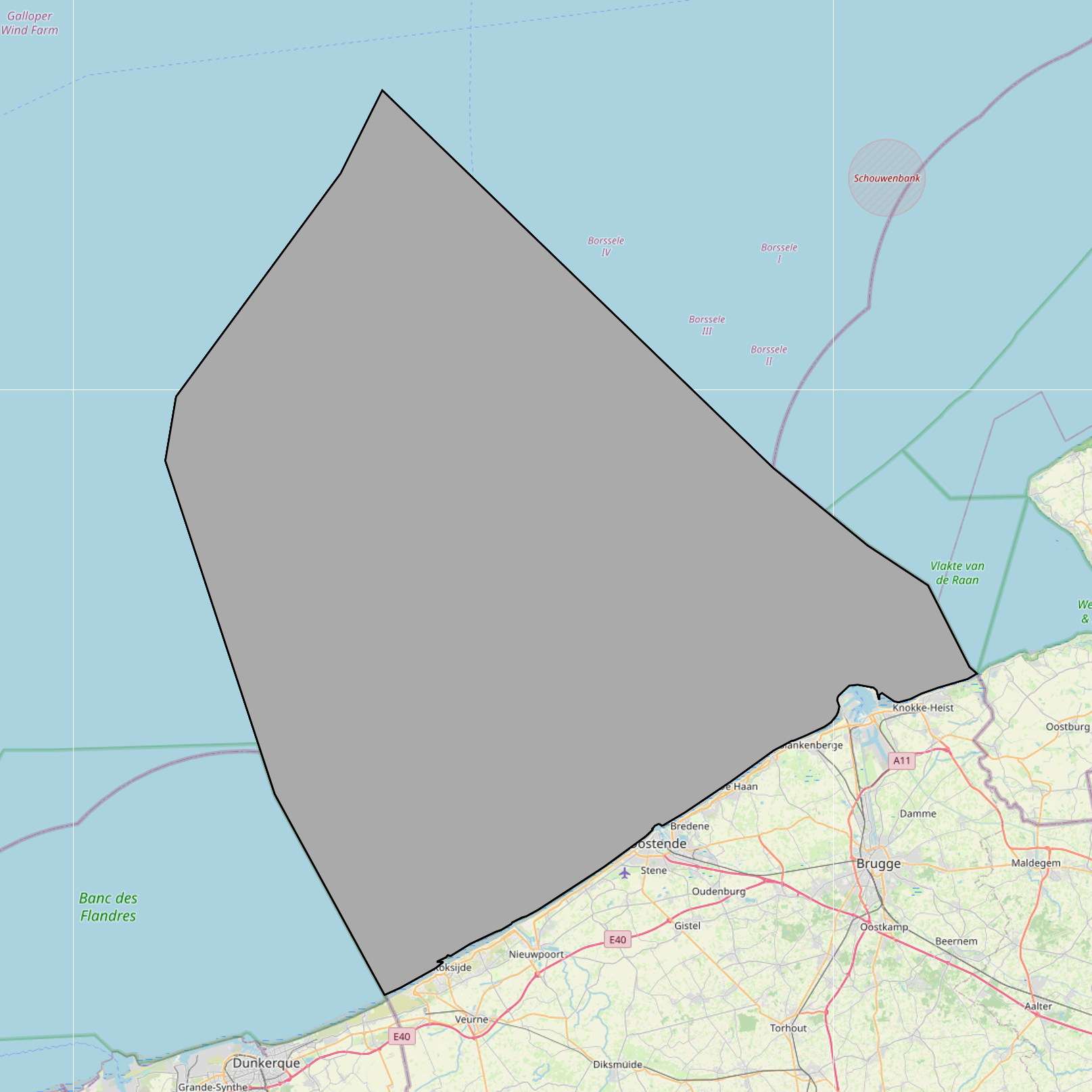
The Royal Decree of 22 May 2019 establishing a marine spatial plan defines 12 sand and gravel extraction zones: Sand and gravel exploitation sector 1a (Thorntonbank) (Art. 15§1), Sand and gravel exploitation sector 2br (Buiten Ratel) (Art. 15§1), Sand and gravel exploitation sector 2kb (Kwintebank) (Art. 15§1), Sand and gravel exploitation sector 2od (Oostdyck) (Art. 15§1), Sand and gravel exploitation sector 3a (Sierra Ventana) (Art. 15§1), Sand and gravel exploitation sector 3b (Sierra Ventana) (Art. 15§1), Sand and gravel exploitation sector 4a (Noordhinder) (Art. 15§1), Sand and gravel exploitation sector 4b (Oosthinder-noord) (Art. 15§1), Sand and gravel exploitation sector 4c (Oosthinder-zuid) (Art. 15§1), Sand and gravel exploitation sector 4d (Westhinder) (Art. 15§1), Sand and gravel exploitation sector 5 (Blighbank) (Art. 15§1), Zone for research of the potential of the exploration and exploitation of sand and gravel (Art. 15§4). It replaces the 2014 Marine Spatial Plan, which is included for completeness.. The Royal Decree of 20 March 2014 establishing a marine spatial plan defines in its Art. 11., eleven Management zones with regards to sand and gravel extraction: ten sand and gravel exploitation zones (Thorntonbank, Art. 11 § 1 Sector 1a, Kwintebank, Art. 11 § 1 Sector 2kb, Buiten Ratel, Art. 11 § 1 Sector 2br, Oostdyck, Art. 11 § 1 Sector 2od, Sierra Ventana, Art. 11 § 1 Sector 3a, Sierra Ventana, Art. 11 § 1 Sector 3b, Noord Hinder, Art. 11 § 1 Sector 4a, Oosthinder-noord, Art. 11 § 1 Sector 4b, Oosthinder-zuid, Art. 11 § 1 Sector 4c, Westhinder, Art. 11 § 1 Sector 4d) and one reference zone for monitoring impact of windmills and sand exploitation (Art. 11 § 3). These zones are made available digitally in the resource described by this metadata document. Please refer to the Belgian official gazette (\"Moniteur belge/Belgisch Staatsblad\") for official reference information.
-

The Royal Decree of 22 May 2019 establishing a marine spatial plan defines in its Art. 11. five dredged material disposal sites (Dredged material disposal site S1, Art. 11 § 1.1°; Dredged material disposal site S2, Art. 11 § 1.2°; Dredged material disposal site Bruggen en Wegen Oostende, Art. 11 § 1.3°; Dredged material disposal site Bruggen en Wegen Zeebrugge Oost, Art. 11 § 1.4°; Dredged material disposal site Bruggen en Wegen Nieuwpoort, Art. 11 § 1.5°). Futhermore, additional zones are defined for the future replacement of dredging areas as defined in Art. 11 §3, §5, §7 and §9. It replaces the 2014 Marine Spatial Plan, which is included for completeness. The Royal Decree of 20 March 2014 establishing a marine spatial plan defines in its Art. 9. five dredged material disposal sites (Dredged material disposal site S1, Art. 9 § 6.1°; Dredged material disposal site S2, Art. 9 § 6.2°; Dredged material disposal site Bruggen en Wegen Oostende, Art. 9 § 6.3°; Dredged material disposal site Bruggen en Wegen Zeebrugge Oost, Art. 9 § 6.4°; Dredged material disposal site Bruggen en Wegen Nieuwpoort, Art. 9 § 6.5°). These zones are made available digitally in the resource described by this metadata document. Please refer to the Belgian official gazette (\"Moniteur belge/Belgisch Staatsblad\") for official reference information.
-
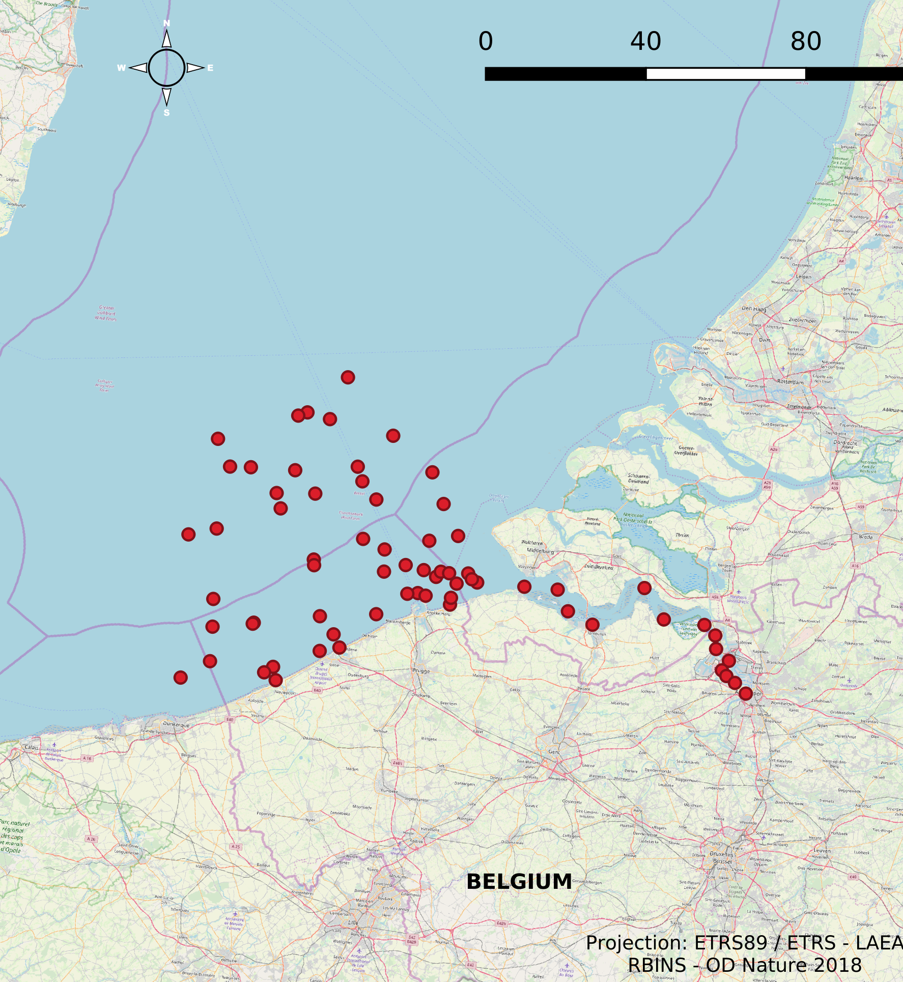
The Scientific Service Management Unit of the Mathematical Model of the North Sea of the Royal Belgian Institute for Natural Sciences has been operating monitoring stations on the Belgian Part of the North Sea since the 1970s. These stations are located in the Scheldt estuary, at open sea and in coastal waters. In 2007, 10 new stations were designated and were placed in the monitoring network needed for the OSPAR convention, the Water Framework Directive and the Marine Strategic Framework Directive. These replaced a series of 54 previous monitoring stations whose data was gathered throughout the years for the Belgian Monitoring Programme and reported according to the recommendations of the OSPAR Convention. This dataset contains information on all monitoring stations ever used by the Scientific Service Management Unit of the Mathematical Model of the North Sea. The dataset provides location, name, operational history and for which reporting obligations they are used.
-

The Royal Decree of 22 May 2019 establishing a marine spatial plan defines 20 shipping and ports zones: Shipping regular regime (Art. 10§1), Northbound traffic flow starting at separation line 'Noordhinder Sud' (Art. 10§2.1°), Separation zone 'Noordhinder Sud' (Art. 10§2.1°), Precaution zone 'Near Thornton and Blighbank ' (Art. 10§2.10°), Northbound traffic flow starting at separation zone 'Off Noordhinder' (Art. 10§2.2°), Separation zone 'Off Noordhinder' (Art. 10§2.2°), Southbound traffic flow starting at separation line 'Off Noordhinder' (Art. 10§2.2°), Precaution zone 'Noordhinder Jonction' (Art. 10§2.3°), Eastbound traffic flow starting at separation line 'At West Hinder' (Art. 10§2.4°), Eastbound traffic flow starting at separation zone 'At West Hinder' (Art. 10§2.4°), Precaution zone 'At West Hinder ' (Art. 10§2.4°), Separation zone 'At West Hinder' (Art. 10§2.4°), Westbound traffic flow starting at separation line 'At West Hinder' (Art. 10§2.4°), Area to be Avoided 'At West Hinder' (Art. 10§2.6°), Deep water route 'Westerschelde approach' (Art. 10§2.7°), Border line 1 of two-way shipping lane 'Westpit' (Art. 10§2.8°), Border line 2 of two-way shipping lane 'Westpit' (Art. 10§2.8°), Precaution zone 'At Gootebank' (Art. 10§2.9°), Anchoring zone 'Oostdyck' (Art. 10§3.1°), Anchoring zone 'Westhinder' (Art. 10§3.2°). It replaces the 2014 Marine Spatial Plan, which is included for completeness. The Royal Decree of 20 March 2014 establishing a marine spatial plan defines in its Art. 9, nine zones with regards to shipping and ports: seven shipping zones (Shipping regular regime, Art. 9 § 1; Shipping route Northhinder South, Art. 9 § 2.1°; Shipping route Northhinder junction, Art. 9 § 2.2°; Shipping route Westhinder, Art. 9 § 2.3°; Shipping route Westhinder precautionary area, Art. 9 § 2.4°; Shipping route Westhinder area to be avoided, Art. 9 § 2.5°; Deep water shipping route Western Scheldt approach, Art. 9 § 2.6°) and two anchorage places (Anchorage place 'Oostdyck', Art. 9 § 4.1° and Anchorage place 'Westhinder', Art. 9 § 4.2°). These zones are made available digitally in the resource described by this metadata document. Please refer to the Belgian official gazette (\"Moniteur belge/Belgisch Staatsblad\") for official reference information.
-
The Royal Decree of 22 May 2019 establishing a marine spatial plan defines 8 scientific research, recreation, radars and masts zones: Scientific research (Art. 19§1), Area for test projects (Art. 19§2), Calibration of acoustic measuring devices (Art. 19§3), Industrial research and demonstration projects (Art. 19§4), Reference zone for monitoring impact of windmills and sand exploitation (Art. 19§5), Recreative activities (Art. 20§1), Recreative fisheries (Art. 20§2), Beaconing and installation of measuring poles, radars and masts (Art. 21§1). It replaces the 2014 Marine Spatial Plan, which is included for completeness. The Royal Decree of 20 March 2014 establishing a marine spatial plan defines in its Art. 15, four zones designated for scientific research, recreative activities, radars and masts: one for scientific research (Art. 15. § 1, the whole Belgian Part of the North Sea), one for recreative activities (Art. 15. § 2, the whole Belgian Part of the North Sea) and one for radars and masts (Art. 15. § 4, the whole Belgian Part of the North Sea) and one for industrial research, experimentations in realistic conditions and demonstration projects (Art. 15. § 5, the whole Belgian Part of the North Sea). These zones are made available digitally in the resource described by this metadata document. Please refer to the Belgian official gazette (\"Moniteur belge/Belgisch Staatsblad\") for official reference information.
-

The Royal Decree of 22 May 2019 establishing a marine spatial plan defines 1 coastal protection experiments zone: Zone for coastal protection experiments (Art. 16§2). It replaces the 2014 Marine Spatial Plan, which is included for completeness. The Royal Decree of 20 March 2014 establishing a marine spatial plan defines in its Art. 12. §1 one zone for coastal protection experiments. This zone is made available digitally in the resource described by this metadata document. Please refer to the Belgian official gazette (\"Moniteur belge/Belgisch Staatsblad\") for official reference information.
-

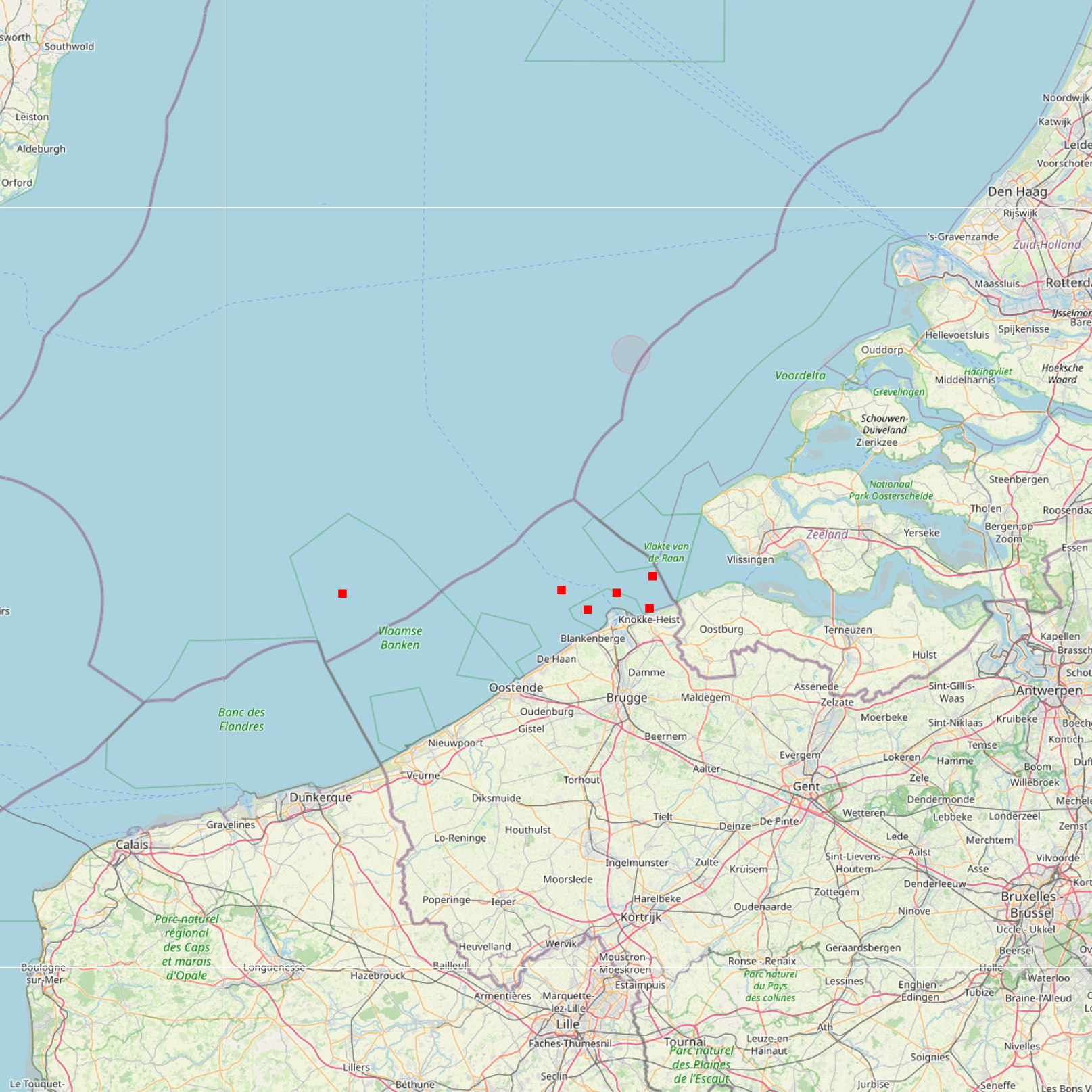
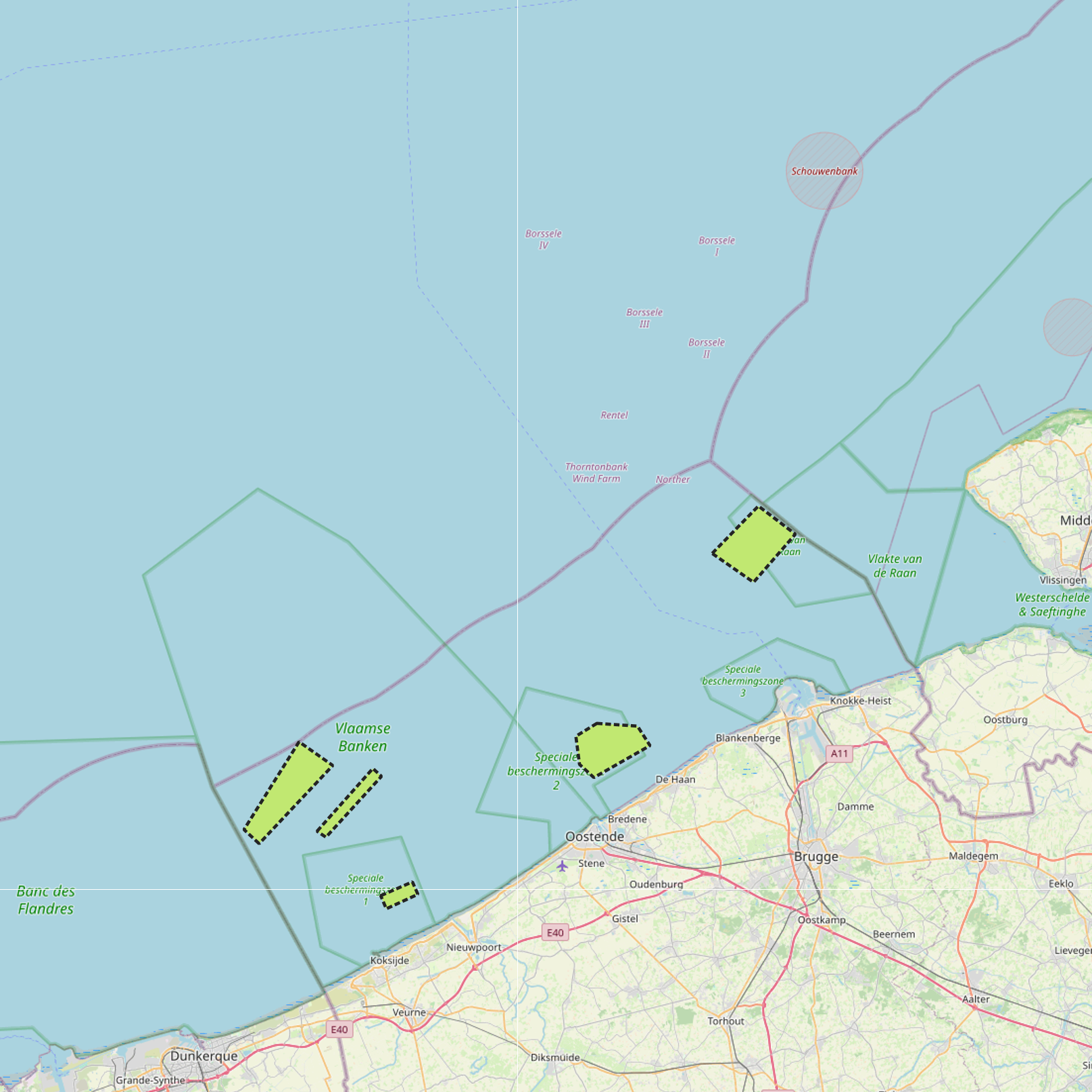
The Royal Decree of 22 May 2019 establishing a marine spatial plan defines 5 nature conservation areas: Special area for conservation 'The Flemish Banks' (Art. 7§1), Special area for conservation 'Vlakte van de Raan' (Art. 7§3), Special protection area for birds - SPA 1 (Art. 7§5.1°), Special protection area for birds - SPA 2 (Art. 7§5.2°), Special protection area for birds - SPA 3 (Art. 7§5.3°). It replaces the 2014 Marine Spatial Plan, which is included for completeness. The Royal Decree of 20 March 2014 establishing a marine spatial plan defines in its Art. 7., six nature conservation sites: two special areas for conservation (Art. 7. §1, Special area for conservation 'Vlaamse Banken' and Art. 7. §3, Special area for conservation 'Trapegeer stroombank'), three special protection zones for birds (Art7§4.1°, SBZ1, Art7§4.2°, SBZ2, Art7§4.3°, SBZ3), and one marine reserve (Art7§8, Marine reserve 'Baai van Heist'). These zones are made available digitally in the resource described by this metadata document. Please refer to the Belgian official gazette (\"Moniteur belge/Belgisch Staatsblad\") for official reference information.
-

The Royal Decree of 22 May 2019 establishing a marine spatial plan defines 11 military use and storage sites for war munition zones: Exercise area for sweeping mines (Buiten Ratel) (Art. 17§1), Exercise area for sweeping mines - NB-01 (Westhinder) (Art. 17§1), Exercise area for sweeping mines - NBH-10 (Wenduine) (Art. 17§1), Exercise area for sweeping mines - QZR 040 (Art. 17§1), Munition destruction area (Art. 17§2), Area for shooting exercises on floating objects (Art. 17§3), Area for exercises in shallow waters (Art. 17§4), Area for shooting exercises from land - big sector (Art. 17§5), Area for shooting exercises from land - medium sector (Art. 17§5), Area for shooting exercises from land - small sector (Art. 17§5), Storage site for war munition Paardenmarkt (Art. 18§1). It replaces the 2014 Marine Spatial Plan, which is included for completeness. The Royal Decree of 20 March 2014 establishing a marine spatial plan defines in its Art. 13. and Art. 14., resp. nine zones for military use and one storage site for war munition: three zones for shooting exercises from land direction sea (Art 13. § 1 small sector, Art 13. § 1 medium sector, Art 13. § 1 large sector), four exercise areas for sweeping mines (Art 13. § 3, Exercise area 1 for sweeping mines, Art 13. § 5, Exercise area 2 for sweeping mines, Art 13. § 9, Exercise area 3 for sweeping mines, Art 13. § 13, Exercise area 4 for sweeping mines), one area for shooting exercises on floating objects (Art 13. § 7), one area for defusing mines (Art 13. § 11) and one zone to safeguard the closed storage site for war munition \"Paardenmarkt\" (Art. 14. § 1). These zones are made available digitally in the resource described by this metadata document. Please refer to the Belgian official gazette (\"Moniteur belge/Belgisch Staatsblad\") for official reference information.