 geo.be Metadata Catalog
Belgian part of the North Sea
Type of resources
Topics
INSPIRE themes
Keywords
Contact for the resource
Provided by
Years
Formats
Representation types
-

This dataset is part of the 2018 Belgian submission for the Marine Strategy Framework Directive (MSFD) linked to descriptor 8, criterion 1. This dataset contains the contaminant concentrations measured in sediments at 10 monitoring stations in the Belgian part of the North Sea between 2011 and 2015. 88 parameters are measured in the upper part of the sea bottom by a Van Veen grab sampler. The contaminants are analyzed on the fraction < 63 µm. PCBs and heavy metals are analyzed by ILVO (and CODA). PBDEs, PAHs and organotin compounds are analysed by KBIN-OD Nature, PAHs and organotin based on an accredited method (ISO/IEC 17025).
-
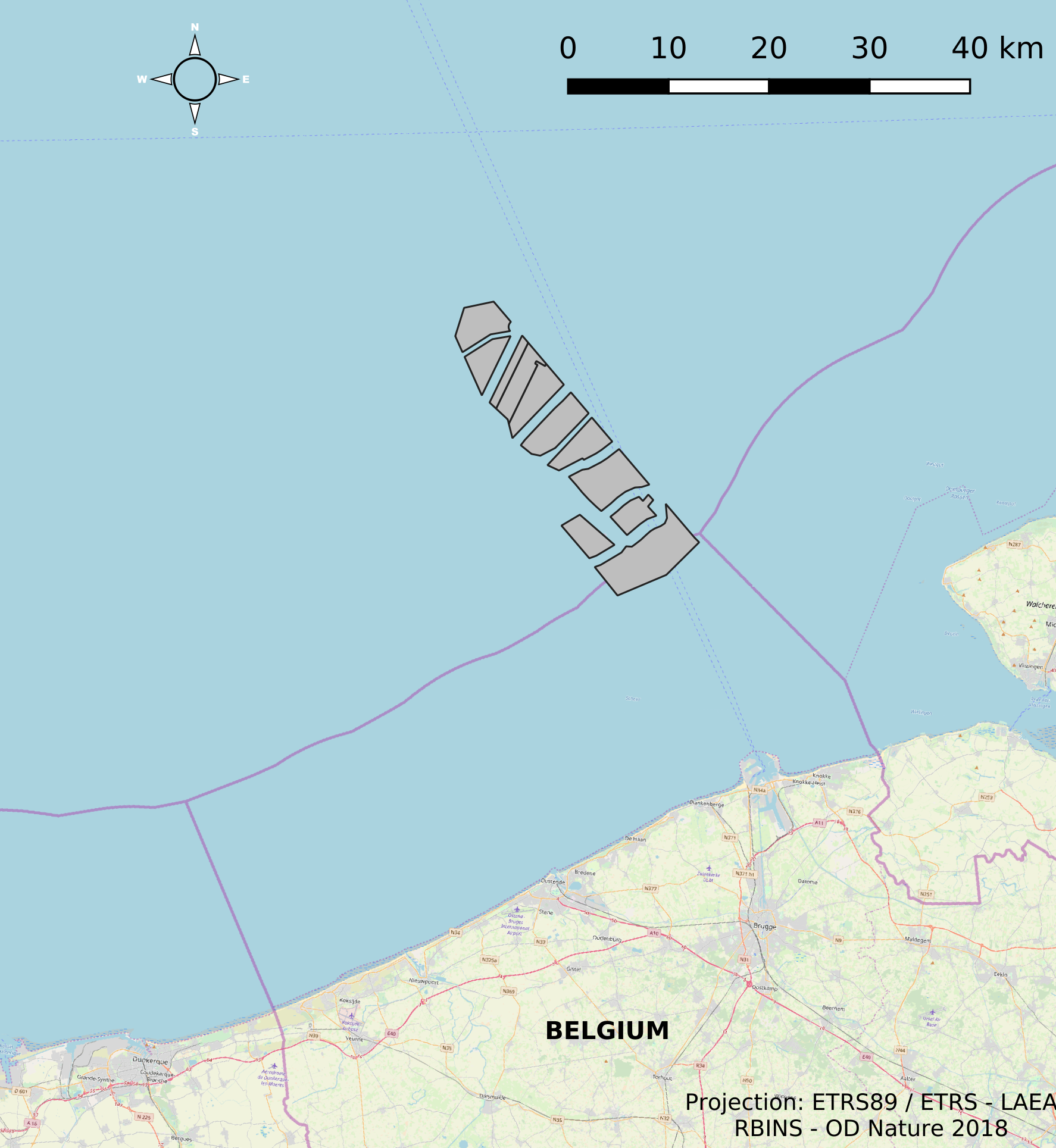
This dataset represents the location of the windfarms concessions in the Belgian Part of the North Sea.
-
This dataset is part of the 2018 Belgian submission for the Marine Strategy Framework Directive (MSFD) linked to descriptor 8, criterion 4. This dataset contains measurements on the 7-Ethoxyresorufin-O-deethylase (EROD) activity in Limanda limanda, Imposex (OTIN in Mytilus edulis), fish diseases and counts of oiled common guillemots in the Belgian part of the North Sea.
-

This dataset represents the exact location of active telecommunication cables (verified in 2010) installed in the Belgian Part of the North Sea.
-
This dataset describes the extents and location of Sandbanks (code 1110) in the Belgian Part of the North Sea (BPNS) as required for article 17 of the Council Directive 92/43/EEC of 21 May 1992 on the conservation of natural habitats and of wild fauna and flora. The Council Directive seeks to contribute to ensuring biodiversity in the European Union by the conservation of natural habitats and wild fauna and flora species.
-

The Royal Decree of 22 May 2019 establishing a marine spatial plan defines 20 shipping and ports zones: Shipping regular regime (Art. 10§1), Northbound traffic flow starting at separation line 'Noordhinder Sud' (Art. 10§2.1°), Separation zone 'Noordhinder Sud' (Art. 10§2.1°), Precaution zone 'Near Thornton and Blighbank ' (Art. 10§2.10°), Northbound traffic flow starting at separation zone 'Off Noordhinder' (Art. 10§2.2°), Separation zone 'Off Noordhinder' (Art. 10§2.2°), Southbound traffic flow starting at separation line 'Off Noordhinder' (Art. 10§2.2°), Precaution zone 'Noordhinder Jonction' (Art. 10§2.3°), Eastbound traffic flow starting at separation line 'At West Hinder' (Art. 10§2.4°), Eastbound traffic flow starting at separation zone 'At West Hinder' (Art. 10§2.4°), Precaution zone 'At West Hinder ' (Art. 10§2.4°), Separation zone 'At West Hinder' (Art. 10§2.4°), Westbound traffic flow starting at separation line 'At West Hinder' (Art. 10§2.4°), Area to be Avoided 'At West Hinder' (Art. 10§2.6°), Deep water route 'Westerschelde approach' (Art. 10§2.7°), Border line 1 of two-way shipping lane 'Westpit' (Art. 10§2.8°), Border line 2 of two-way shipping lane 'Westpit' (Art. 10§2.8°), Precaution zone 'At Gootebank' (Art. 10§2.9°), Anchoring zone 'Oostdyck' (Art. 10§3.1°), Anchoring zone 'Westhinder' (Art. 10§3.2°). It replaces the 2014 Marine Spatial Plan, which is included for completeness. The Royal Decree of 20 March 2014 establishing a marine spatial plan defines in its Art. 9, nine zones with regards to shipping and ports: seven shipping zones (Shipping regular regime, Art. 9 § 1; Shipping route Northhinder South, Art. 9 § 2.1°; Shipping route Northhinder junction, Art. 9 § 2.2°; Shipping route Westhinder, Art. 9 § 2.3°; Shipping route Westhinder precautionary area, Art. 9 § 2.4°; Shipping route Westhinder area to be avoided, Art. 9 § 2.5°; Deep water shipping route Western Scheldt approach, Art. 9 § 2.6°) and two anchorage places (Anchorage place 'Oostdyck', Art. 9 § 4.1° and Anchorage place 'Westhinder', Art. 9 § 4.2°). These zones are made available digitally in the resource described by this metadata document. Please refer to the Belgian official gazette (\"Moniteur belge/Belgisch Staatsblad\") for official reference information.
-
This dataset is part of the 2018 Belgian submission for the Marine Strategy Framework Directive (MSFD) linked to descriptor 6, criterion 5. It comprises three datasets used to assess the sea floor integrity for ensuring a proper functioning of the ecosystem.The dataset on the study of the fauna associated with cobble fields (hard substrates) describes the gravel analysis performed in the Belgian part of the North Sea between 2015 and 2017. Information on the location, date and procedure used for the sediment sampling is provided as well as the description of species found in the samples.The occurrence of important benthic species. The status of benthic habitats (soft substrates).
-
This dataset is part of the 2018 Belgian submission for the Marine Strategy Framework Directive (MSFD) linked to descriptor 10, criterion 1. The seafloor dataset describes the litter gathered between 2012 and 2014 during beam trawl (BTS) fishery surveys in the Belgian part of the North Sea (BPNS). It provides the date, location and haul information, type of litter found and information in the size of the items. Additionally the ship name and cruise references are reported. The data is recorded following ICES guidelines allowing future inclusion in the ICES online database DATRAS (Database of Trawl Survery). The sludge dataset describes the litter found between 2013 and 2016 on dredge disposal sites located in the coastal area of the Belgian part of the North Sea (BPNS). It provides the date, location, amount and type of litter as well as methodological information (e.g. mesh size). Additionally, the ship name and cruise references are reported. The beach litter dataset contains information on beach litter for the period 2012-2016 washed ashore on two reference beaches (Oostende Halve Maan & Oostende Raversijde). 40 surveys (100m transects) have been executed until January 2017. Monitoring & data recording has been done according to the OSPAR Guideline for Monitoring Marine Litter on the beaches in the OSPAR maritime area (OSPAR, 2010). Besides the number of litter items, the category is also noted. The dataset is characterized by a high variation in the number of items. The data are reported to OSPAR beach litter database. Conclusions: see https://odnature.naturalsciences.be/msfd/nl/assessments/2018/page-d10
-

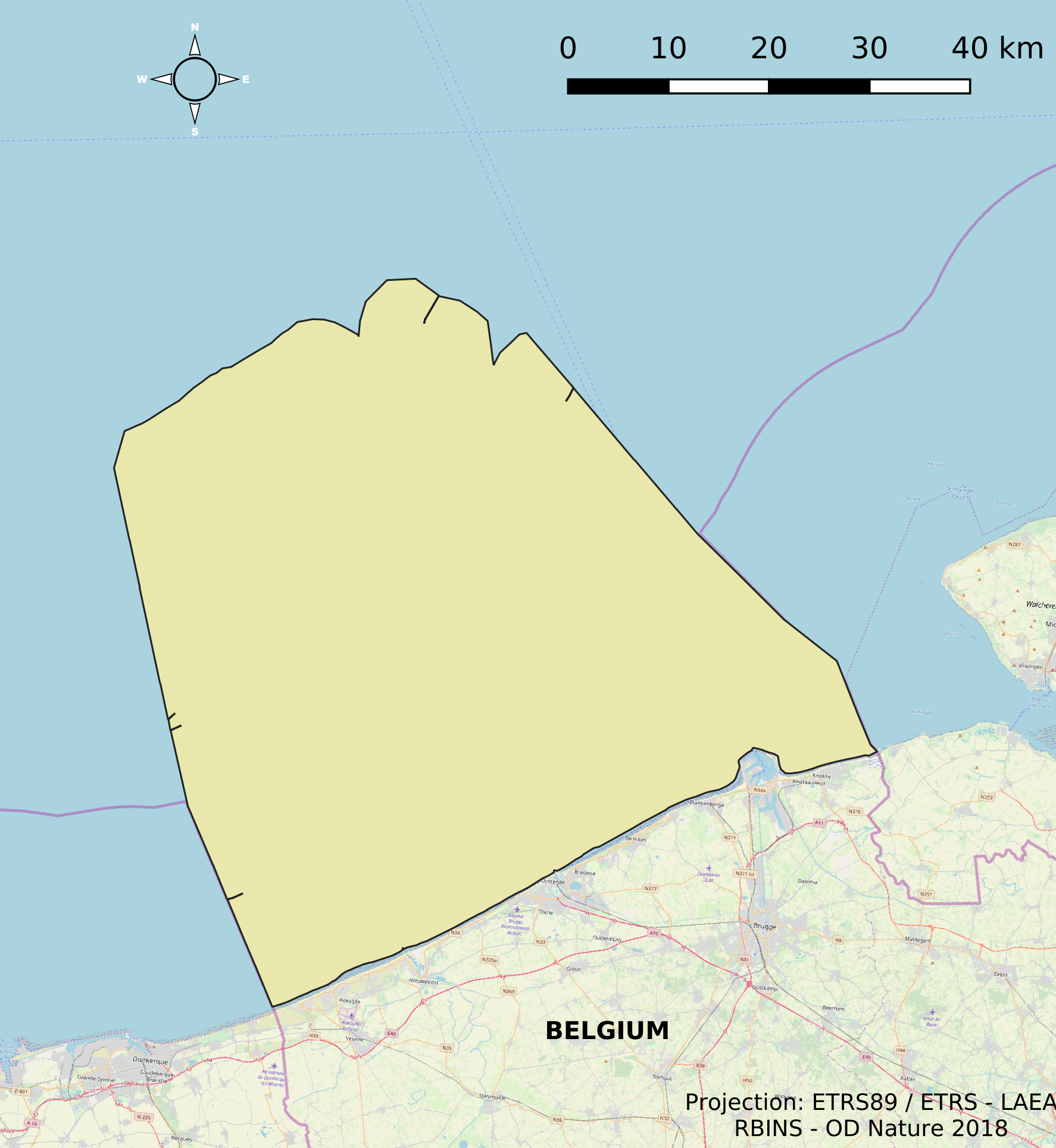
The dataset contains the borders of the Belgian marine waters in the North Sea and the different geographical areas (‘reporting units’) used when reporting in the frame of the the Marine Strategy Framework Directive 2008/56/EC (MSFD) and the Water Framework directive 2000/60/EC (WFD). The ecological status in the frame of WFD is reported for the coastal waters, defined as the one-nautical mile area, while the chemical status needs to be reported for the territorial waters (up to 12 nautical miles). MSFD requires information for the whole area, encompassing the territorial waters and the Belgian Exclusive Economic Zone. For some descriptors, results have been reported separately for the WFD subdivisions during the update of the initial assessment in 2018.
-
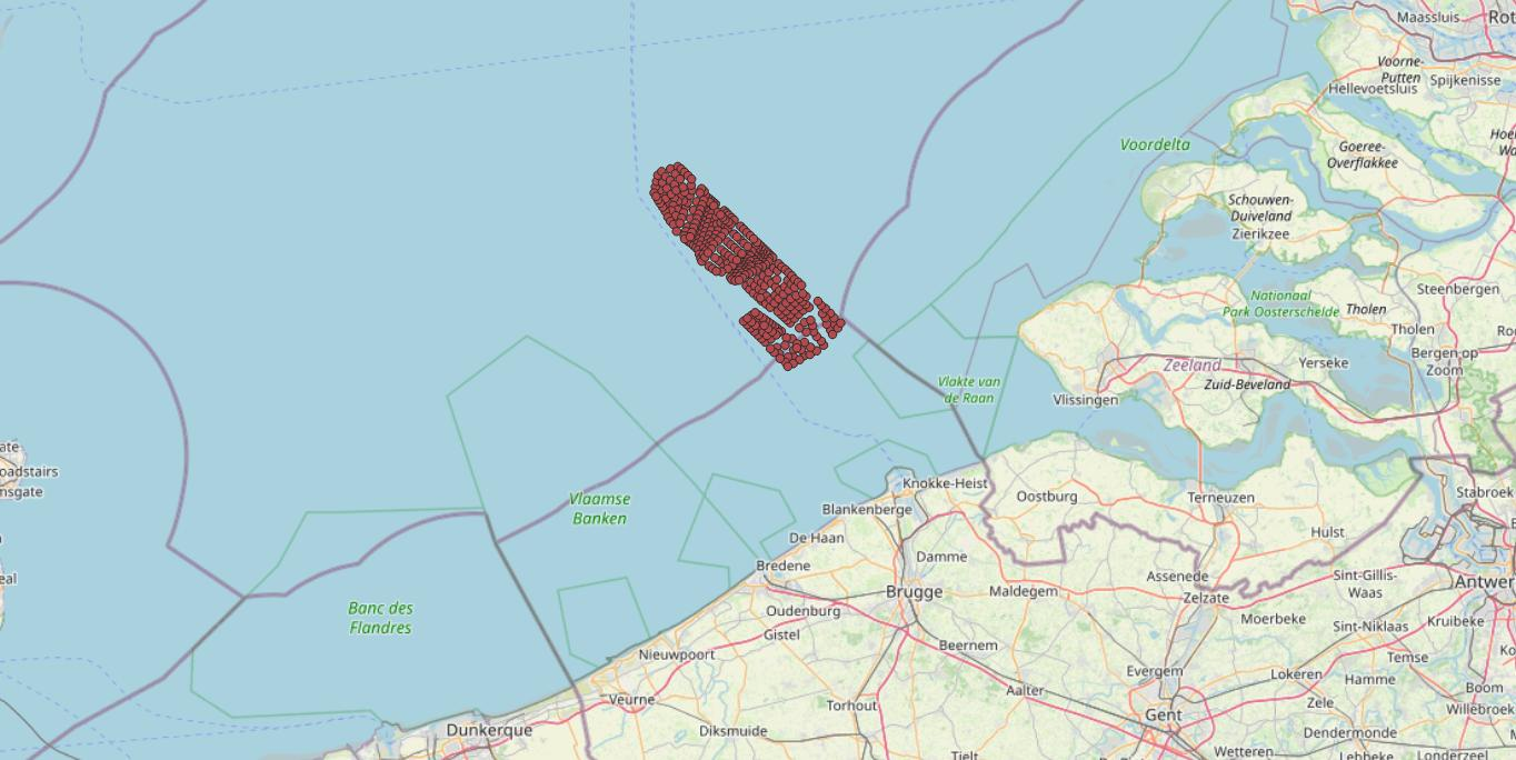
This dataset represents the exact location of the wind turbines in the Belgian Part of the North Sea.