 geo.be Metadata Catalog
Directive 2008/56/EC
Type of resources
Topics
INSPIRE themes
Keywords
Contact for the resource
Provided by
Years
Formats
Representation types
-

This dataset is part of the 2024 Belgian submission for the Marine Strategy Framework Directive (MSFD) linked to descriptor 1, criterion 3. This dataset reports the breeding success (population demographic characteristics) of benthic-feeding, pelagic-feeding, surface-feeding and wading birds breeding along the Belgian coast.
-
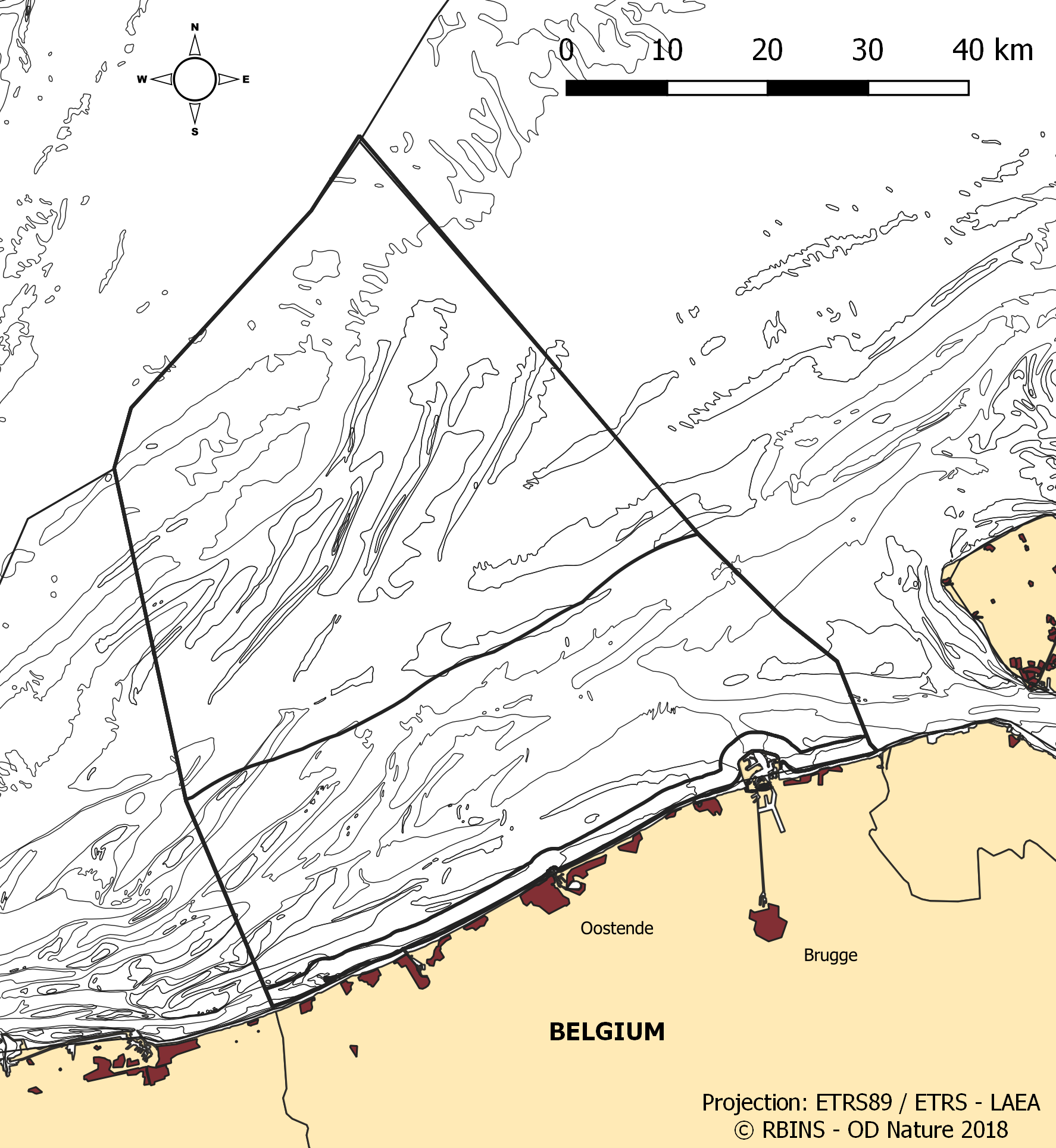
The dataset contains the borders of the Belgian marine waters in the North Sea and the different geographical areas (‘reporting units’) used when reporting in the frame of the the Marine Strategy Framework Directive 2008/56/EC (MSFD) and the Water Framework directive 2000/60/EC (WFD). The ecological status in the frame of WFD is reported for the coastal waters, defined as the one-nautical mile area, while the chemical status needs to be reported for the territorial waters (up to 12 nautical miles). MSFD requires information for the whole area, encompassing the territorial waters and the Belgian Exclusive Economic Zone. For some descriptors, results have been reported separately for the WFD subdivisions during the update of the initial assessment in 2018.
-
This dataset is part of the 2018 Belgian submission for the Marine Strategy Framework Directive (MSFD) linked to descriptor 8, criterion 1. This dataset describes the contaminant concentrations in biota. The priority substances mercury, hexachlorobutadiene and hexachlorobenzene are measured in mussels and flounder in the BPNS. Results for other parameters that are part of the OSPAR Coordinated Environmental Monitoring Program are also included: polychlorinated biphenyls (PCBs), polycyclic aromatic hydrocarbons (PAHs), heavy metals, organotin-compounds and polybrominated diphenyl ethers (PBDEs) for the period 2011-2016. The analyses are performed by ILVO and KBIN-OD Nature that both participate in the Quasimeme ring tests for additional quality control. Bird eggs of 2008, 2010 and 2015 are measured for mercury (Hg), dichlorodiphenyltrichloroethane (DDT), hexachlorobenzene (HCB) and hexachlorocyclohexane (HCH). Eggs from the are measured and compared with OSPAR norms Common Tern (Sterna hirundo) are gathered in Zeebrugge and are analyzed by the Insitut für vogelforschung in Wilhelmshaven according to a standard protocol.
-
This dataset is part of the 2024 Belgian submission for the Marine Strategy Framework Directive (MSFD) linked to descriptor 7, criterion 1. This dataset describes the zones that are subject to noticeable permanent alteration of the hydrographic conditions due to human activities and man-made infrastructures for the time period 1992-2022. The data format is shapefiles and includes the zone area (m²) as attribute.
-
This dataset is part of the 2018 Belgian submission for the Marine Strategy Framework Directive (MSFD) linked to descriptor 6, criterion 2. This dataset describes and maps the physical disturbance to the seabed in the Belgian part of the North Sea (BPNS) between 2011 and 2016. The dataset combines different layers of human activities leading to a disturbance of the seabed, including power cables with its rock dump, dredging and dumping, extraction, war ammunition stocking and wind farms. The area disturbed is mapped and quantified per year, per activity and per benthic broad habitat.
-
This dataset presents findings from an environmental impact assessment conducted along three gradients extending northeastward, southeastward, and southwestward from the Princess Elisabeth Energy Island. Samples were collected at 20 locations in 2024, and 8 locations in 2025 in triplicate, using a 0.1 m² Van Veen Grab, assessing sediment grain size distribution and total organic carbon content. Macrobenthos samples were preserved, stained, and analyzed in the laboratory.
-
This dataset is part of the 2024 Belgian submission for the Marine Strategy Framework Directive (MSFD) linked to descriptor 6, criterion 4. This dataset reports the ratio of hard-substrate surface area (colonised by hard-substrate epifauna) to soft-sediment surface area in the Belgian part of the North Sea (BPNS), which should not show a negative trend.
-
This dataset is part of the 2018 Belgian submission for the Marine Strategy Framework Directive (MSFD) linked to descriptor 7, criterion 1. This dataset describes the impact of an offshore windmills farm on the hydrodynamics in the Belgian part of the North Sea (BPNS). Originally, it is a NetCDF file with the results of the reference simulation made with the COHERENS (COupled Hydrodynamical Ecological model for REgioNal Shelf seas) hydrodynamic model only forced by tides (no wind effect). Model resolution : ~ 12.5m. It contains both the reference situation which is a simulation without any windmill and the modeling result of the influence by the windmills on the hydrodynamic in the BPNS. The dataset contains the results on the most inner nested grid level for one reference spring-neap cycle: - hourly sea surface elevation - hourly bottom shear stress - hourly 3D horizontal velocity components (u,v) - hourly 3D eddy viscosity - time-averaged bottom shear stress over the reference spring-neap cycle - percentile 90 of the bottom shear stress for the reference spring-neap cycle - percentile 90 of the specific kinetic energy at the sea bed - accumulated time during which sedimentation processes are dominant - accumulated time during which re-suspension processes are dominant.
-
This dataset is part of the 2024 Belgian submission for the Marine Strategy Framework Directive (MSFD) linked to descriptor 6, criterion 2. This dataset describes and maps the physical disturbance to the seabed in the Belgian part of the North Sea (BPNS) between 2010 and 2021. The dataset combines different layers of human activities leading to a disturbance of the seabed, including 'soft' beach and foreshore nourishments, dredging and dumping, sand extraction, fisheries, burial of cables, war ammunition stocking and construction of wind farms. The area disturbed is mapped and quantified per year and per activity, and plotted on the predominant broad-scale benthic habitat types of the EUSeaMap 2023. Infield cables from wind farms and Elia cables (NEMO and MOG) are not shown due to mutual agreements. This dataset is part of the 2024 Belgian submission for the Marine Strategy Framework Directive (MSFD) linked to descriptor 6, criterion 1. This dataset describes and maps the physical loss of the seabed in the Belgian part of the North Sea (BPNS) between 2010 and 2021. The dataset combines different layers of human activities leading to a loss of the seabed, including 'hard' coastal defence structures, ports, measuring poles and radar station, protection of pipelines and cables, construction of wind farms, and wrecks and other obstacles. The area lost is mapped and quantified per year and per activity, and plotted on the predominant broad-scale benthic habitat types of the EUSeaMap 2023.
-
This dataset is part of the 2024 Belgian submission for the Marine Strategy Framework Directive (MSFD) linked to descriptor 2, criterion 1. This dataset lists the newly-introduced species encountered in the Belgian part of the North Sea (BPNS) between 2016 and 2021, combining dedicated non-indigenous species (NIS) surveys of artificial hard substrates with incidental NIS records collected during the soft-sediment and epibenthos monitoring programmes.