 geo.be Metadata Catalog
Royal Belgian Institute for Natural Sciences (RBINS), Directorate Natural Environment (OD Nature)
Type of resources
Topics
INSPIRE themes
Keywords
Contact for the resource
Provided by
Years
Formats
Representation types
-

The Royal Decree of 22 May 2019 establishing a marine spatial plan defines 20 shipping and ports zones: Shipping regular regime (Art. 10§1), Northbound traffic flow starting at separation line 'Noordhinder Sud' (Art. 10§2.1°), Separation zone 'Noordhinder Sud' (Art. 10§2.1°), Precaution zone 'Near Thornton and Blighbank ' (Art. 10§2.10°), Northbound traffic flow starting at separation zone 'Off Noordhinder' (Art. 10§2.2°), Separation zone 'Off Noordhinder' (Art. 10§2.2°), Southbound traffic flow starting at separation line 'Off Noordhinder' (Art. 10§2.2°), Precaution zone 'Noordhinder Jonction' (Art. 10§2.3°), Eastbound traffic flow starting at separation line 'At West Hinder' (Art. 10§2.4°), Eastbound traffic flow starting at separation zone 'At West Hinder' (Art. 10§2.4°), Precaution zone 'At West Hinder ' (Art. 10§2.4°), Separation zone 'At West Hinder' (Art. 10§2.4°), Westbound traffic flow starting at separation line 'At West Hinder' (Art. 10§2.4°), Area to be Avoided 'At West Hinder' (Art. 10§2.6°), Deep water route 'Westerschelde approach' (Art. 10§2.7°), Border line 1 of two-way shipping lane 'Westpit' (Art. 10§2.8°), Border line 2 of two-way shipping lane 'Westpit' (Art. 10§2.8°), Precaution zone 'At Gootebank' (Art. 10§2.9°), Anchoring zone 'Oostdyck' (Art. 10§3.1°), Anchoring zone 'Westhinder' (Art. 10§3.2°). It replaces the 2014 Marine Spatial Plan, which is included for completeness. The Royal Decree of 20 March 2014 establishing a marine spatial plan defines in its Art. 9, nine zones with regards to shipping and ports: seven shipping zones (Shipping regular regime, Art. 9 § 1; Shipping route Northhinder South, Art. 9 § 2.1°; Shipping route Northhinder junction, Art. 9 § 2.2°; Shipping route Westhinder, Art. 9 § 2.3°; Shipping route Westhinder precautionary area, Art. 9 § 2.4°; Shipping route Westhinder area to be avoided, Art. 9 § 2.5°; Deep water shipping route Western Scheldt approach, Art. 9 § 2.6°) and two anchorage places (Anchorage place 'Oostdyck', Art. 9 § 4.1° and Anchorage place 'Westhinder', Art. 9 § 4.2°). These zones are made available digitally in the resource described by this metadata document. Please refer to the Belgian official gazette (\"Moniteur belge/Belgisch Staatsblad\") for official reference information.
-
The Royal Decree of 22 May 2019 establishing a marine spatial plan defines 7 cultural heritage (wrecks) zones: 'HMS Briljant' wreck (Art. 22), 'SS Kilmore' wreck (Art. 22), '’t Vliegend Hart' wreck (Art. 22), 'U-11' wreck (Art. 22), 'West Hinder' wreck (Art. 22), Wooden wreck 'Oostende' (Art. 22), Wreck site 'Buiten Ratel' (Art. 22). Please refer to the Belgian official gazette (\"Moniteur belge/Belgisch Staatsblad\") for official reference information.
-
The Royal Decree of 22 May 2019 establishing a marine spatial plan defines 6 energy, cable and pipeline zones: Area 1 for renewable energy (Eastern zone) (Art. 8§1), Area 2 for renewable energy (Noordhinder North) (Art. 8§2), Area 3 for renewable energy (Noordhinder Zuid) (Art. 8§3), Area for renewable energy - zone 4 (Fairybank) (Art. 8§3), Modular offshore grid for transmission of energy (Art. 8§5), Pipelines and cables corridor (Art. 9§1). It replaces the 2014 Marine Spatial Plan, which is included for completeness. The Royal Decree of 20 March 2014 establishing a marine spatial plan defines in its Art. 8., five energy, cables and pipelines zones: one zone for domain concessions to construct and exploit installations for the production of electricity from water, currents or wind (Area for renewable energy (initially wind farms), Art. 8. § 1), one zone for domain concessions to construct and exploit installations for the transport of electricity (Plug at sea, Art. 8. § 3), two zones for installations for energy storage (Energy atoll 1, Art. 8. § 5 zone 1 and Energy atoll 2, Art. 8. § 5 zone 2) and one zone to construct and exploit pipelines and cables (Pipelines and cables corridor, Art. 8. § 7). These zones are made available digitally in the resource described by this metadata document. Please refer to the Belgian official gazette (\"Moniteur belge/Belgisch Staatsblad\") for official reference information.
-
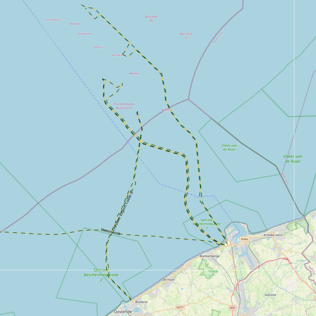
This dataset represents the exact location of electrical cables installed in the Belgian Part of the North Sea, including these for for the wind farms.
-

This dataset is part of the 2018 Belgian submission for the Marine Strategy Framework Directive (MSFD) linked to descriptor 6, criterion 5. It comprises three datasets used to assess the sea floor integrity for ensuring a proper functioning of the ecosystem.The dataset on the study of the fauna associated with cobble fields (hard substrates) describes the gravel analysis performed in the Belgian part of the North Sea between 2015 and 2017. Information on the location, date and procedure used for the sediment sampling is provided as well as the description of species found in the samples.The occurrence of important benthic species. The status of benthic habitats (soft substrates).
-
The Royal Decree of 22 May 2019 establishing a marine spatial plan defines 5 commercial and industrial zones: Zone A for commercial and industrial activities (Art. 23§1), Zone B for commercial and industrial activities (Art. 23§1), Zone C for commercial and industrial activities (Art. 23§1), Zone D for commercial and industrial activities (Art. 23§1), Zone E for commercial and industrial activities (Art. 23§1). Please refer to the Belgian official gazette (\"Moniteur belge/Belgisch Staatsblad\") for official reference information.
-

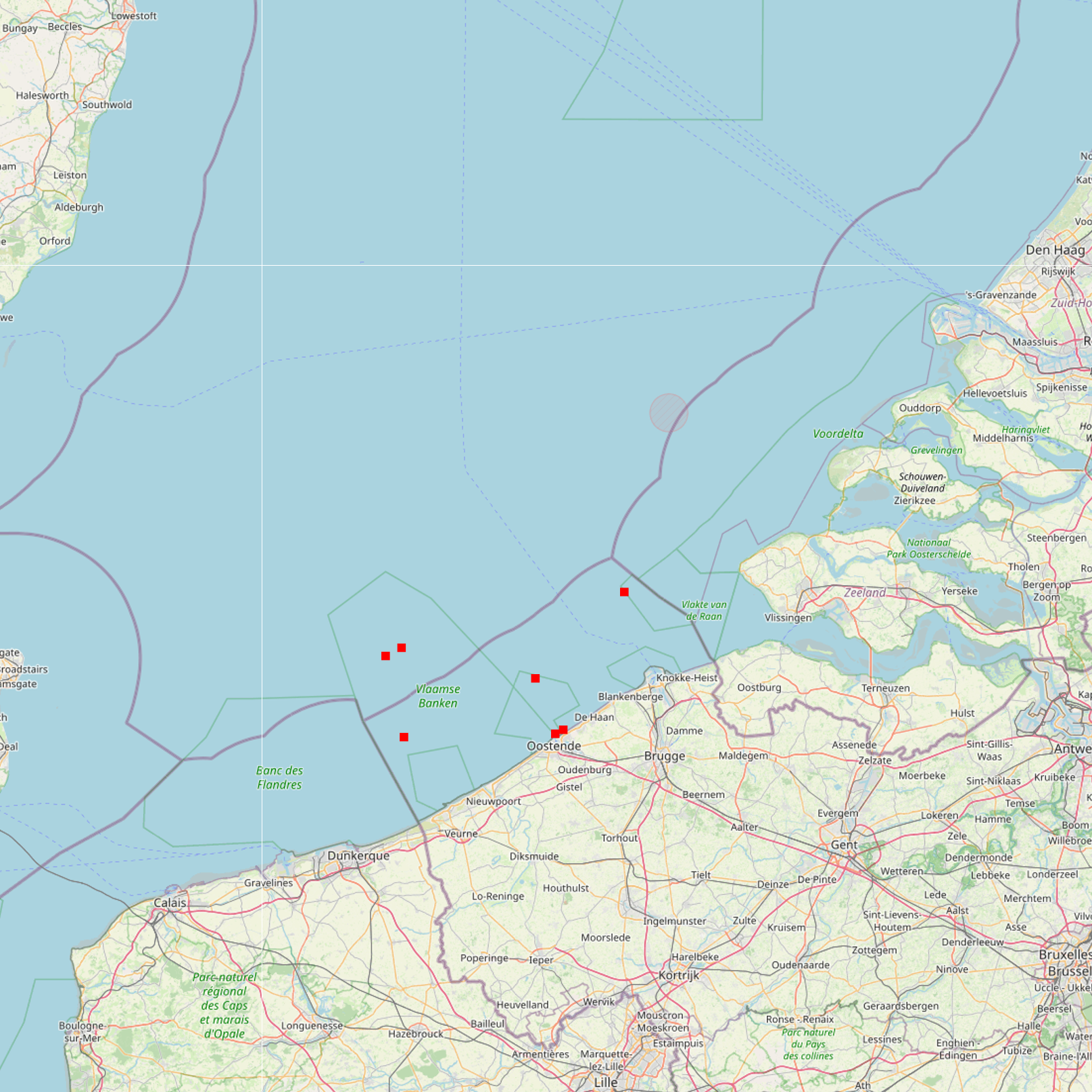
This dataset represents the exact location of active telecommunication cables (verified in 2010) installed in the Belgian Part of the North Sea.
-
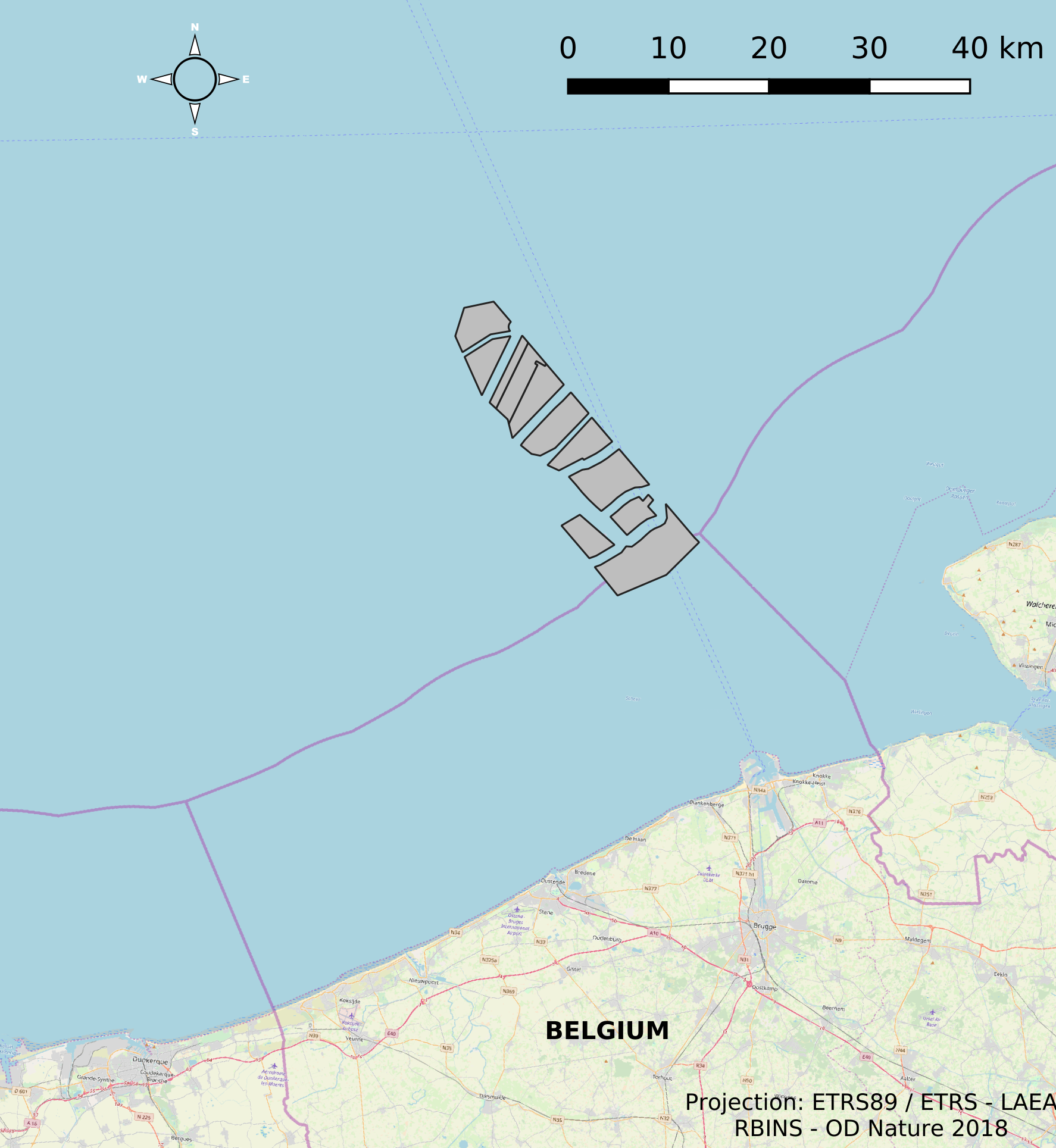
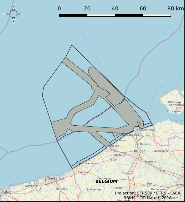
This dataset represents the location of the windfarms concessions in the Belgian Part of the North Sea.
-

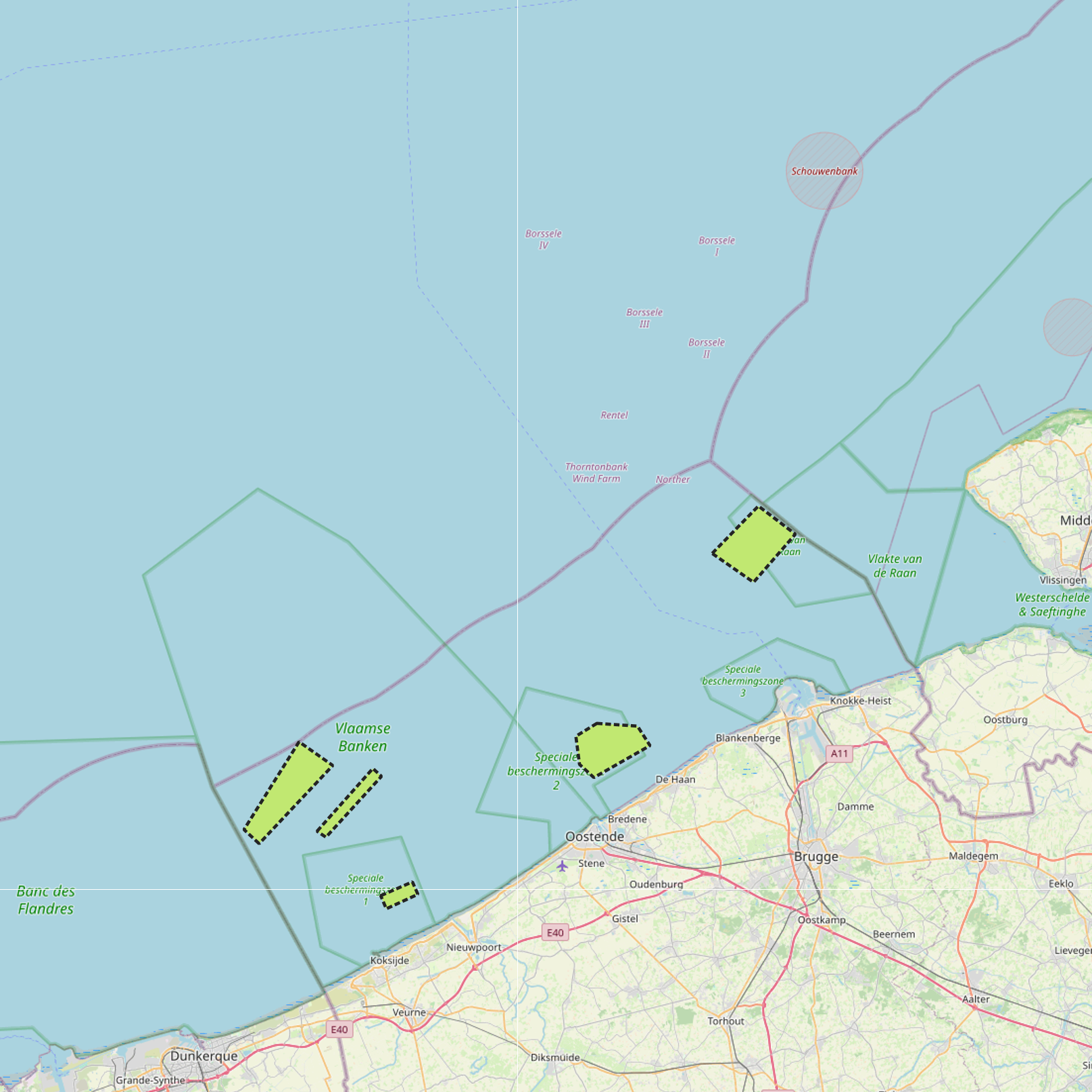
The Royal Decree of 22 May 2019 establishing a marine spatial plan defines in its Art. 11. five dredged material disposal sites (Dredged material disposal site S1, Art. 11 § 1.1°; Dredged material disposal site S2, Art. 11 § 1.2°; Dredged material disposal site Bruggen en Wegen Oostende, Art. 11 § 1.3°; Dredged material disposal site Bruggen en Wegen Zeebrugge Oost, Art. 11 § 1.4°; Dredged material disposal site Bruggen en Wegen Nieuwpoort, Art. 11 § 1.5°). Futhermore, additional zones are defined for the future replacement of dredging areas as defined in Art. 11 §3, §5, §7 and §9. It replaces the 2014 Marine Spatial Plan, which is included for completeness. The Royal Decree of 20 March 2014 establishing a marine spatial plan defines in its Art. 9. five dredged material disposal sites (Dredged material disposal site S1, Art. 9 § 6.1°; Dredged material disposal site S2, Art. 9 § 6.2°; Dredged material disposal site Bruggen en Wegen Oostende, Art. 9 § 6.3°; Dredged material disposal site Bruggen en Wegen Zeebrugge Oost, Art. 9 § 6.4°; Dredged material disposal site Bruggen en Wegen Nieuwpoort, Art. 9 § 6.5°). These zones are made available digitally in the resource described by this metadata document. Please refer to the Belgian official gazette (\"Moniteur belge/Belgisch Staatsblad\") for official reference information.
-

The Royal Decree of 22 May 2019 establishing a marine spatial plan defines 12 sand and gravel extraction zones: Sand and gravel exploitation sector 1a (Thorntonbank) (Art. 15§1), Sand and gravel exploitation sector 2br (Buiten Ratel) (Art. 15§1), Sand and gravel exploitation sector 2kb (Kwintebank) (Art. 15§1), Sand and gravel exploitation sector 2od (Oostdyck) (Art. 15§1), Sand and gravel exploitation sector 3a (Sierra Ventana) (Art. 15§1), Sand and gravel exploitation sector 3b (Sierra Ventana) (Art. 15§1), Sand and gravel exploitation sector 4a (Noordhinder) (Art. 15§1), Sand and gravel exploitation sector 4b (Oosthinder-noord) (Art. 15§1), Sand and gravel exploitation sector 4c (Oosthinder-zuid) (Art. 15§1), Sand and gravel exploitation sector 4d (Westhinder) (Art. 15§1), Sand and gravel exploitation sector 5 (Blighbank) (Art. 15§1), Zone for research of the potential of the exploration and exploitation of sand and gravel (Art. 15§4). It replaces the 2014 Marine Spatial Plan, which is included for completeness.. The Royal Decree of 20 March 2014 establishing a marine spatial plan defines in its Art. 11., eleven Management zones with regards to sand and gravel extraction: ten sand and gravel exploitation zones (Thorntonbank, Art. 11 § 1 Sector 1a, Kwintebank, Art. 11 § 1 Sector 2kb, Buiten Ratel, Art. 11 § 1 Sector 2br, Oostdyck, Art. 11 § 1 Sector 2od, Sierra Ventana, Art. 11 § 1 Sector 3a, Sierra Ventana, Art. 11 § 1 Sector 3b, Noord Hinder, Art. 11 § 1 Sector 4a, Oosthinder-noord, Art. 11 § 1 Sector 4b, Oosthinder-zuid, Art. 11 § 1 Sector 4c, Westhinder, Art. 11 § 1 Sector 4d) and one reference zone for monitoring impact of windmills and sand exploitation (Art. 11 § 3). These zones are made available digitally in the resource described by this metadata document. Please refer to the Belgian official gazette (\"Moniteur belge/Belgisch Staatsblad\") for official reference information.