 geo.be Metadata Catalog
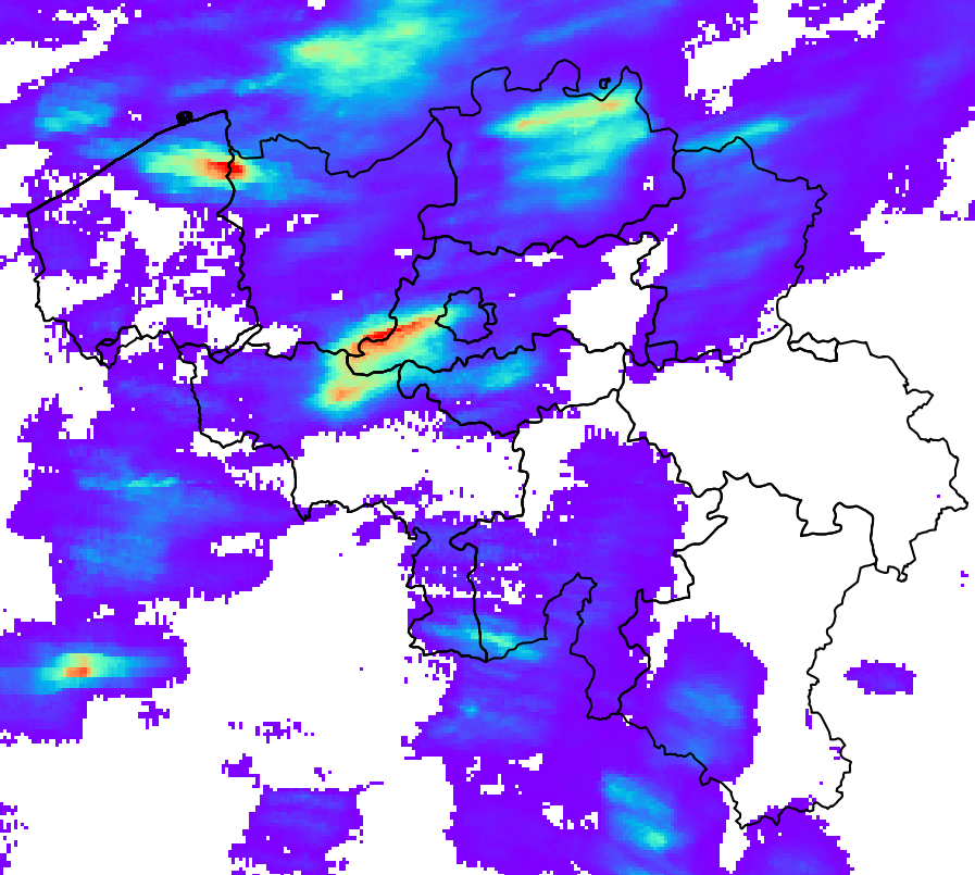
Schätzung der Niederschlagsmenge und -akkumulation in Belgien (QPE)
RADQPE bietet hochauflösende, radarbasierte quantitative Niederschlagsschätzungen in Echtzeit für Belgien und Umgebung.
Dieses Produkt ist noch nicht öffentlich verfügbar.
Simple
- Datum (Überarbeitung)
- 2026-03-10
- Identifikator
- RMI-be / qpe
- Bearbeitungsstatus
- Kontinuierliche Aktualisierung
- Überarbeitungsintervall
- Kontinuierlich
- GEMET - INSPIRE themes, version 1.0
-
- Atmosphärische Bedingungen
- Keywords Schlüsselwörter
-
- federal government
- radar
- observation
- rainfall
- Spatial scope
- Zugriffseinschränkungen
- Benutzerdeifinierte Einschränkungen
- Andere Einschränkungen
- Öffentliche Zugang nicht beschränkt
- Nutzungseinschränkungen
- Benutzerdeifinierte Einschränkungen
- Sicherheitseinstufung
- Unbeschränkt
- Räumliche Darstellungsart
- Raster, Gitter
- Distanz
- 1000 http://standards.iso.org/ittf/PubliclyAvailableStandards/ISO_19139_Schemas/resources /uom/ML_gmxUom.xml#m
- Sprache
- English
- Thematik
-
- Atmosphäre
))
- Anfangszeitpunkt
- 2018-05-01T00:00:00
- Code
- EPSG:4258
- Abgabeformat
-
-
HDF
(
5
)
-
HDF
(
5
)
- Online
-
KMI-Portal für offene Daten
(
WWW:LINK-1.0-http--link
)
KMI-Portal für offene Daten
- Bezugsebene
- Datenbestand
- Andere
- dataset
Konsistenz des Wertebereichs
- Testverfahren
- INSPIRE Conformity
Konformitätsergebnis
- Datum (Publikation)
- 2010-12-08
- Erklärung
- See the referenced specification
- Bestanden
- Nein
- Erläuterung
-
Das Produkt RADQPE wird nach einer sorgfältigen Verarbeitung der Wetterradarmessungen und einer Zusammenführung mit den Messungen der Regenmesser gewonnen. Die wissenschaftliche Grundlage findet sich in Goudenhoofdt und Delobbe (2016). Es gibt einen kontinuierlichen Verbesserungsprozess, der auf Forschung und Qualitätskontrolle basiert.
METEOROLOGISCHE RADARMESSUNGEN
Radargeräte senden elektromagnetische Impulse aus, die in der Regel eine Länge von 500 m und eine Breite von 1 Grad haben. Ein Teil der Energie dieses Impulses wird durch Niederschläge zum Radar zurückgeworfen. Radargeräte führen in etwa 5 Minuten Abtastungen in verschiedenen Höhen durch. Die Schätzung der Niederschläge anhand von Radarmessungen ist aufgrund zahlreicher Fehlerquellen und Unsicherheiten eine Herausforderung.
RADQPE basiert auf den 3D-Reflexionsmessungen der folgenden Radaranlagen:
- Avesnois, Frankreich, französischer Wetterdienst
- Helchteren, Belgien, flämische Umweltagentur
- Jabbeke, Belgien, Königlich-Belgisches Meteorologisches Institut
- Neuheilenbach, Deutschland, deutscher Wetterdienst
- Wideumont, Belgien, Königlich-Belgisches Meteorologisches Institut
Diese Radargeräte verfügen über unterschiedliche Technologien, Abtaststrategien und Datenverarbeitungsmethoden. Sie nutzen Doppler-Funktionen, um nicht meteorologische Echos ohne Geschwindigkeit (z. B. Hügel) zu eliminieren. Bestimmte Verarbeitungsmethoden können zu Informationsverlusten führen und die weitere Verarbeitung erschweren.
REGENMESSER
RADQPE verwendet die folgenden automatischen Regenmessernetzwerke:
- 91 gewichtete Regenmesser OTT2, SPWMI, Belgien
- 42 gewichtete Regenmesser OTT2, VMM, Belgien
- 19 gewichtete Regenmesser OTT2, WL, Belgien
Die Qualitätskontrolle durch die Datenlieferanten ist nicht vorhanden (WL), begrenzt (SPW) oder unbekannt (VMM). Vor dem Schreiben der Daten in die RMIB-Datenbank wird keine zusätzliche Qualitätskontrolle durchgeführt.
KONTROLLE DER RADARMESSUNGEN
- Identifizierung von ständig verfälschten Messungen (Hügel, Windparks, Interferenzen).
- Korrektur der Blockierung des Radarstrahls durch das Gelände
- Identifizierung von Störsignalen (d. h. Echos oder nicht meteorologische Signale) anhand von Satellitenprodukten zur Bewölkung
- Identifizierung von Störsignalen anhand vertikaler Profile der Radarreflektivität
- Identifizierung von Störsignalen anhand der Bildtextur
- Identifizierung von Störsignalen anhand der Doppelpolarisations-Technologie (nur Helchteren und Jabekke)
RADARMESSUNGEN ZUR SCHÄTZUNG DER NEDERLAßUNGSRATE AM BODEN
1. Identifizierung konvektiver Niederschläge
2. Extrapolation nicht-konvektiver Niederschläge auf den Boden anhand eines durchschnittlichen vertikalen Reflektivitätsprofils
3. Interpolation fehlender Daten (vertikal und anschließend horizontal)
4. Umrechnung der Reflektivität in Niederschlagsmenge je nach Niederschlagsart (Hagel, konvektiv, stratiform)
EINZIGE RADARAKKUMULATION UND BIAS-KORREKTUR
1. Die Bewegung der Niederschläge zwischen den 5-Minuten-Aufnahmen wird mithilfe von optischen Flussmethoden ermittelt. Sie wird verwendet, um die Niederschlagsraten der letzten Stunde und der letzten 24 Stunden zu akkumulieren.
2. Die Akkumulationen werden durch einen mittleren Feldbias (MFB) angepasst, der auf der Grundlage der Messungen der Regenmesser für denselben Zeitraum berechnet wird
3. Um Kalibrierungsunterschiede der Radargeräte vor der Zusammensetzung zu beseitigen, werden die Niederschlagsmengen eines einzelnen Radargeräts um den Median der Verzerrungen über 24 Stunden (berechnet im vorherigen Schritt) für den vergangenen Monat angepasst.
ZUSAMMENSETZUNG, AKKUMULATION UND ZUSAMMENFÜHRUNG VON RADAR UND REGENMESSER
1. In den Monaten, in denen konvektive Niederschläge vorherrschen (Mai, Juni, Juli, August), werden die Niederschlagsmengen der einzelnen Radargeräte zu einem Gesamtwert zusammengefasst, indem der Höchstwert der drei nächstgelegenen Radargeräte herangezogen wird.
2. In den übrigen Monaten basiert die Zusammensetzung auf allen Werten, die entsprechend ihrer Entfernung zum Radar gewichtet werden.
3. Die Niederschlagsakkumulation der zusammengesetzten Niederschlagsmengen erfolgt für die letzten 5 Minuten, die letzten 10 Minuten, die letzte Stunde und die letzten 24 Stunden.
4. Die zusammengesetzten Akkumulationen für 1 Stunde und 24 Stunden werden durch die MFB-Korrektur angepasst.
5. Die in der vorherigen Stufe vorgenommene Korrektur der Verzerrung über 1 Stunde wird auf die zusammengesetzte Niederschlagsrate angewendet. Die Korrektur wird auch auf die zusammengesetzten Niederschlagsmengen über 5 und 10 Minuten angewendet.
- Metadatensatzidentifikator
- RMI_DATASET_QPE XML
- Sprache
- English
- Hierarchieebene
- Datenbestand
- Datum
- 2026-03-10