 geo.be Metadata Catalog
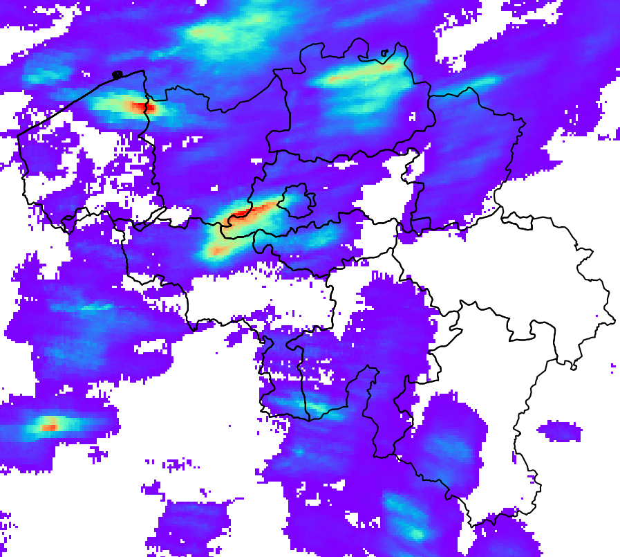
Estimation du taux de précipitations et de l'accumulation à la surface en Belgique (QPE)
RADQPE fournit en temps réel des estimations quantitatives de précipitations à haute résolution basées sur des données radar pour la Belgique et ses environs.
Ce produit n'est pas encore disponible au public.
Simple
- Date (Révision)
- 2026-03-10
- Identificateur
- RMI-be / qpe
- Etat
- Mise à jour continue
- Fréquence de mise à jour
- Continue
- GEMET - INSPIRE themes, version 1.0
-
- Conditions atmosphériques
- Mots clés
-
- federal government
- radar
- observation
- rainfall
- Spatial scope
- Contraintes d'accès
- Autres restrictions
- Autres contraintes
- Pas de restrictions concernant l'accès public
- Contraintes d'utilisation
- Autres restrictions
- Restrictions de manipulation
- Non classifié
- Type de représentation spatiale
- Raster
- Distance de résolution
- 1000 http://standards.iso.org/ittf/PubliclyAvailableStandards/ISO_19139_Schemas/resources /uom/ML_gmxUom.xml#m
- Langue
- English
- Catégorie ISO
-
- Climatologie/Météorologie/Atmosphère
))
- Date de début
- 2018-05-01T00:00:00
- Code
- EPSG:4258
- Format (encodage)
-
-
HDF
(
5
)
-
HDF
(
5
)
- Ressource en ligne
-
Portail de données ouvertes de l'IRM
(
WWW:LINK-1.0-http--link
)
Portail de données ouvertes de l'IRM
- Niveau
- Jeu de données
- Autre
- dataset
Cohérence du domaine de valeurs
- Nom du test
- INSPIRE Conformity
Résultat de conformité
- Date (Publication)
- 2010-12-08
- Explication
- See the referenced specification
- Degré de conformité
- Non
- Généralités sur la provenance
-
Le produit RADQPE est obtenu après un traitement minutieux des mesures du radar météorologique et une fusion avec les mesures des pluviomètres. La base scientifique se trouve dans Goudenhoofdt et Delobbe (2016). Il existe un processus d'amélioration continue basé sur la recherche et le contrôle de la qualité.
MESURES RADAR MÉTÉOROLOGIQUES
Les radars émettent des impulsions électromagnétiques, généralement d'une longueur de 500 m et d'une largeur de 1 degré. Une partie de l'énergie de cette impulsion est renvoyée vers le radar par les précipitations. Les radars effectuent des balayages à différentes altitudes en environ 5 minutes. L'estimation des précipitations à partir des mesures radar est un défi en raison des nombreuses sources d'erreur et d'incertitude.
RADQPE est basé sur les mesures de réflectivité 3D des radars suivants :
- Avesnois, France, Service météorologique national français
- Helchteren, Belgique, Agence flamande pour l'environnement
- Jabbeke, Belgique, Institut royal météorologique de Belgique
- Neuheilenbach, Allemagne, Service météorologique national allemand
- Wideumont, Belgique, Institut royal météorologique de Belgique
Ces radars présentent différentes technologies, stratégies de balayage et traitements des données. Ils utilisent les capacités Doppler pour éliminer les échos non météorologiques à vitesse nulle (par exemple, les collines). Certains traitements peuvent entraîner une perte d'informations et rendre difficile la poursuite du traitement.
MESURES DES PLUVIOMÈTRES
Les réseaux de pluviomètres automatiques suivants sont utilisés par RADQPE :
- 91 pluviomètres pondérés OTT2, SPWMI, Belgique
- 42 pluviomètres pondérés OTT2, VMM, Belgique
- 19 pluviomètres pondérés OTT2, WL, Belgique
Le contrôle qualité par les fournisseurs de données est nul (WL), limité (SPW) ou inconnu (VMM). Aucun contrôle qualité supplémentaire n'est effectué avant l'écriture des données dans la base de données RMIB.
CONTRÔLE DE LA QUALITÉ DES MESURES RADAR
- Identification des mesures contaminées en permanence (collines, parcs éoliens, interférences).
- Correction du blocage du faisceau radar par le terrain
- Identification des parasites (c'est-à-dire des échos ou des signaux non météorologiques) à partir des produits satellitaires sur la nébulosité
- Identification des parasites à partir des profils verticaux de la réflectivité radar
- Identification des parasites à partir de la texture de l'image
- Identification des parasites à partir de la technologie à double polarisation (uniquement Helchteren et Jabekke)
DES MESURES RADAR À L'ESTIMATION DU TAUX DE PRÉCIPITATIONS AU SOL
1. Identification des précipitations convectives
2. Extrapolation au sol des précipitations non convectives à l'aide d'un profil vertical moyen de réflectivité
3. Interpolation des données manquantes (verticalement puis horizontalement)
4. Conversion de la réflectivité en taux de pluie en fonction du type de précipitations (grêle, convectives, stratiformes)
ACCUMULATION RADAR UNIQUE ET CORRECTION DU BIAS
1. Le mouvement des précipitations entre les instantanés de 5 minutes est obtenu à l'aide de méthodes de flux optique. Il est utilisé pour accumuler les taux de pluie au cours de la dernière heure et des dernières 24 heures.
2. Les accumulations sont ajustées par un biais de champ moyen (MFB), qui est calculé sur la base des mesures des pluviomètres correspondant à la même durée
3. Afin d'éliminer les différences d'étalonnage des radars avant la composition, les taux de pluie d'un seul radar sont ajustés par la médiane des biais sur 24 heures (calculés à l'étape précédente) pour le mois écoulé.
COMPOSITION, ACCUMULATION ET FUSION RADAR-PLUVIOMÈTRE
1. Pour les mois où les précipitations convectives sont dominantes (mai, juin, juillet, août), les taux de pluie des radars individuels sont combinés en un composite en prenant la valeur maximale des 3 radars les plus proches.
2. Pour les autres mois, le composite est basé sur toutes les valeurs pondérées en fonction de la distance par rapport au radar.
3. L'accumulation des précipitations des taux de pluie composites est effectuée pour les 5 dernières minutes, 10 dernières minutes, 1 dernière heure et 24 dernières heures.
4. Les accumulations composites sur 1 heure et 24 heures sont ajustées par la correction MFB.
5. La correction du biais sur 1 heure de l'étape précédente est appliquée au taux de pluie composite. La correction est également appliquée aux accumulations composites sur 5 et 10 minutes.
- Identifiant de la fiche
- RMI_DATASET_QPE XML
- Langue
- English
- Type de ressource
- Jeu de données
- Date des métadonnées
- 2026-03-10