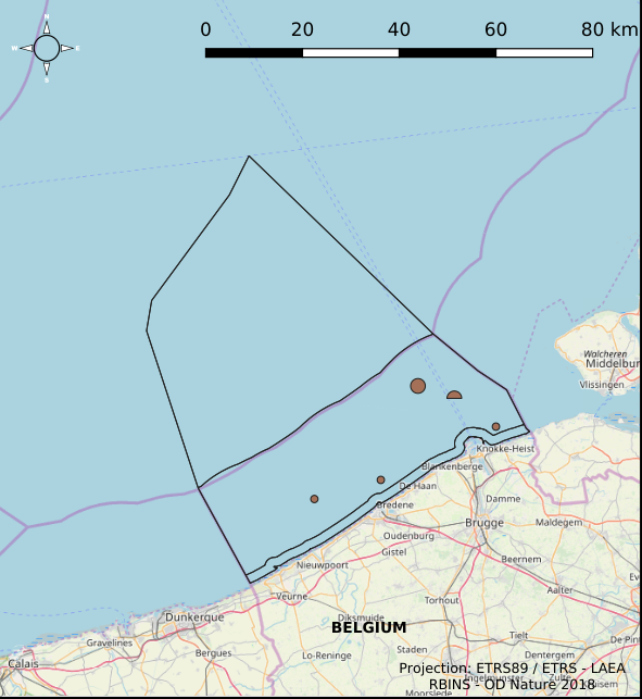
Baggergebiete im belgischen Teil der Nordsee
Simple
- Datum (Erstellung)
- 2021-11-18
- Datum (Überarbeitung)
- 2024-06-06
- Datum (Publikation)
- 2026-01-16
- Datum (Erstellung)
- 2016-05-19
- Identifikator
-
http://metadata.naturalsciences.be
/
f5606457-7084-41e3-b095-7730bc6adf10
- Datum
- Weitere Informationen
- This dataset is composed of the following sources: (1) Dredged material disposal sites in the Belgian Part of the North Sea. (2) MSP 2014-2020 Dredged material disposal sites in the Belgian Part of the North Sea. (3) MSP 2020-2026 Dredged material disposal sites in the Belgian Part of the North Sea. (4) SWAP (n.d.). MarineAtlas website.MarineAtlas website.
https://www.naturalsciences.be
https://www.bmdc.be
https://www.naturalsciences.be
https://odnature.naturalsciences.be/
- Thema
-
- Marine Spatial Plan
- Land use
- Reporting INSPIRE
- Bundesregierung
- Nutzungseinschränkungen
- Benutzerdeifinierte Einschränkungen
- Andere Einschränkungen
- No conditions apply to access and use
- Andere Einschränkungen
- https://creativecommons.org/licenses/by/4.0/
- Zugriffseinschränkungen
- Benutzerdeifinierte Einschränkungen
- Andere Einschränkungen
- Öffentliche Zugang nicht beschränkt.
- Anwendungseinschränkungen
- Es gelten keine Bedingungen zum Nutzung.
- Sicherheitseinstufung
- Unbeschränkt
- Räumliche Darstellungsart
- Vektor
- Sprache
- English
- Thematik
-
- Wirtschaft
- Meere
- Planungsunterlagen, Kataster
))
- Art der Ausdehnungsangabe
- Ja
- Datum
- Code
- North Sea
- gml32:beginPosition
- 2014-01-01
- Identifikator des Referenzsystems
- http://www.opengis.net/def/crs/EPSG/0/4258
- Abgabeformat
-
-
application/xml
(
Unknown
)
-
text/html
(
Unknown
)
-
application/xml
(
Unknown
)
Vertriebsstelle
https://www.bmdc.be
- Bezeichnung
- application/xml
- Version
- Unknown
- Transfergrösse
- 0.218439
- Online
-
imsp:bmsp_dredging_zone
(
OGC:WMS
)
A WMS service to view a map
Vertriebsstelle
https://www.bmdc.be
- Bezeichnung
- application/xml
- Version
- Unknown
- Transfergrösse
- 0.111594
- Online
-
imsp:bmsp_dredging_zone
(
OGC:WFS
)
A WFS service to download
Vertriebsstelle
https://www.bmdc.be
- Bezeichnung
- application/xml
- Version
- Unknown
- Transfergrösse
- 0.225898
- Online
-
imsp19:bmsp_dredging_zone
(
OGC:WMS
)
A WMS service to view a map
Vertriebsstelle
https://www.bmdc.be
- Bezeichnung
- application/xml
- Version
- Unknown
- Transfergrösse
- 0.116278
- Online
-
imsp19:bmsp_dredging_zone
(
OGC:WFS
)
A WFS service to download
Vertriebsstelle
https://www.bmdc.be
- Bezeichnung
- text/html
- Version
- Unknown
- Transfergrösse
- 0.008877
- Online
-
MarineAtlas website. SWAP
(
WWW:LINK-1.0-http--link
)
An HTTP link to view information
- Online
- Digital Object Identifier (DOI) ( DOI )
- Bezugsebene
- Datenbestand
Konformitätsergebnis
- Datum (Publikation)
- 2010-12-08
- Erklärung
- Siehe die angegebene Spezifikation
- Bestanden
- Ja
- Erläuterung
- Der Datensatz ist qualitätsgesichert. Der Datensatz entspricht einer digitalisierten Version der im belgischen Amtsblatt ("Belgisch staatsblad/Moniteur belge") veröffentlichten Informationen. Nur die im Amtsblatt veröffentlichten Informationen haben Rechtsgültigkeit.
- Metadatensatzidentifikator
- f5606457-7084-41e3-b095-7730bc6adf10 XML
- Sprache
- English
- Zeichensatz
- Utf8
- Hierarchieebene
- Datenbestand
- Datum
- 2026-01-16T16:13:07.535Z
- Bezeichnung des Metadatenstandards
- Geographic information -- Metadata
- Version des Metadatenstandards
- ISO 19115:2003/19139
 geo.be Metadata Catalog

