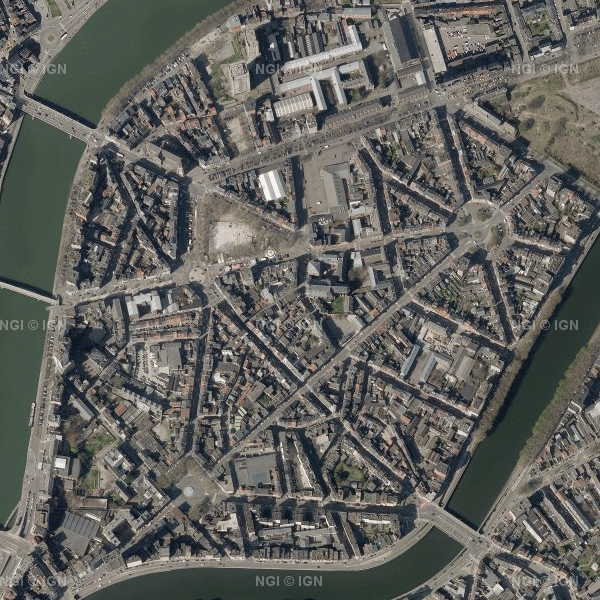
Orthophoto
Orthophotos are digital aerial photographs in which the systematic distortions caused by the central projection, terrain relief and an image acquisition axis that is not always perfectly vertical have been corrected. The national orthophoto coverage is renewed annually.
This dataset always contains the most recent operational orthophoto mosaics for the entire territory of Belgium. When the most recent acquisition campaign does not provide full coverage, the dataset is composed of the last one or two campaigns. In the current version of the dataset, the most recent national orthophoto coverage consists of a combination of the 2023 and 2024 campaigns.
The orthophotos have a spatial resolution of 25 cm in Wallonia and 12.5 cm in Flanders and the Brussels-Capital Region. The source data are supplied by the Belgian administrative Regions. NGI harmonises these regional datasets (geometrically and radiometrically) into a single national mosaic, georeferenced in Lambert 2008 (EPSG:3812) and tiled according to the MapIndex1 grid.
The dataset is INSPIRE-compliant and can be downloaded as compressed JPEG2000 files (JP2) per MapIndex1 tile, with the corresponding world file (.j2w) and metadata describing the extent of the tiles.
Simple
- Date (Creation)
- 2020-10-21
- Date (Revision)
- 2025-11-20
- Identifier
- BE.NGI-IGN / e59181f0-8469-44c6-8f6c-a5e1a4af15d5
- Status
- Completed
- Maintenance and update frequency
- Annually
- Belgian Federal Thesaurus
- Keywords
-
- HVD_cat_orthoimagery
- Use constraints
- Other restrictions
- Other constraints
- https://creativecommons.org/licenses/by/4.0/
- Access constraints
- Other restrictions
- Other constraints
- No limitations on public access
- Use limitation
- https://creativecommons.org/licenses/by/4.0/
- Spatial representation type
- Grid
- Distance
- 0.125 m
- Metadata language
- Deutsch
- Metadata language
- Nederlands; Vlaams
- Metadata language
- Français
- Character set
- 8859 Part 15
- Topic category
-
- Imagery base maps earth cover
- Description
- Belgium
))
- Unique resource identifier
- EPSG:3812
- Distribution format
-
-
jp2
()
-
jp2
()
- OnLine resource
- https://ac.ngi.be/remoteclient-open/GeoBePartners-open/ATOM/e59181f0-8469-44c6-8f6c-a5e1a4af15d5-en.xml ( INSPIRE Atom )
- OnLine resource
-
Direct download of resource orthophoto 2023 and 2024 (open data)
(
WWW:DOWNLOAD-1.0-http--download
)
Direct download of resource orthophoto 2023 and 2024 (open data)
- OnLine resource
-
Direct download of resource
(
WWW:DOWNLOAD-1.0-http--download
)
Direct download of resource
- OnLine resource
-
INSPIRE WMS
(
OGC:WMS
)
View service
- OnLine resource
-
https://ngi.be/aanbod/kaarten-en-fotos/luchtfotos-orthofotos/
(
WWW:LINK-1.0-http--link
)
Direct access to the webshop
- Hierarchy level
- Dataset
Domain consistency
- Name of measure
- INSPIRE Conformity
Conformance result
- Date (Publication)
- 2010-12-08
- Explanation
- The dataset’s compliance with the technical requirements as defined by the Commission Regulation (EU) No 1089/2010 of 23 November 2010 has not been checked
- Pass
- Yes
- Statement
- The orthophotos are available in geotiff lambert 2008 and are tiled according to the half-sheet map 1:10000. (see tiling description at orthophotos_gml_L08.zip)
- File identifier
- e59181f0-8469-44c6-8f6c-a5e1a4af15d5 XML
- Metadata language
- English
- Character set
- UTF8
- Hierarchy level
- Dataset
- Date stamp
- 2026-02-03T11:12:07
- Metadata standard name
- ISO 19115:2003/19139
- Metadata standard version
- 1.0
Overviews

Spatial extent
))
Provided by

 geo.be Metadata Catalog