 geo.be Metadata Catalog
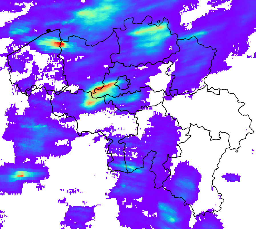
Schatting van de neerslaghoeveelheid en -accumulatie in België (QPE)
RADQPE biedt realtime kwantitatieve neerslagschattingen met hoge resolutie op basis van radargegevens voor België en omgeving.
Dit product is nog niet beschikbaar voor het grote publiek.
Standaard
- Datum (revisie)
- 2026-03-10
- Identifier
- RMI-be / qpe
- Status
- continu geactualiseerd
- Herzieningsfrequentie
- continu
- GEMET - INSPIRE themes, version 1.0
-
- Atmosferische omstandigheden
- Trefwoorden
-
- federal government
- radar
- observation
- rainfall
- Spatial scope
- (Juridische) toegangsrestrictie
- anders
- Overige beperkingen
- Geen beperkingen op openbare toegang
- (Juridische) gebruiksbeperking
- anders
- Veiligheidsrestricties
- vrij toegankelijk
- Ruimtelijk schema
- grid
- Afstand
- 1000 http://standards.iso.org/ittf/PubliclyAvailableStandards/ISO_19139_Schemas/resources /uom/ML_gmxUom.xml#m
- Taal
- English
- Onderwerp
-
- klimatologie, meteorologie atmosfeer
))
- Begindatum
- 2018-05-01T00:00:00
- Code
- EPSG:4258
- Distributie formaat
-
-
HDF
(
5
)
-
HDF
(
5
)
- OnLine bronnen
-
KMI open data portaal
(
WWW:LINK-1.0-http--link
)
KMI open data portaal
- Niveau kwaliteitsbeschrijving
- dataset
- Anders
- dataset
Domain consistentie
- Name of measure
- INSPIRE Conformity
Resultaat conformiteit met de specificatie
- Datum (publicatie)
- 2010-12-08
- Uitleg
- See the referenced specification
- Indicatie van conformiteit met de specificatie
- Nee
- Algemene beschrijving herkomst
-
Het RADQPE-product wordt verkregen na een zorgvuldige verwerking van de metingen van de weerradar en een samenvoeging met de metingen van de regenmeters. De wetenschappelijke basis hiervoor is te vinden in Goudenhoofdt en Delobbe (2016). Er is een proces van voortdurende verbetering op basis van onderzoek en kwaliteitscontrole.
METEOROLOGISCHE RADARMETINGEN
Radars zenden elektromagnetische pulsen uit, meestal met een lengte van 500 m en een breedte van 1 graad. Een deel van de energie van deze puls wordt door neerslag teruggekaatst naar de radar. Radars scannen verschillende hoogtes in ongeveer 5 minuten. Het schatten van neerslag op basis van radarmetingen is een uitdaging vanwege de vele bronnen van fouten en onzekerheden.
RADQPE is gebaseerd op 3D-reflectiviteitsmetingen van de volgende radars:
- Avesnois, Frankrijk, Franse nationale meteorologische dienst
- Helchteren, België, Vlaams Milieuagentschap
- Jabbeke, België, Koninklijk Meteorologisch Instituut van België
- Neuheilenbach, Duitsland, Duitse nationale meteorologische dienst
- Wideumont, België, Koninklijk Meteorologisch Instituut van België
Deze radars maken gebruik van verschillende technologieën, scanstrategieën en gegevensverwerkingstechnieken. Ze gebruiken Doppler-mogelijkheden om niet-meteorologische echo's met een snelheid van nul (bijvoorbeeld heuvels) te elimineren. Sommige verwerkingen kunnen leiden tot informatieverlies en de verdere verwerking bemoeilijken.
METINGEN VAN REGENMETERS
RADQPE maakt gebruik van de volgende netwerken van automatische regenmeters:
- 91 gewogen regenmeters OTT2, SPWMI, België
- 42 gewogen regenmeters OTT2, VMM, België
- 19 gewogen regenmeters OTT2, WL, België
De kwaliteitscontrole door de gegevensleveranciers is nihil (WL), beperkt (SPW) of onbekend (VMM). Er wordt geen aanvullende kwaliteitscontrole uitgevoerd voordat de gegevens in de RMIB-database worden opgeslagen.
KWALITEITSCONTROLE VAN RADARMETINGEN
- Identificatie van permanent vervuilde metingen (heuvels, windmolenparken, interferenties).
- Correctie van de blokkering van de radarstraal door het terrein
- Identificatie van storingen (d.w.z. echo's of niet-meteorologische signalen) op basis van satellietproducten over bewolking
- Identificatie van storingen op basis van verticale profielen van de radarreflectiviteit
- Identificatie van storingen op basis van de textuur van het beeld
- Identificatie van storingen op basis van dubbele polarisatietechnologie (alleen Helchteren en Jabekke)
RADARMETINGEN VOOR DE RAMING VAN DE NEERSLAGHOEVEELHEID OP DE GROND
1. Identificatie van convectieve neerslag
2. Extrapolatie naar de grond van niet-convectieve neerslag met behulp van een gemiddeld verticaal reflectiviteitsprofiel
3. Interpolatie van ontbrekende gegevens (verticaal en vervolgens horizontaal)
4. Omzetting van de reflectiviteit in neerslaghoeveelheid op basis van het type neerslag (hagel, convectief, stratiform)
UNIEKE RADARACCUMULATIE EN BIASCORRECTIE
1. De beweging van de neerslag tussen de 5 minuten durende momentopnames wordt verkregen met behulp van optische fluxmethoden. Deze wordt gebruikt om de neerslaghoeveelheden van het afgelopen uur en de afgelopen 24 uur te accumuleren.
2. De accumulaties worden gecorrigeerd door een gemiddelde veldbias (MFB), die wordt berekend op basis van de metingen van regenmeters die overeenkomen met dezelfde duur
3. Om verschillen in radarkalibratie vóór de samenstelling te elimineren, worden de neerslaghoeveelheden van een enkele radar aangepast met de mediaan van de afwijkingen over 24 uur (berekend in de vorige stap) voor de afgelopen maand.
SAMENSTELLING, ACCUMULATIE EN SAMENVOEGING RADAR-REGENMETER
1. Voor de maanden waarin convectieve neerslag overheerst (mei, juni, juli, augustus), worden de regenvalcijfers van de afzonderlijke radars samengevoegd tot een composiet door de maximale waarde van de 3 dichtstbijzijnde radars te nemen.
2. Voor de andere maanden is de composiet gebaseerd op alle waarden, gewogen naar afstand tot de radar.
3. De accumulatie van de neerslag van de composiet regenval wordt uitgevoerd voor de laatste 5 minuten, de laatste 10 minuten, het laatste uur en de laatste 24 uur.
4. De composiet accumulaties over 1 uur en 24 uur worden aangepast door de MFB-correctie.
5. De correctie van de vertekening over 1 uur uit de vorige stap wordt toegepast op de samengestelde neerslaghoeveelheid. De correctie wordt ook toegepast op de samengestelde accumulaties over 5 en 10 minuten.