 geo.be Metadata Catalog
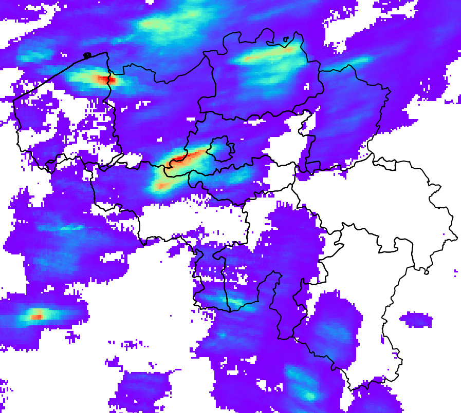
Schatting van de neerslaghoeveelheid en -accumulatie in België (QPE)
Estimation du taux de précipitations et de l'accumulation à la surface en Belgique (QPE)
Schätzung der Niederschlagsmenge und -akkumulation in Belgien (QPE)
RADQPE biedt realtime kwantitatieve neerslagschattingen met hoge resolutie op basis van radargegevens voor België en omgeving.
Dit product is nog niet beschikbaar voor het grote publiek.
RADQPE fournit en temps réel des estimations quantitatives de précipitations à haute résolution basées sur des données radar pour la Belgique et ses environs.
Ce produit n'est pas encore disponible au public.
RADQPE bietet hochauflösende, radarbasierte quantitative Niederschlagsschätzungen in Echtzeit für Belgien und Umgebung.
Dieses Produkt ist noch nicht öffentlich verfügbar.
Simple
-
Date (Révision)Datum (revisie)Datum (Überarbeitung)
- 2026-03-10
-
IdentificateurIdentifierIdentifikator
- RMI-be / qpe
-
EtatStatusBearbeitungsstatus
-
Mise à jour continuecontinu geactualiseerdKontinuierliche Aktualisierung
-
Fréquence de mise à jourHerzieningsfrequentieÜberarbeitungsintervall
-
ContinuecontinuKontinuierlich
- GEMET - INSPIRE themes, version 1.0
-
-
Atmosferische omstandighedenConditions atmosphériquesAtmosphärische Bedingungen
-
- Keywords
-
- federal government
- radar
- observation
- rainfall
- Spatial scope
-
Contraintes d'accès(Juridische) toegangsrestrictieZugriffseinschränkungen
-
Autres restrictionsandersBenutzerdeifinierte Einschränkungen
-
Overige beperkingenAutres contraintesAndere Einschränkungen
-
Geen beperkingen op openbare toegangPas de restrictions concernant l'accès publicÖffentliche Zugang nicht beschränkt
-
Contraintes d'utilisation(Juridische) gebruiksbeperkingNutzungseinschränkungen
-
Autres restrictionsandersBenutzerdeifinierte Einschränkungen
-
Restrictions de manipulationVeiligheidsrestrictiesSicherheitseinstufung
-
Non classifiévrij toegankelijkUnbeschränkt
-
Type de représentation spatialeRuimtelijk schemaRäumliche Darstellungsart
-
RastergridRaster, Gitter
-
Distance de résolutionAfstandDistanz
- 1000 http://standards.iso.org/ittf/PubliclyAvailableStandards/ISO_19139_Schemas/resources /uom/ML_gmxUom.xml#m
-
LangueTaalSprache
- English
-
Catégorie ISOOnderwerpThematik
-
-
Climatologie/Météorologie/Atmosphèreklimatologie, meteorologie atmosfeerAtmosphäre
-
))
- Begin date
- 2018-05-01T00:00:00
- Unique resource identifier
- EPSG:4258
-
Format (encodage)Distributie formaatAbgabeformat
-
-
HDF
(
5
)
-
HDF
(
5
)
-
Ressource en ligneOnLine bronnenOnline
-
KMI open data portaal Portail de données ouvertes de l'IRM KMI-Portal für offene Daten
(
WWW:LINK-1.0-http--link
)
KMI open data portaalPortail de données ouvertes de l'IRMKMI-Portal für offene Daten
-
NiveauNiveau kwaliteitsbeschrijvingBezugsebene
-
Jeu de donnéesdatasetDatenbestand
- Other
- dataset
Cohérence du domaine de valeurs
Domain consistentie
Konsistenz des Wertebereichs
- Name of measure
- INSPIRE Conformity
Résultat de conformité
Resultaat conformiteit met de specificatie
Konformitätsergebnis
-
Date (Publication)Datum (publicatie)Datum (Publikation)
- 2010-12-08
- Explanation
- See the referenced specification
-
Degré de conformitéIndicatie van conformiteit met de specificatieBestanden
- No
-
Algemene beschrijving herkomstGénéralités sur la provenanceErläuterung
-
Het RADQPE-product wordt verkregen na een zorgvuldige verwerking van de metingen van de weerradar en een samenvoeging met de metingen van de regenmeters. De wetenschappelijke basis hiervoor is te vinden in Goudenhoofdt en Delobbe (2016). Er is een proces van voortdurende verbetering op basis van onderzoek en kwaliteitscontrole.
METEOROLOGISCHE RADARMETINGEN
Radars zenden elektromagnetische pulsen uit, meestal met een lengte van 500 m en een breedte van 1 graad. Een deel van de energie van deze puls wordt door neerslag teruggekaatst naar de radar. Radars scannen verschillende hoogtes in ongeveer 5 minuten. Het schatten van neerslag op basis van radarmetingen is een uitdaging vanwege de vele bronnen van fouten en onzekerheden.
RADQPE is gebaseerd op 3D-reflectiviteitsmetingen van de volgende radars:
- Avesnois, Frankrijk, Franse nationale meteorologische dienst
- Helchteren, België, Vlaams Milieuagentschap
- Jabbeke, België, Koninklijk Meteorologisch Instituut van België
- Neuheilenbach, Duitsland, Duitse nationale meteorologische dienst
- Wideumont, België, Koninklijk Meteorologisch Instituut van België
Deze radars maken gebruik van verschillende technologieën, scanstrategieën en gegevensverwerkingstechnieken. Ze gebruiken Doppler-mogelijkheden om niet-meteorologische echo's met een snelheid van nul (bijvoorbeeld heuvels) te elimineren. Sommige verwerkingen kunnen leiden tot informatieverlies en de verdere verwerking bemoeilijken.
METINGEN VAN REGENMETERS
RADQPE maakt gebruik van de volgende netwerken van automatische regenmeters:
- 91 gewogen regenmeters OTT2, SPWMI, België
- 42 gewogen regenmeters OTT2, VMM, België
- 19 gewogen regenmeters OTT2, WL, België
De kwaliteitscontrole door de gegevensleveranciers is nihil (WL), beperkt (SPW) of onbekend (VMM). Er wordt geen aanvullende kwaliteitscontrole uitgevoerd voordat de gegevens in de RMIB-database worden opgeslagen.
KWALITEITSCONTROLE VAN RADARMETINGEN
- Identificatie van permanent vervuilde metingen (heuvels, windmolenparken, interferenties).
- Correctie van de blokkering van de radarstraal door het terrein
- Identificatie van storingen (d.w.z. echo's of niet-meteorologische signalen) op basis van satellietproducten over bewolking
- Identificatie van storingen op basis van verticale profielen van de radarreflectiviteit
- Identificatie van storingen op basis van de textuur van het beeld
- Identificatie van storingen op basis van dubbele polarisatietechnologie (alleen Helchteren en Jabekke)
RADARMETINGEN VOOR DE RAMING VAN DE NEERSLAGHOEVEELHEID OP DE GROND
1. Identificatie van convectieve neerslag
2. Extrapolatie naar de grond van niet-convectieve neerslag met behulp van een gemiddeld verticaal reflectiviteitsprofiel
3. Interpolatie van ontbrekende gegevens (verticaal en vervolgens horizontaal)
4. Omzetting van de reflectiviteit in neerslaghoeveelheid op basis van het type neerslag (hagel, convectief, stratiform)
UNIEKE RADARACCUMULATIE EN BIASCORRECTIE
1. De beweging van de neerslag tussen de 5 minuten durende momentopnames wordt verkregen met behulp van optische fluxmethoden. Deze wordt gebruikt om de neerslaghoeveelheden van het afgelopen uur en de afgelopen 24 uur te accumuleren.
2. De accumulaties worden gecorrigeerd door een gemiddelde veldbias (MFB), die wordt berekend op basis van de metingen van regenmeters die overeenkomen met dezelfde duur
3. Om verschillen in radarkalibratie vóór de samenstelling te elimineren, worden de neerslaghoeveelheden van een enkele radar aangepast met de mediaan van de afwijkingen over 24 uur (berekend in de vorige stap) voor de afgelopen maand.
SAMENSTELLING, ACCUMULATIE EN SAMENVOEGING RADAR-REGENMETER
1. Voor de maanden waarin convectieve neerslag overheerst (mei, juni, juli, augustus), worden de regenvalcijfers van de afzonderlijke radars samengevoegd tot een composiet door de maximale waarde van de 3 dichtstbijzijnde radars te nemen.
2. Voor de andere maanden is de composiet gebaseerd op alle waarden, gewogen naar afstand tot de radar.
3. De accumulatie van de neerslag van de composiet regenval wordt uitgevoerd voor de laatste 5 minuten, de laatste 10 minuten, het laatste uur en de laatste 24 uur.
4. De composiet accumulaties over 1 uur en 24 uur worden aangepast door de MFB-correctie.
5. De correctie van de vertekening over 1 uur uit de vorige stap wordt toegepast op de samengestelde neerslaghoeveelheid. De correctie wordt ook toegepast op de samengestelde accumulaties over 5 en 10 minuten.
Le produit RADQPE est obtenu après un traitement minutieux des mesures du radar météorologique et une fusion avec les mesures des pluviomètres. La base scientifique se trouve dans Goudenhoofdt et Delobbe (2016). Il existe un processus d'amélioration continue basé sur la recherche et le contrôle de la qualité.
MESURES RADAR MÉTÉOROLOGIQUES
Les radars émettent des impulsions électromagnétiques, généralement d'une longueur de 500 m et d'une largeur de 1 degré. Une partie de l'énergie de cette impulsion est renvoyée vers le radar par les précipitations. Les radars effectuent des balayages à différentes altitudes en environ 5 minutes. L'estimation des précipitations à partir des mesures radar est un défi en raison des nombreuses sources d'erreur et d'incertitude.
RADQPE est basé sur les mesures de réflectivité 3D des radars suivants :
- Avesnois, France, Service météorologique national français
- Helchteren, Belgique, Agence flamande pour l'environnement
- Jabbeke, Belgique, Institut royal météorologique de Belgique
- Neuheilenbach, Allemagne, Service météorologique national allemand
- Wideumont, Belgique, Institut royal météorologique de Belgique
Ces radars présentent différentes technologies, stratégies de balayage et traitements des données. Ils utilisent les capacités Doppler pour éliminer les échos non météorologiques à vitesse nulle (par exemple, les collines). Certains traitements peuvent entraîner une perte d'informations et rendre difficile la poursuite du traitement.
MESURES DES PLUVIOMÈTRES
Les réseaux de pluviomètres automatiques suivants sont utilisés par RADQPE :
- 91 pluviomètres pondérés OTT2, SPWMI, Belgique
- 42 pluviomètres pondérés OTT2, VMM, Belgique
- 19 pluviomètres pondérés OTT2, WL, Belgique
Le contrôle qualité par les fournisseurs de données est nul (WL), limité (SPW) ou inconnu (VMM). Aucun contrôle qualité supplémentaire n'est effectué avant l'écriture des données dans la base de données RMIB.
CONTRÔLE DE LA QUALITÉ DES MESURES RADAR
- Identification des mesures contaminées en permanence (collines, parcs éoliens, interférences).
- Correction du blocage du faisceau radar par le terrain
- Identification des parasites (c'est-à-dire des échos ou des signaux non météorologiques) à partir des produits satellitaires sur la nébulosité
- Identification des parasites à partir des profils verticaux de la réflectivité radar
- Identification des parasites à partir de la texture de l'image
- Identification des parasites à partir de la technologie à double polarisation (uniquement Helchteren et Jabekke)
DES MESURES RADAR À L'ESTIMATION DU TAUX DE PRÉCIPITATIONS AU SOL
1. Identification des précipitations convectives
2. Extrapolation au sol des précipitations non convectives à l'aide d'un profil vertical moyen de réflectivité
3. Interpolation des données manquantes (verticalement puis horizontalement)
4. Conversion de la réflectivité en taux de pluie en fonction du type de précipitations (grêle, convectives, stratiformes)
ACCUMULATION RADAR UNIQUE ET CORRECTION DU BIAS
1. Le mouvement des précipitations entre les instantanés de 5 minutes est obtenu à l'aide de méthodes de flux optique. Il est utilisé pour accumuler les taux de pluie au cours de la dernière heure et des dernières 24 heures.
2. Les accumulations sont ajustées par un biais de champ moyen (MFB), qui est calculé sur la base des mesures des pluviomètres correspondant à la même durée
3. Afin d'éliminer les différences d'étalonnage des radars avant la composition, les taux de pluie d'un seul radar sont ajustés par la médiane des biais sur 24 heures (calculés à l'étape précédente) pour le mois écoulé.
COMPOSITION, ACCUMULATION ET FUSION RADAR-PLUVIOMÈTRE
1. Pour les mois où les précipitations convectives sont dominantes (mai, juin, juillet, août), les taux de pluie des radars individuels sont combinés en un composite en prenant la valeur maximale des 3 radars les plus proches.
2. Pour les autres mois, le composite est basé sur toutes les valeurs pondérées en fonction de la distance par rapport au radar.
3. L'accumulation des précipitations des taux de pluie composites est effectuée pour les 5 dernières minutes, 10 dernières minutes, 1 dernière heure et 24 dernières heures.
4. Les accumulations composites sur 1 heure et 24 heures sont ajustées par la correction MFB.
5. La correction du biais sur 1 heure de l'étape précédente est appliquée au taux de pluie composite. La correction est également appliquée aux accumulations composites sur 5 et 10 minutes.
Das Produkt RADQPE wird nach einer sorgfältigen Verarbeitung der Wetterradarmessungen und einer Zusammenführung mit den Messungen der Regenmesser gewonnen. Die wissenschaftliche Grundlage findet sich in Goudenhoofdt und Delobbe (2016). Es gibt einen kontinuierlichen Verbesserungsprozess, der auf Forschung und Qualitätskontrolle basiert.
METEOROLOGISCHE RADARMESSUNGEN
Radargeräte senden elektromagnetische Impulse aus, die in der Regel eine Länge von 500 m und eine Breite von 1 Grad haben. Ein Teil der Energie dieses Impulses wird durch Niederschläge zum Radar zurückgeworfen. Radargeräte führen in etwa 5 Minuten Abtastungen in verschiedenen Höhen durch. Die Schätzung der Niederschläge anhand von Radarmessungen ist aufgrund zahlreicher Fehlerquellen und Unsicherheiten eine Herausforderung.
RADQPE basiert auf den 3D-Reflexionsmessungen der folgenden Radaranlagen:
- Avesnois, Frankreich, französischer Wetterdienst
- Helchteren, Belgien, flämische Umweltagentur
- Jabbeke, Belgien, Königlich-Belgisches Meteorologisches Institut
- Neuheilenbach, Deutschland, deutscher Wetterdienst
- Wideumont, Belgien, Königlich-Belgisches Meteorologisches Institut
Diese Radargeräte verfügen über unterschiedliche Technologien, Abtaststrategien und Datenverarbeitungsmethoden. Sie nutzen Doppler-Funktionen, um nicht meteorologische Echos ohne Geschwindigkeit (z. B. Hügel) zu eliminieren. Bestimmte Verarbeitungsmethoden können zu Informationsverlusten führen und die weitere Verarbeitung erschweren.
REGENMESSER
RADQPE verwendet die folgenden automatischen Regenmessernetzwerke:
- 91 gewichtete Regenmesser OTT2, SPWMI, Belgien
- 42 gewichtete Regenmesser OTT2, VMM, Belgien
- 19 gewichtete Regenmesser OTT2, WL, Belgien
Die Qualitätskontrolle durch die Datenlieferanten ist nicht vorhanden (WL), begrenzt (SPW) oder unbekannt (VMM). Vor dem Schreiben der Daten in die RMIB-Datenbank wird keine zusätzliche Qualitätskontrolle durchgeführt.
KONTROLLE DER RADARMESSUNGEN
- Identifizierung von ständig verfälschten Messungen (Hügel, Windparks, Interferenzen).
- Korrektur der Blockierung des Radarstrahls durch das Gelände
- Identifizierung von Störsignalen (d. h. Echos oder nicht meteorologische Signale) anhand von Satellitenprodukten zur Bewölkung
- Identifizierung von Störsignalen anhand vertikaler Profile der Radarreflektivität
- Identifizierung von Störsignalen anhand der Bildtextur
- Identifizierung von Störsignalen anhand der Doppelpolarisations-Technologie (nur Helchteren und Jabekke)
RADARMESSUNGEN ZUR SCHÄTZUNG DER NEDERLAßUNGSRATE AM BODEN
1. Identifizierung konvektiver Niederschläge
2. Extrapolation nicht-konvektiver Niederschläge auf den Boden anhand eines durchschnittlichen vertikalen Reflektivitätsprofils
3. Interpolation fehlender Daten (vertikal und anschließend horizontal)
4. Umrechnung der Reflektivität in Niederschlagsmenge je nach Niederschlagsart (Hagel, konvektiv, stratiform)
EINZIGE RADARAKKUMULATION UND BIAS-KORREKTUR
1. Die Bewegung der Niederschläge zwischen den 5-Minuten-Aufnahmen wird mithilfe von optischen Flussmethoden ermittelt. Sie wird verwendet, um die Niederschlagsraten der letzten Stunde und der letzten 24 Stunden zu akkumulieren.
2. Die Akkumulationen werden durch einen mittleren Feldbias (MFB) angepasst, der auf der Grundlage der Messungen der Regenmesser für denselben Zeitraum berechnet wird
3. Um Kalibrierungsunterschiede der Radargeräte vor der Zusammensetzung zu beseitigen, werden die Niederschlagsmengen eines einzelnen Radargeräts um den Median der Verzerrungen über 24 Stunden (berechnet im vorherigen Schritt) für den vergangenen Monat angepasst.
ZUSAMMENSETZUNG, AKKUMULATION UND ZUSAMMENFÜHRUNG VON RADAR UND REGENMESSER
1. In den Monaten, in denen konvektive Niederschläge vorherrschen (Mai, Juni, Juli, August), werden die Niederschlagsmengen der einzelnen Radargeräte zu einem Gesamtwert zusammengefasst, indem der Höchstwert der drei nächstgelegenen Radargeräte herangezogen wird.
2. In den übrigen Monaten basiert die Zusammensetzung auf allen Werten, die entsprechend ihrer Entfernung zum Radar gewichtet werden.
3. Die Niederschlagsakkumulation der zusammengesetzten Niederschlagsmengen erfolgt für die letzten 5 Minuten, die letzten 10 Minuten, die letzte Stunde und die letzten 24 Stunden.
4. Die zusammengesetzten Akkumulationen für 1 Stunde und 24 Stunden werden durch die MFB-Korrektur angepasst.
5. Die in der vorherigen Stufe vorgenommene Korrektur der Verzerrung über 1 Stunde wird auf die zusammengesetzte Niederschlagsrate angewendet. Die Korrektur wird auch auf die zusammengesetzten Niederschlagsmengen über 5 und 10 Minuten angewendet.
-
Identifiant de la ficheMetadata IDMetadatensatzidentifikator
- RMI_DATASET_QPE XML
-
LangueTaalSprache
- English
-
Type de ressourceHierarchisch niveauHierarchieebene
-
Jeu de donnéesdatasetDatenbestand
-
Date des métadonnéesMetadata datumDatum
- 2026-03-10
Overviews
Spatial extent
Provided by
