 geo.be Metadata Catalog
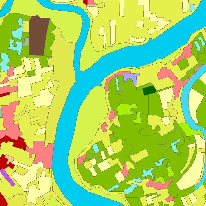
Riparian Zones
Riparian zones represent transitional areas occurring between land and freshwater ecosystems, characterised by distinctive hydrology, soil and biotic conditions and strongly influenced by the stream water. They provide a wide range of riparian functions (e.g. chemical filtration, flood control, bank stabilization, aquatic life and riparian wildlife support, etc.) and ecosystem services.
The Riparian Zones products will support the objectives of several European legal acts and policy initiatives, such as the EU Biodiversity Strategy to 2020, the Habitats and Birds Directives and the Water Framework Directive.
Two complementary product groups provide detailed information on the state and characteristics of riparian zones across Belgium:
1. Land Cover / Land Use (LCLU)
2. Green Linear Elements (GLE)
Simple
- Date (Creation)
- 2016-05-23
- Identifier
- EEA / 329c7e51-2557-11e9-b4a0-14abc58d5215
- Credit
-
Data was produced with funding by the European Union. Copyright Copernicus Programme
DISCLAIMER: National Geographic Institute has undertaken to distribute the data on behalf of EEA under Specific Contract No 3436/R0-Copernicus/EEA.57005 implementing Framework service contract No EEA/IDM/R0/16/009/Belgium. National Geographic Institute accepts no responsibility or liability whatsoever with regard to the content and use of these data.”
The European Environment Agency accepts no responsibility or liability whatsoever with regard to the information on this site and the information does not necessarily reflect the official opinion of the EEA or other European Communities bodies and institutions.
- Status
- Completed
- Maintenance and update frequency
- Unknown
- Keywords
-
- Riparian Zone
- Local
- 2012
- Copernicus
- HVD_cat_land use, HVD_cat_land cover
- Use limitation
- https://creativecommons.org/licenses/by/4.0/
- Access constraints
- Other restrictions
- Other constraints
- No limitations on public access
- Use constraints
- Other restrictions
- Other constraints
- https://creativecommons.org/licenses/by/4.0/
- Spatial representation type
- Vector
- Metadata language
- English
- Character set
- 8859 Part 15
- Topic category
-
- Environment
- Description
- Belgium
))
- Unique resource identifier
- EPSG:3812
- Codespace
- EPSG
- Distribution format
-
-
Esri Shapefile
(
)
-
Esri Shapefile
(
)
- OnLine resource
-
View service
(
OGC:WMS
)
View service
- OnLine resource
- https://land.copernicus.eu/local/riparian-zones ( WWW:LINK-1.0-http--link )
- OnLine resource
-
Downloadable data
(
WWW:DOWNLOAD-1.0-http--download
)
Downloadable data
- Hierarchy level
- Dataset
Domain consistency
- Name of measure
- INSPIRE Conformity
Conformance result
- Date (Publication)
- 2010-12-08
- Explanation
- The dataset described does not fill the technical requirements sustaining the interoperability of data sets and services, as stipulated in the Commission Regulation (EU) No 1089/2010 of 23 November 2010
- Pass
- No
- Statement
- Semi-automatic classification of 1.5m VHR2 SPOT-6 and 2.5m VHR2 SPOT-5 HRG satellite data from the DWH_MG2b_CORE_03 dataset (Optical VHR2 coverage over EU 2011-2013 and Riparian zones) and computer assisted visual refinement. Subsequently intersection of classification results with additional data (CLC 2006/2012, GIO HRL Tree Cover Density, Urban Atlas 2006/2012).
- File identifier
- 329c7e51-2557-11e9-b4a0-14abc58d5215 XML
- Metadata language
- English
- Character set
- UTF8
- Hierarchy level
- Dataset
- Date stamp
- 2026-02-03T11:13:01
- Metadata standard name
- ISO 19115:2003/19139
- Metadata standard version
- 1.0
Overviews
Spatial extent
Provided by