geo.be Metadata Catalog
Historical orthophotos 2000s (WMS)
Orthophotos historiques années 2000 (WMS)
Historische orthofoto’s jaren 2000 (WMS)
Historische Orthofotos 2000er Jahre (WMS)
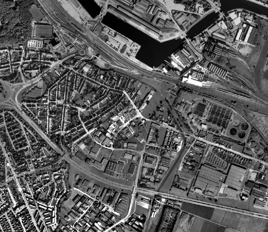
This service allows the visualization of historical orthophoto mosaics based on available aerial photographs covering parts of the Belgian territory. The data is accessible via a Web Map Service (WMS).
Orthophotos are aerial photographs that have been geometrically corrected (orthorectified) to eliminate distortions caused by terrain relief, lens distortion, and camera tilt. Unlike raw aerial imagery, orthophotos have a uniform scale and accurate geometry, making them suitable for cartography, measurements, and visual analysis.
This specific service includes historical orthophotos from 2000, 2001, 2002, 2003, 2004, 2005, 2006, 2007, 2008, and 2009, derived from aerial surveys carried out by the National Geographic Institute (NGI) and the Regions. From this period onward, both analogue and digital aerial photographs are available. The analogue images were scanned at high resolution and, like the digital ones, orthorectified. The resulting orthophotos were assembled into mosaics and georeferenced in the Lambert 2008 coordinate system.
The orthophotos are either panchromatic (black and white) or in colour (RGB), depending on the year and location. The ground resolution (GSD) varies between 10 cm and 100 cm, depending on the sensor used and the surveyed area. The spatial coverage of this service is limited to the areas for which aerial photographs were available during the mentioned period.
The service has been cached using the WebMercator TileMatrixSet, with a maximum scale denominator of 4,265.459167699568 metres (scale level 17).
Ce service permet la visualisation de mosaïques d’orthophotos historiques basées sur des photographies aériennes disponibles couvrant certaines parties du territoire belge. Les données sont accessibles via un Web Map Service (WMS).
Les orthophotos sont des photographies aériennes corrigées géométriquement (orthorectifiées) afin d’éliminer les déformations causées par le relief du terrain, les distorsions de l’objectif et l’inclinaison de la caméra. Contrairement aux images aériennes brutes, les orthophotos ont une échelle uniforme et une géométrie précise, ce qui les rend adaptées à la cartographie, aux mesures et à l’analyse visuelle.
Ce service spécifique comprend des orthophotos historiques des années 2000, 2001, 2002, 2003, 2004, 2005, 2006, 2007, 2008 et 2009, issues de campagnes aériennes réalisées par l’Institut Géographique National (IGN) et par les Régions. À partir de cette période, des photographies aériennes analogiques et numériques sont disponibles. Les images analogiques ont été numérisées en haute résolution et, tout comme les images numériques, orthorectifiées. Les orthophotos résultantes ont été assemblées en mosaïques et géoréférencées dans le système de coordonnées Lambert 2008.
Les orthophotos sont soit panchromatiques (noir et blanc), soit en couleur (RVB), selon l’année et l’emplacement. La résolution au sol (GSD) varie entre 10 cm et 100 cm, en fonction du capteur utilisé et de la zone survolée. La couverture spatiale de ce service est limitée aux zones pour lesquelles des photographies aériennes étaient disponibles durant la période mentionnée.
Le service a été mis en cache en utilisant le TileMatrixSet WebMercator, avec un dénominateur d’échelle maximal de 4 265,459167699568 mètres (niveau d’échelle 17).
Deze dienst maakt de visualisatie mogelijk van historische orthofotomozaïeken op basis van beschikbare luchtfoto’s van delen van het Belgische grondgebied. De gegevens zijn toegankelijk via een Web Map Service (WMS).
Orthofoto’s zijn luchtfoto’s die geometrisch zijn gecorrigeerd (orthorectificatie) om vervormingen veroorzaakt door reliëf, lensvervorming en camerahoek te elimineren. In tegenstelling tot ruwe luchtbeelden hebben orthofoto’s een uniforme schaal en nauwkeurige geometrie, waardoor ze geschikt zijn voor cartografie, metingen en visuele analyse.
Deze specifieke dienst omvat historische orthofoto’s uit 2000, 2001, 2002, 2003, 2004, 2005, 2006, 2007, 2008 en 2009, afkomstig van luchtopnamen uitgevoerd door het Nationaal Geografisch Instituut (NGI) en door de Gewesten. Vanaf deze periode zijn er zowel analoge als digitale luchtfoto’s beschikbaar. De analoge beelden werden in hoge resolutie gescand en, net als de digitale beelden, georthorectificeerd. De resulterende orthofoto’s werden samengevoegd tot mozaïeken en gegeorefereerd in het coördinatenstelsel Lambert 2008.
De orthofoto’s zijn panchromatisch (zwart-wit) of in kleur (RGB), afhankelijk van het jaar en de locatie. De grondresolutie (GSD) varieert tussen 10 cm en 100 cm, in functie van de gebruikte sensor en het opnamegebied. De ruimtelijke dekking van deze dienst is beperkt tot de zones waarvoor luchtfoto’s beschikbaar waren in de vermelde periode.
De service is gecached met behulp van de TileMatrixSet WebMercator, met een maximale schaalnoemer van 4 265,459167699568 meter (schaalniveau 17).
Dieser Dienst ermöglicht die Visualisierung historischer Orthofotomosaike auf Grundlage verfügbarer Luftbilder von Teilen des belgischen Staatsgebiets. Die Daten sind über einen Web Map Service (WMS) zugänglich.
Orthofotos sind Luftbilder, die geometrisch korrigiert (orthorektifiziert) wurden, um Verzerrungen durch Geländeerhebungen, Objektivverzerrungen und Kameraneigung zu beseitigen. Im Gegensatz zu unbearbeiteten Luftbildern verfügen Orthofotos über einen einheitlichen Maßstab und eine präzise Geometrie, wodurch sie sich für Kartografie, Vermessung und visuelle Analysen eignen.
Dieser spezifische Dienst umfasst historische Orthofotos aus den Jahren 2000, 2001, 2002, 2003, 2004, 2005, 2006, 2007, 2008 und 2009, die aus Luftaufnahmen des Nationalen Geographischen Instituts (NGI) und der Regionen stammen. Ab diesem Zeitraum sind sowohl analoge als auch digitale Luftbilder verfügbar. Die analogen Aufnahmen wurden hochauflösend gescannt und, ebenso wie die digitalen Bilder, orthorektifiziert. Die daraus resultierenden Orthofotos wurden zu Mosaiken zusammengefügt und im Koordinatensystem Lambert 2008 georeferenziert.
Die Orthofotos sind entweder panchromatisch (schwarz-weiß) oder farbig (RGB), je nach Jahr und Standort. Die Bodenauflösung (GSD) variiert zwischen 10 cm und 100 cm, abhängig vom verwendeten Sensor und dem aufgenommenen Gebiet. Die räumliche Abdeckung dieses Dienstes ist auf jene Gebiete beschränkt, für die im genannten Zeitraum Luftbilder verfügbar waren.
Der Dienst wurde mithilfe des TileMatrixSet WebMercator gecacht, mit einem maximalen Maßstabsnenner von 4.265,459167699568 Metern (Maßstabsstufe 17).
Simple
-
Date (Création)Datum (creatie)Datumsangaben (Erstellung)Date (Creation)
- 2009-12-31
-
Date (Publication)Datum (publicatie)Datumsangaben (Publikation)Date (Publication)
- 2026-02-20
-
IdentificateurIdentifierIdentifikatorCitation identifier
- BE.NGI-IGN / 0d6b76d6-841f-11f0-8dcf-00be433d8c24
- Point of contact
-
Organisation name Individual name Electronic mail address Role National Geographic Institute
Institut Géographique National
Nationaal Geografisch Instituut
Nationales Geographisches Institut
Anke Bracke
GestionnairebeheerderVerwalterCustodian
-
Fréquence de mise à jourHerzieningsfrequentieÜberarbeitungsintervallMaintenance and update frequency
-
Lorsque nécessaireindien nodigBei BedarfAs needed
- Keywords
-
-
historical orthophotos, aerial photographs, 2000, 2001, 2002, 2003, 2004, 2005, 2006, 2007, 2008, 2009, panchromatic, black and white, RGB, 10 cm resolution, 25 cm resolution, 50 cm resolution, 100 cm resolution
orthophotos historiques, photographies aériennes, 2000, 2001, 2002, 2003, 2004, 2005, 2006, 2007, 2008, 2009, panchromatique, noir et blanc, RVB, résolution 10 cm, résolution 25 cm, résolution 50 cm, résolution 100 cm
historische orthofoto’s, luchtfoto’s, 2000, 2001, 2002, 2003, 2004, 2005, 2006, 2007, 2008, 2009, panchromatisch, zwart-wit, RGB, 10 cm resolutie, 25 cm resolutie, 50 cm resolutie, 100 cm resolutie
historische Orthofotos, Luftbilder, 2000, 2001, 2002, 2003, 2004, 2005, 2006, 2007, 2008, 2009, panchromatisch, schwarz-weiß, RGB, 10 cm Auflösung, 25 cm Auflösung, 50 cm Auflösung, 100 cm Auflösung
-
-
Contraintes d'utilisation(Juridische) gebruiksbeperkingNutzungseinschränkungenUse constraints
-
Autres restrictionsandersBenutzerdefinierte EinschränkungenOther restrictions
-
Other constraintsAutres contraintesOverige beperkingenAndere Einschränkungen
-
•The custodian of the resource holds the rights of property (including the rights of intellectual property) to the geographic files
•The custodian grants the user the right to use the data for his internal use.
•Commercial use of the data under any form is strictly forbidden
•Custodian’s name must be mentioned each time the data are being used publically.
• Le gestionnaire du jeu de données tel qu’il est défini plus haut possède les droits de propriété (y compris les droits de propriété intellectuelle) se rapportant aux fichiers.
• Le gestionnaire accorde au client le droit d’utiliser les données pour son usage interne.
• L’usage des données à des fins commerciales, sous quelque forme que ce soit, est formellement interdit.
• Le nom du gestionnaire doit apparaître lors de chaque utilisation publique des données.
•De beheerder van de bron bezit de eigendomsrechten (ook de rechten op de intellectuele eigendom) op de geografische bestanden
• De beheerder geeft de klant het recht de gegevens te gebruiken voor intern gebruik
•Het commercieel gebruik van de gegevens onder welke vorm dan ook is strikt verboden
•De naam van de beheerder moet elke keer vermeld worden als de gegevens publiek gebruikt worden.
•Der Datensatzverwalter wie höher beschrieben besitzt die Eigentumsrechte (geistiges Eigentum einbegriffen) über die Dateien.• Der Verwalter gewährt dem Kunden das Recht, die Daten intern zu benutzen.• Die Daten zu irgendwelchen kommerziellen Zwecken zu benutzen ist strikt verboten.• Der Name des Verwalters muss bei jeder öffentlichen Benutzung der Daten gemeldet werden.
-
Contraintes d'accès(Juridische) toegangsrestrictieZugriffseinschränkungenAccess constraints
-
Autres restrictionsandersBenutzerdefinierte EinschränkungenOther restrictions
-
Other constraintsAutres contraintesOverige beperkingenAndere Einschränkungen
-
No limitations on public accessPas de restrictions concernant l'accès publicGeen beperkingen op openbare toegangÖffentliche Zugang nicht beschränkt
-
Use limitationLimitation d'utilisationGebruiksbeperkingenAnwendungseinschränkungen
-
•The custodian of the resource holds the rights of property (including the rights of intellectual property) to the geographic files
•The custodian grants the user the right to use the data for his internal use.
•Commercial use of the data under any form is strictly forbidden
•Custodian’s name must be mentioned each time the data are being used publically.
• Le gestionnaire du jeu de données tel qu’il est défini plus haut possède les droits de propriété (y compris les droits de propriété intellectuelle) se rapportant aux fichiers.
• Le gestionnaire accorde au client le droit d’utiliser les données pour son usage interne.
• L’usage des données à des fins commerciales, sous quelque forme que ce soit, est formellement interdit.
• Le nom du gestionnaire doit apparaître lors de chaque utilisation publique des données.
•De beheerder van de bron bezit de eigendomsrechten (ook de rechten op de intellectuele eigendom) op de geografische bestanden
• De beheerder geeft de klant het recht de gegevens te gebruiken voor intern gebruik
•Het commercieel gebruik van de gegevens onder welke vorm dan ook is strikt verboden
•De naam van de beheerder moet elke keer vermeld worden als de gegevens publiek gebruikt worden.
-
Type de serviceService TypeArt des DienstesService Type
- view
-
DescriptionDescriptionOmschrijvingBeschreibung
-
Belgium
Belgique
België
Belgien
))
- Coupled Resource
-
Operation Name Scoped name Identifier GetCapabilities
c3594ed1-1d4c-11f1-856c-20c19bc9b64c
GetCapabilities
4939b2bc-2926-11f1-b23e-20c19bc9b64c
GetCapabilities
433748b4-292c-11f1-a769-20c19bc9b64c
GetCapabilities
2363a560-29ff-11f1-a24a-20c19bc9b64c
GetCapabilities
e866c4ac-29fe-11f1-a203-20c19bc9b64c
GetCapabilities
dcc83997-29fc-11f1-9907-20c19bc9b64c
GetCapabilities
946dd1dd-29fe-11f1-9d6d-20c19bc9b64c
GetCapabilities
380df80f-29fe-11f1-a136-20c19bc9b64c
-
Type de couplageCoupling typeArt der KopplungCoupling Type
-
ReserrétightEngTight
- Contains Operations
-
Operation Name Distributed Computing Platforms Connect Point GetCapabilities
https://wms.ngi.be/orthophotos_2000s/service?service=wms&version=1.3.0&request=getcapabilities
-
Ressource coupléeOperates onBezieht sich aufOperates On
- Distribution format
-
Name Version
Options de transfert numérique
Digitale leverings opties
Digitale Transferoptionen
Digital transfer options
- OnLine resource
-
Protocol Linkage Name OGC:WMS
https://wms.ngi.be/orthophotos_2000s/service?service=wms&version=1.3.0&request=getcapabilities
Options de transfert numérique
Digitale leverings opties
Digitale Transferoptionen
Digital transfer options
- OnLine resource
-
Protocol Linkage Name OGC:WMTS
https://wmts.ngi.be/orthophotos_2000s/1.0.0/WMTSCapabilities.xml
-
NiveauNiveau kwaliteitsbeschrijvingBezugsebeneHierarchy level
-
ServiceserviceServiceService
- Other
-
service
Cohérence du domaine de valeurs
Domain consistentie
Konsistenz des Wertebereichs
Domain consistency
-
Name of measureNom du testName of measureTestverfahren
-
INSPIRE Conformity
Conformité INSPIRE
INSPIRE Conformiteit
INSPIRE Konformität
Résultat de conformité
Resultaat conformiteit met de specificatie
Konformitätsergebnis
Conformance result
-
Date (Publication)Datum (publicatie)Datumsangaben (Publikation)Date (Publication)
- 2009-08-19
-
ExplanationExplicationUitlegErklärung
-
The service described does not meet the technical requirements as defined by the Commission Regulation (EC) No 976/2009 of 19 October 2009.
Le service décrit ne répond pas aux exigences techniques telles qu’elles sont définies par le Règlement (UE) n° 976/2009 de la Commission du 19 octobre 2009.
De beschreven service voldoet niet aan de technische vereisten zoals bepaald in de Verordening (EC) nr 976/2009 van de Commissie van 19 oktober 2009
Der beschriebene Dienst entspricht nicht den technischen Anforderungen wie bestimmt in der Verordnung (EG) Nr. 976/2009 der Kommission vom 19. Oktober 2009.
-
Degré de conformitéIndicatie van conformiteit met de specificatieBestandenPass
- No
Metadata
-
Identifiant de la ficheMetadata IDMetadatensatzidentifikatorFile identifier
- 0d6b76d6-841f-11f0-8dcf-00be433d8c24 XML
-
LangueTaalSpracheMetadata language
- English
-
Jeu de caractèresKaraktersetZeichensatzCharacter set
-
Utf8utf8Utf8UTF8
-
Type de ressourceHierarchisch niveauHierarchieebeneHierarchy level
-
ServiceserviceServiceService
- Hierarchy level name
-
Webmap Service
-
Date des métadonnéesMetadata datumDatumDate stamp
- 2026-06-10T13:06:42
-
Metadata standard name
-
ISO 19115:2003/19139
- Metadata standard version
-
1.0
- Metadata author
-
Organisation name Individual name Electronic mail address Role National Geographic Institute
Institut Géographique National
Nationaal Geografisch Instituut
Nationales Geographisches Institut
Floor Van Damme
Point de contactcontactpuntAnsprechpartnerPoint of contact
- Other language
-
Language Character encoding FrançaisFransFranzösischFrenchNéerlandais; flamandNederlands; VlaamsNiederländischDutch; FlemishAllemandDuitsDeutschGermanAnglaisEngelsEnglischEnglishUtf8utf8Utf8UTF8