 geo.be Metadata Catalog
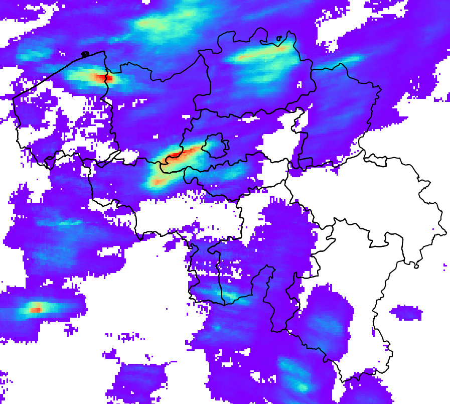
Belgian surface rainfall rate and accumulation estimation (QPE)
RADQPE provides high resolution radar-based quantitative precipitation estimation in realtime for Belgium and its surroundings.
This product is not publically available yet.
Simple
- Date (Revision)
- 2026-03-10
- Identifier
- RMI-be / qpe
- Status
- On going
- Maintenance and update frequency
- Continual
- GEMET - INSPIRE themes, version 1.0
-
- Atmospheric conditions
- Keywords
-
- federal government
- radar
- observation
- rainfall
- Spatial scope
- Access constraints
- Other restrictions
- Other constraints
- No limitations on public access
- Use constraints
- Other restrictions
- Classification
- Unclassified
- Spatial representation type
- Grid
- Distance
- 1000 http://standards.iso.org/ittf/PubliclyAvailableStandards/ISO_19139_Schemas/resources /uom/ML_gmxUom.xml#m
- Metadata language
- English
- Topic category
-
- Climatology, meteorology, atmosphere
))
- Begin date
- 2018-05-01T00:00:00
- Unique resource identifier
- EPSG:4258
- Distribution format
-
-
HDF
(
5
)
-
HDF
(
5
)
- OnLine resource
-
RMI open data portal
(
WWW:LINK-1.0-http--link
)
RMI open data portal
- Hierarchy level
- Dataset
- Other
- dataset
Domain consistency
- Name of measure
- INSPIRE Conformity
Conformance result
- Date (Publication)
- 2010-12-08
- Explanation
- See the referenced specification
- Pass
- No
- Statement
-
The RADQPE product is obtained after a careful processing of the weather radar measurements and a merging with rain gauge measurements. The scientific basis can be found in Goudenhoofdt and Delobbe (2016). There is a continuous improvement process based on research and quality control.
WEATHER RADAR MEASUREMENTS
Radars emit electromagnetic pulses, typically with a length of 500m and a width of 1 degree. Part of the energy of this pulse is reflected back to the radar by precipitation. Radars performs scans at different elevations in about 5 minutes. Estimating rainfall from radar measurements is a challenge because of the many sources of error and uncertainty.
RADQPE is based on the 3D reflectivity measurements of the following radars:
- Avesnois, France, French National Meteorological Service
- Helchteren, Belgium, Flanders Environment Agency
- Jabbeke, Belgium, The Royal Meteorological Institute of Belgium
- Neuheilenbach, Germany, German National Meteorological Service
- Wideumont, Belgium, The Royal Meteorological Institute of Belgium
These radars exhibit various technology, scanning strategy and data processing. They use Doppler capabilities to remove non-meteorological echoes with zero velocity (e.g. hills). Some processing can lead to loss of information and make further processing difficult.
RAIN GAUGE MEASUREMENTS
The following automatic rain gauge networks are used by RADQPE:
- 91 weighted gauge OTT2, SPWMI, Belgium
- 42 weighted gauge OTT2, VMM, Belgium
- 19 weighted gauge OTT2, WL, Belgium
The quality control by data providers is void (WL), limited (SPW) or unknown (VMM). No extra quality control is performed before writing the data in the RMIB database.
QUALITY CONTROL OF THE RADAR MEASUREMENTS
- Identification of permanently contaminated measurements (hills, wind farms, interference).
- Correction for radar beam blockage by terrain
- Identification of clutter (i.e. non-meteorological echoes or signals) based on satellite cloudiness products
- Identification of clutter based on vertical profiles of radar reflectivity
- Identification of clutter based on image texture
- Identification of clutter based on dual-polarisation technology (only Helchteren and Jabekke)
FROM RADAR MEASUREMENTS TO GROUND RAINFALL RATE ESTIMATION
1. Identification of convective precipitation
2. Extrapolation to ground of non convective precipitation using an averaged vertical profile of reflectivity
3. Interpolation of missing data (vertically then horizontally)
4. Conversion of reflectivity into rain rates based on precipitation type (hail, convective, stratiform)
SINGLE RADAR ACCUMULATION AND BIAS CORRECTION
1. The movement of precipitation between 5-min snapshots is obtained using optical flow methods. It is used to accumulate rain rates over the past 1 hour and 24 hours.
2. The accumulations are adjusted by a mean field bias (MFB), which is computed based on the rain gauges measurements corresponding to the same duration
3. To remove radar calibration difference before compositing, the single radar rain rates are adjusted by the median of the 24h biases (computed at the previous step) for the past month.
COMPOSITING, ACCUMULATION AND RADAR-GAUGE MERGING
1. For the months with dominant convective precipitation (May, June, July, August), the single radar rain rates are combined into a composite by taking the maximum value of the 3 closest radars.
2. For other months, the composite is based on all values weighted based on the distance to the radar.
3. Rainfall accumulation of the composite rain rates are made for the past 5 minutes, 10 minutes, 1 hour and 24 hours.
4. The 1h and 24h composite accumulations are adjusted by the MFB correction
5. The 1h bias correction of the previous step is applied to the composite rain rate. The correction is also applied to the 5 and 10-min composite accumulations
- File identifier
- RMI_DATASET_QPE XML
- Metadata language
- English
- Hierarchy level
- Dataset
- Date stamp
- 2026-03-10
Overviews
Spatial extent
Provided by
