 geo.be Metadata Catalog
Weermodel Alaro
Weermodel "Alaro"
Een numeriek voorspellingsmodel is een computerprogramma dat de ontwikkeling van de atmosfeer simuleert.
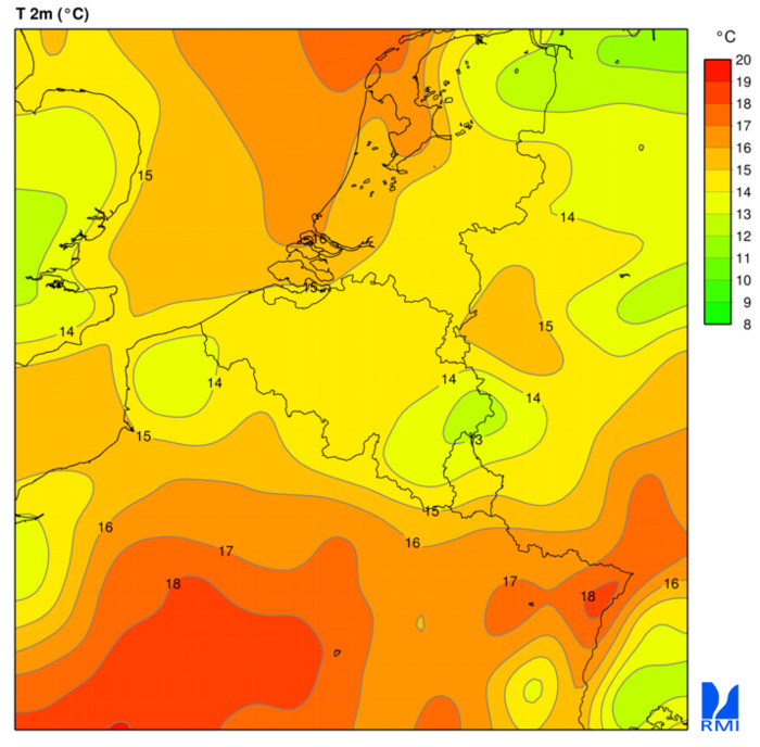
Beschikbare parameters: temperatuur, maximale temperatuur, minimale temperatuur, dauwpunttemperatuur, potentiële temperatuur van de natte bol, bewolking (laag, gemiddeld, hoog, totaal), U- en V-windcomponent, U- V en verticale snelheid, stationaire grenslaag (SBL) windvlaag, totale neerslag, grootschalige regen, convectieve regen, grootschalige sneeuw, convectieve sneeuw, relatieve vochtigheid, specifieke vochtigheid, geopotentiaal, gemiddelde zeeniveaudruk, orografie, vriespunt / 0 °C isotherm, convectieve beschikbare potentiële energie (CAPE).
Standaard
- Datum (creatie)
- 2010-01-01
- Identifier
- RMI-be / alaro
- Status
- continu geactualiseerd
- Herzieningsfrequentie
- continu
- GEMET - INSPIRE themes, version 1.0
-
- Atmosferische omstandigheden
- Trefwoorden
-
- Reporting INSPIRE
- federal government
- forecast
- temperature
- wind
- precipitation
- rain
- snow
- dewpoint temperature
- cloud cover
- relative humidity
- specific humidity
- geopotential
- pressure
- Spatial scope
- (Juridische) toegangsrestrictie
- anders
- Overige beperkingen
- Geen beperkingen op openbare toegang
- (Juridische) gebruiksbeperking
- anders
- Veiligheidsrestricties
- vrij toegankelijk
- Ruimtelijk schema
- grid
- Afstand
- 4000 http://standards.iso.org/ittf/PubliclyAvailableStandards/ISO_19139_Schemas/resources /uom/ML_gmxUom.xml#m
- Taal
- English
- Onderwerp
-
- klimatologie, meteorologie atmosfeer
))
- Begindatum
- 2010-01-01T12:00:00
- Code
- EPSG:4258
- Distributie formaat
-
-
Text/plain
(
1.0
)
-
Tiff
(
1.0
)
-
GeoTiff
(
1.0
)
-
Text/plain
(
1.0
)
- OnLine bronnen
-
KMI open data portaal
(
WWW:LINK-1.0-http--link
)
KMI open data portaal
- OnLine bronnen
-
WCS 1.1.0 getCapabilities-document
(
OGC:WCS-1.1.0-http-get-capabilities
)
WCS 1.1.0 getCapabilities-document
- OnLine bronnen
-
WMS 1.3.0 getCapabilities-document
(
OGC:WMS-1.3.0-http-get-capabilities
)
WMS 1.3.0 getCapabilities-document
- OnLine bronnen
-
FTP-map om Alaro GRIB-bestanden te downloaden. De laatste 4 runs zijn beschikbaar.
(
WWW:DOWNLOAD-1.0-ftp--download
)
FTP-map om Alaro GRIB-bestanden te downloaden. De laatste 4 runs zijn beschikbaar.
- OnLine bronnen
-
Documentatie
(
WWW:LINK-1.0-http--link
)
Documentatie
- Niveau kwaliteitsbeschrijving
- dataset
- Anders
- dataset
Domain consistentie
- Name of measure
- INSPIRE Conformity
Resultaat conformiteit met de specificatie
- Datum (publicatie)
- 2010-12-08
- Uitleg
- See the referenced specification
- Indicatie van conformiteit met de specificatie
- Nee
- Algemene beschrijving herkomst
-
De meeste weersvoorspellingen worden gemaakt door de informatie uit deze modellen te combineren met de expertise van de voorspeller.
De wetenschappers van het RMI proberen deze modellen voortdurend te verbeteren op basis van de nieuwste numerieke technieken, de parametrisering van fysische processen en het gebruik van meteorologische waarnemingen.
De resultaten van dit onderzoek worden verwerkt in het operationele weermodel ALARO. Dit model wordt gebruikt door de weersvoorspellers van het weerbureau en voor het creëren van producten en diensten voor het grote publiek.
Deze kaarten worden om de zes uur automatisch gegenereerd door ALARO. Ze worden niet gecorrigeerd of geïnterpreteerd door de voorspellers van het RMI. Voor een correcte interpretatie van deze kaarten is enige expertise vereist.
- Metadata ID
- RMI_DATASET_ALARO XML
- Taal
- English
- Hierarchisch niveau
- dataset
- Metadata datum
- 2025-09-25