 geo.be Metadata Catalog
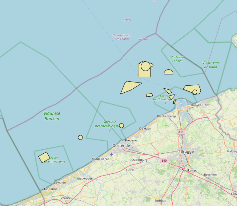
2026 Belgian MSP - Dredged material disposal sites
The Royal Decree of 20 March 2026 establishing the marine spatial plan for the period 2026 to 2034 in the Belgian marine areas defines 13 dredging zones: Dredge spoil disposal zone S1 (Art. 15§1.1°), Dredge spoil disposal zone S2 (Art. 15§1.2°), Dredge spoil disposal zone "Public Works Ostend" (Art. 15§1.3°), Dredge spoil disposal zone "Public Works Zeebrugge East" (Art. 15§1.4°), Dredge spoil disposal zone "Public Works Zeebrugge West" (Art. 15§1.5°), Dredge spoil disposal site "Public Works Nieuwpoort" (Art. 15§1.6°), Dredge spoil disposal zone "Zeebrugge Erosion Pit" (Art. 15§1.7°), Zone 1 for future replacement of dredge spoil zone S1 (Art. 15§4.1°), Zone 2 for future replacement of dredge spoil zone S1 (Art. 15§4.2°), Search zone 1 for future replacement of Zeebrugge East and West (Art. 15§6), Search zone 2 for future replacement of Zeebrugge East and West (Art. 15§6), Search zone 3 for future replacement of Zeebrugge East and West (Art. 15§6), Dredge spoil disposal zone for future replacement "Public Works Nieuwpoort" (Art. 15§8). It replaces the 2020 Marine Spatial Plan. Please refer to the Belgian official gazette ("Moniteur belgeBelgisch Staatsblad") for official reference information.
Standaard
- Datum (creatie)
- 2026-06-08
- Datum (revisie)
- 2026-06-18
- Datum (publicatie)
- 2026-07-22
- Datum (creatie)
- 2016-05-19
- Identifier
-
http://metadata.naturalsciences.be
/
bmdc.be:dataset:3120
- Datum
- Overige citatie details
- This dataset is composed of the following sources: MSP 2026-2032 Dredged material disposal sites.
beheerder
Koninklijk Belgisch Instituut voor Natuurwetenschappen (KBIN), Operationele Directie Natuurlijk Milieu (OD Natuur), Belgian Marine Data Centre (BMDC)
https://www.bmdc.be
https://www.bmdc.be
eigenaar
Koninklijk Belgisch Instituut voor Natuurwetenschappen (KBIN)
https://www.naturalsciences.be
https://www.naturalsciences.be
uitgever
Koninklijk Belgisch Instituut voor Natuurwetenschappen (KBIN)
https://www.naturalsciences.be
https://www.naturalsciences.be
- Trefwoorden
-
- Marine Spatial Plan
- Reporting INSPIRE
- Federale Overheid
- Land use
- (Juridische) gebruiksbeperking
- anders
- Overige beperkingen
- No conditions apply to access and use
- Overige beperkingen
- https://creativecommons.org/licenses/by/4.0/
- (Juridische) toegangsrestrictie
- anders
- Overige beperkingen
- Geen beperkingen op openbare toegang.
- Gebruiksbeperkingen
- Geen voorwaarden in verband met gebruik.
- Veiligheidsrestricties
- vrij toegankelijk
- Ruimtelijk schema
- vector
- Taal
- English
- Onderwerp
-
- economie
- oceanen
- planning kadaster
N
S
E
W
))
- gml32:beginPosition
- 2026-03-20
- Referentiesysteem identifier
- http://www.opengis.net/def/crs/EPSG/0/4258
- Distributie formaat
-
-
application/xml
(
Unknown
)
-
application/xml
(
Unknown
)
Distributeur
beheerder
Koninklijk Belgisch Instituut voor Natuurwetenschappen (KBIN), Operationele Directie Natuurlijk Milieu (OD Natuur), Belgian Marine Data Centre (BMDC)
https://www.bmdc.be
https://www.bmdc.be
- Naam
- application/xml
- Versie
- Unknown
- Bestands grootte
- 0.247716
- OnLine bronnen
-
imsp26:bmsp_dredging_zone
(
OGC:WMS
)
A WMS service to view a map
Distributeur
beheerder
Koninklijk Belgisch Instituut voor Natuurwetenschappen (KBIN), Operationele Directie Natuurlijk Milieu (OD Natuur), Belgian Marine Data Centre (BMDC)
https://www.bmdc.be
https://www.bmdc.be
- Naam
- application/xml
- Versie
- Unknown
- Bestands grootte
- 0.113308
- OnLine bronnen
-
imsp26:bmsp_dredging_zone
(
OGC:WFS
)
A WFS service to download
- OnLine bronnen
- Digital Object Identifier (DOI) ( DOI )
- Niveau kwaliteitsbeschrijving
- dataset
Resultaat conformiteit met de specificatie
- Datum (publicatie)
- 2010-12-08
- Uitleg
- Zie de gerefereerde specificatie
- Indicatie van conformiteit met de specificatie
- Ja
- Algemene beschrijving herkomst
- De kwaliteit van de dataset is gewaarborgd. De dataset komt overeen met een gedigitaliseerde versie van de informatie die in het Belgisch Staatsblad is gepubliceerd. Alleen de informatie die in het Belgisch Staatsblad wordt gepubliceerd, heeft rechtsgeldigheid.
- Metadata ID
- bmdc.be:dataset:3120 XML
- Taal
- English
- Karakterset
- utf8
- Hierarchisch niveau
- dataset
- Metadata datum
- 2026-07-22T15:32:29.337Z
- Metadata standaard naam.
- Geographic information -- Metadata
- Metadata standaard versie
- ISO 19115:2003/19139