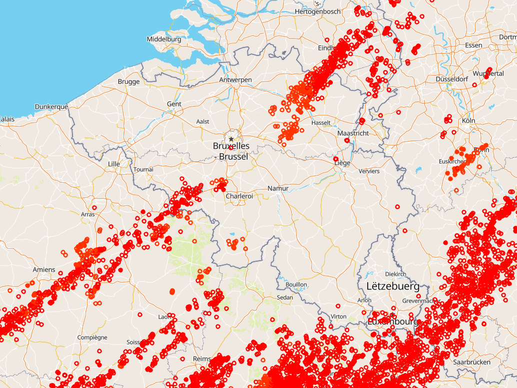
Belgisches Blitzortungssystem (BELLS)
Gesamtzahl der Blitzbeobachtungen, d. h. Wolke-Boden-Blitze (CG) und Intra-/Inter-Wolken-Impulse (IC) in Belgien. Die BELLS-Daten werden in Weltzeit angegeben! (Ortszeit Winter = UT +1; Ortszeit Sommer = UT + 2). Jeder Datensatz enthält folgende Felder:
1. Netzwerktyp, 0 = LF, 1 = VHF-TOA, 2 = VHF-ITF, 3 = VLF
2. Jahr, 1970 bis 2032.
3. Monat, wobei Januar als 1 und Dezember als 12 bezeichnet wird.
4. Tag des Monats, 1 bis 31.
5. Stunde, 0 bis 23.
6. Minute, 0 bis 59.
7. Sekunde, 0 bis 60.
8. Nanosekunde, 0 bis 999999999.
9. Breitengrad des berechneten Standorts in Dezimalgrad, auf 4 Dezimalstellen gerundet, -90,0 bis 90,0.
10. Längengrad des berechneten Standorts in Dezimalgrad, auf 4 Dezimalstellen gerundet, -180,0 bis 180,0.
11. Höhe in Metern, -4950 bis +60535. Dieses Feld ist 0, wenn die Höhe in den Blitzdaten nicht angegeben ist.
12. Die Höhenunsicherheit in Metern. Dieses Feld ist 0, wenn die Höhenunsicherheit in den Blitzdaten nicht angegeben ist.
13. Geschätzter Spitzenstrom in Kiloampere, -9999 bis 9999.
14. Normalisierte Leistung im VHF-Bereich, -9999,0 bis 9999,0
15. Multiplizität für Blitzdaten (1 bis 99) oder 0 für Blitzeinschläge.
16. Wolkenimpulszahl für die Blitzaufzeichnung. Dieses Feld hat den Wert -1, wenn der Blitz das Attribut „Wolkenimpulszahl” nicht enthält.
17. Anzahl der an der Lösung beteiligten Sensoren, 2 bis 99.
18. Freiheitsgrade bei der Standortoptimierung, 0 bis 99.
19. Der Fehlerellipsenwinkel als Peilung im Uhrzeigersinn von 0 Grad Nord, 0 bis 180,0 Grad
20. Die Länge der großen Halbachse der Fehlerellipse in Kilometern, 0 bis 50,0 km.
21. Die Länge der kleinen Halbachse der Fehlerellipse in Kilometern, 0 bis 50,0 km.
22. Chi-Quadrat-Wert aus der Standortoptimierung, 0 bis 999,99
23. Anstiegszeit der Wellenform in Mikrosekunden, 0 bis 99,9
24. Spitze-zu-Null-Zeit der Wellenform in Mikrosekunden, 0 bis 999,9
25. Maximale Anstiegsgeschwindigkeit der Wellenform in kA/usec (bei negativer Entladung negativer Wert), -999,9 bis 999,9
26. Wolkenanzeige, 1 bei Entladung zwischen Wolken, 0 bei Entladung zwischen Wolke und Boden
27. Winkelanzeige, 1, wenn Sensordaten zur Positionsberechnung verwendet wurden, andernfalls 0
28. Signalanzeige, 1, wenn Sensorsignaldaten zur Positionsberechnung verwendet werden, andernfalls 0
29. Zeitanzeige, 1, wenn Sensortimingdaten zur Positionsberechnung verwendet werden, andernfalls 0
30. Blitz-ID, ein eindeutiger ganzzahliger Wert, der die Blitzgruppe identifiziert, zu der ein Blitzschlag gehört, oder 0, wenn nicht festgelegt.
Dieses Produkt ist noch nicht öffentlich erhältlich.
Simple
- Datum (Überarbeitung)
- 2025-10-13
- Identifikator
- RMI-be / lightning
- Bearbeitungsstatus
- Kontinuierliche Aktualisierung
- GEMET - INSPIRE themes, version 1.0
-
- Atmosphärische Bedingungen
- Keywords Schlüsselwörter
-
- federal government
- observation
- lightning
- Spatial scope
- Zugriffseinschränkungen
- Benutzerdeifinierte Einschränkungen
- Andere Einschränkungen
- Öffentliche Zugang nicht beschränkt
- Nutzungseinschränkungen
- Benutzerdeifinierte Einschränkungen
- Sicherheitseinstufung
- Unbeschränkt
- Räumliche Darstellungsart
- Vektor
- Sprache
- English
- Thematik
-
- Atmosphäre
))
- Anfangszeitpunkt
- 1998-01-01T00:00:00
- Code
- EPSG:4258
- Abgabeformat
-
-
Text/plain
(
1.0
)
-
Text/plain
(
1.0
)
- Online
-
KMI-Portal für offene Daten
(
WWW:LINK-1.0-http--link
)
KMI-Portal für offene Daten
- Bezugsebene
- Datenbestand
- Andere
- dataset
Konsistenz des Wertebereichs
- Testverfahren
- INSPIRE Conformity
Konformitätsergebnis
- Datum (Publikation)
- 2010-12-08
- Erklärung
- See the referenced specification
- Bestanden
- Nein
- Erläuterung
- BELLS ist ein bodengestütztes Blitznetzwerk für niedrige Frequenzen. Die Blitzsensoren und der Zentralprozessor basieren auf der Technologie von Vaisala. Es werden nur Blitzaufzeichnungen berücksichtigt, die bestimmte Qualitätskriterien erfüllen, z. B. Länge der großen Halbachse, Mindestanzahl der beteiligten Sensoren.
- Metadatensatzidentifikator
- RMI_DATASET_LIGHTNING XML
- Sprache
- English
- Hierarchieebene
- Datenbestand
- Datum
- 2025-10-13
 geo.be Metadata Catalog

