 geo.be Metadata Catalog
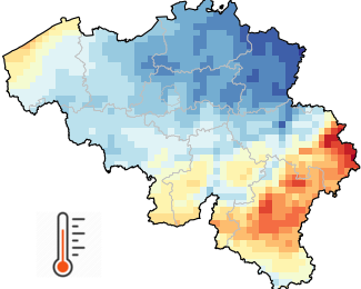
Gridded observational data
Gridded observational data provides an estimate of the spatial distribution of a meteorological variable based on observations. While instrumental measurements are taken at irregularly distributed stations, gridded data represents the meteorological variable on a predefined regular grid. Gridded observational data is of strong benefit in disciplines applying distributed quantitative models to examine the influence of weather and climate. Gridded data are also very convenient to provide estimations for any specific location of interest for the user.
Gridded observational data covering Belgium at a spatial resolution of 5 km (= 1360 pixels) are available for several variables (precipitations, air temperature, sunshine duration, solar radiation, relative humidity and wind speed) as well as different temporal resolutions (daily, monthly, seasonal, annual values as well as long-term climate averages).
The gridded database starts in 1961 for most variables and is updated each day with the available observations of the previous day. All grids are then updated for archiving as soon as the data quality control is completed.
In addition to the 5km x 5km grids, spatial averages for all each Belgian municipality are also available.
This product is not publically available yet.
The daily gridded climate data are available for academic profiles after registration on our open data website.
Simple
- Date (Revision)
- 2025-10-08
- Identifier
- RMI-be / griddedobs
- Status
- On going
- Maintenance and update frequency
- Daily
- GEMET - INSPIRE themes, version 1.0
-
- Meteorological geographical features
- Keywords
-
- Reporting INSPIRE
- federal government
- observation
- interpolated observations
- climate grids
- belgian municipalities
- air temperature
- precipitation
- wind speed
- solar radiation
- sunshine duration
- relative humidity
- Spatial scope
- Access constraints
- Other restrictions
- Other constraints
- No limitations on public access
- Use constraints
- Other restrictions
- Classification
- Unclassified
- Spatial representation type
- Grid
- Metadata language
- English
- Topic category
-
- Climatology, meteorology, atmosphere
))
- Begin date
- 1961-01-01T00:00:00
- Unique resource identifier
- EPSG:4258
- Distribution format
-
-
CSV
(
1.0
)
-
CSV
(
1.0
)
- OnLine resource
-
RMI open data portal
(
WWW:LINK-1.0-http--link
)
RMI open data portal
- Hierarchy level
- Dataset
- Other
- dataset
Domain consistency
- Name of measure
- INSPIRE Conformity
Conformance result
- Date (Publication)
- 2010-12-08
- Explanation
- See the referenced specification
- Pass
- No
- Statement
- The climate grids result from the spatial interpolation of observations. The interpolation method is adapted to each variable and temporal resolution. When possible, the involved statistical procedures integrate highly correlated ancillary data in addition to the observations. To cite a few examples, air temperature is affected by several factors such as the terrain elevation and the proximity of water surfaces. Solar radiation is mainly driven by cloud cover which can be characterized by Meteosat satellite data.
- File identifier
- RMI_DATASET_GRIDDEDOBS XML
- Metadata language
- English
- Hierarchy level
- Dataset
- Date stamp
- 2025-10-08
Overviews
Spatial extent
Provided by
