 geo.be Metadata Catalog
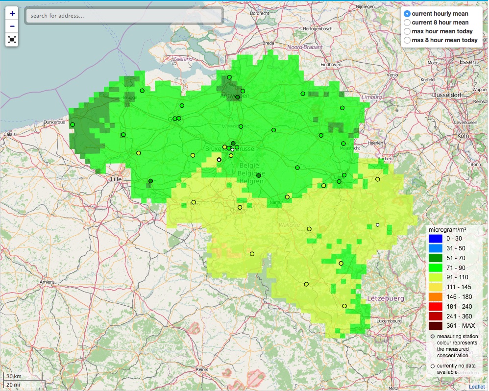
Interpolated air quality maps of Belgium
The air quality measurements are interpolated on a 4x4 km² grid using Corine Land Cover.
Simple
- Datum (Publikation)
- 2015-09-25
- Datum (Erstellung)
- 2014-09-25
- Identifikator
- rio:bc_hmean
- Identifikator
- rio:bc_24hmean
- Identifikator
- rio:bc_dmean
- Identifikator
- rio:no2_hmean
- Identifikator
- rio:no2_dmean
- Identifikator
- rio:o3_hmean
- Identifikator
- rio:o3_maxhmean
- Identifikator
- rio:o3_8hmean
- Identifikator
- rio:o3_max8hmean
- Identifikator
- rio:pm10_hmean
- Identifikator
- rio:pm10_24hmean
- Identifikator
- rio:pm10_dmean
- Identifikator
- rio:pm25_hmean
- Identifikator
- rio:pm25_24hmean
- Identifikator
- rio:pm25_dmean
- Identifikator
- rio:so2_hmean
Verwalter
Belgische Interregionale Umweltagentur (IRCEL - CELINE)
Rue Gaucheret 92
,
Brussels
,
1030
,
Belgien
http://www.irceline.be/
- GEMET - INSPIRE themes, version 1.0
-
- Atmospheric conditions
- GEMET - Concept themes, version 4.01
-
- air
- air quality
- air quality monitoring
- environmental policy
- environmental assessment
- pollutant assessment
- air quality management
- method
- evaluation method
- Keywords Schlüsselwörter
-
- Belgium
- Keywords Schlüsselwörter
-
- EU Directive 2008/50/EC
- Keywords Schlüsselwörter
-
- Dataflow E
- Keywords Schlüsselwörter
-
- Dataflow F
- Keywords Schlüsselwörter
-
- RIO 4x4
- Interregional
- EARTh- Enviromental Applications Reference THesaurus (Version: Linked Data 1.5)
-
- air policy
- monitoring stations
- EUROVOC (ver: 4.4)
-
- area management
- EU environmental policy
- monitoring of pollution
- Keywords Schlüsselwörter
-
- Reporting INSPIRE
- INSPIRE priority data set
-
- Measurement and modelling data (Air Quality Directive)
- Spatial scope
-
- National
- Nutzungseinschränkungen
- Benutzerdeifinierte Einschränkungen
- Andere Einschränkungen
- https://creativecommons.org/licenses/by/4.0/deed.de
- Anwendungseinschränkungen
- https://creativecommons.org/licenses/by/4.0/deed.de
- Zugriffseinschränkungen
- Benutzerdeifinierte Einschränkungen
- Andere Einschränkungen
- No limitations on public access
- Räumliche Darstellungsart
- Vektor
- Massstabszahl
- 1500000
- Sprache
- English
- Thematik
-
- Atmosphäre
N
S
E
W
))
- Anfangszeitpunkt
- 2014-01-01
- Endzeitpunkt
- 2014-12-31 Before
- Code
- EPSG:4258
- Namensraum
- EPSG
- Abgabeformat
-
-
GML
(
3.2.1
)
-
GML
(
3.2.1
)
- Transfergrösse
- 0
- Bezugsebene
- Datenbestand
Konformitätsergebnis
- Datum (Publikation)
- 2010-12-08
- Erklärung
- See the referenced specification
- Bestanden
- Nein
Konformitätsergebnis
- Datum (Publikation)
- 2011-12-12
- Erklärung
- See the referenced specification
- Bestanden
- Nein
- Erläuterung
- The dataset is created in the context of the 2008/50/EC Framework Directive. The Belgian territory is devided into zones according to the instructions listed in the 2008/50/EC Directive. The assessment methods are used to provide information for the assessment of air quality in Belgium towards the Commission. Member States shall make the information referred to in paragraph 1 available to the Commission for a full calendar year no later than 9 months after the end of each calendar year.
- Metadatensatzidentifikator
- 24c018e0-e9bd-4315-8e64-b9dbe724710c XML
- Sprache
- English
- Zeichensatz
- Utf8
- Hierarchieebene
- Datenbestand
- Datum
- 2024-12-03T15:19:07
- Bezeichnung des Metadatenstandards
- ISO19115
- Version des Metadatenstandards
- 2003/Cor.1:2006
Ansprechpartner
Belgische Interregionale Umweltagentur (IRCEL - CELINE)
Rue Gaucheret 92
,
Brussels
,
1030
,
Belgien
http://www.irceline.be/