 geo.be Metadata Catalog
Hillshade
Simple
- Date (Creation)
- 2019-09-18
- Date (Revision)
- 2019-09-18
- Identifier
- BE.NGI-IGN / d48e0a40-d6a1-11ec-bb3a-186571a04de2
- Status
- Completed
- Maintenance and update frequency
- As needed
- Keywords
-
- HVD_cat_elevation
- Use constraints
- Other restrictions
- Other constraints
- https://creativecommons.org/licenses/by/4.0/
- Access constraints
- Other restrictions
- Other constraints
- No limitations on public access
- Use limitation
- https://creativecommons.org/licenses/by/4.0/
- Spatial representation type
- Grid
- Distance
- 10000 m
- Metadata language
- Français
- Metadata language
- Nederlands; Vlaams
- Character set
- 8859 Part 15
- Topic category
-
- Elevation
- Description
- Belgium
))
- Unique resource identifier
- EPSG:3812
- Distribution format
-
-
TIFF
()
-
Esri Geodatabase
()
-
TIFF
()
- OnLine resource
-
https://www.ngi.be/website/contact
Order by mail
- OnLine resource
-
https://ac.ngi.be/remoteclient-open/ngi-standard-open/Specifications/Rasterdata/ombrages_spectech_EN.pdf
(
WWW:LINK-1.0-http--link
)
technical specifications of the product
- Hierarchy level
- Dataset
Domain consistency
- Name of measure
- INSPIRE Conformity
Conformance result
- Date (Publication)
- 2010-12-08
- Explanation
- The dataset’s compliance with the technical requirements as defined by the Commission Regulation (EU) No 1089/2010 of 23 November 2010 has not been checked
- Statement
-
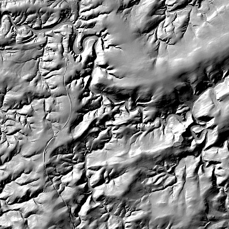
The 'Hillshade' product is a hillshading view of DTMs at different resolutions. The source data used for the production of this 'Shading' product are the DTMs at 1m, 5m or 20m resolution.
To create this view, we used the following parameters:
- Azimuth: 315° (angle of the fictitious light source to North)
- Altitude: 45° (angle of the dummy light source above the horizon)
Hillshading views allow for the creation of a graphic shading effect that gives an idea of the terrain relief on the map representations.
- File identifier
- d48e0a40-d6a1-11ec-bb3a-186571a04de2 XML
- Metadata language
- English
- Character set
- UTF8
- Hierarchy level
- Dataset
- Date stamp
- 2026-02-03T11:28:49
- Metadata standard name
- ISO 19115:2003/19139
- Metadata standard version
- 1.0
Overviews
Spatial extent
Provided by