geo.be Metadata Catalog
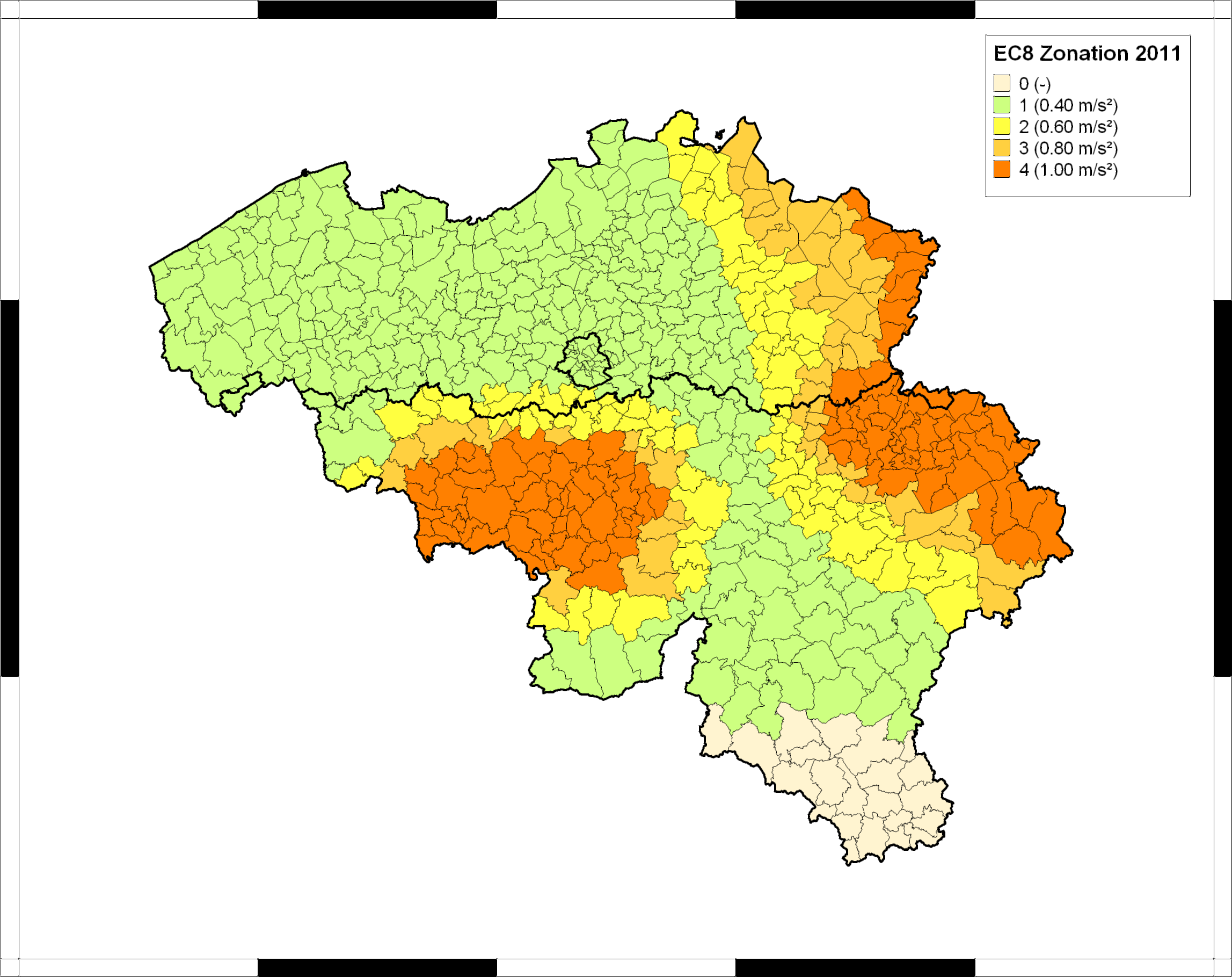
EUROCODE 8 Seismic Zoning Map for Belgium
The seismic zoning map for Belgium was published in the Belgian national annex (NBN EN 1998-1 ANB) to the European building code Eurocode 8 (EN 1998-1), which became effective in all European member states in 2011. This map classifies Belgian communes into five seismic zones, corresponding to different values of the reference peak ground acceleration (PGA) to be taken into account in the design of structures for earthquake resistance. In combination with the importance class of the building and the ground type, the reference PGA is used to calculate the design response spectrum defining the accelerations that the structure should be able to withstand without collapse. For further details and the precise specifications, users should consult the normative documents, which can be ordered from the Bureau for Standardisation NBN (https://www.nbn.be/en).
The Eurocode-8 seismic zoning map for Belgium was established by the Royal Observatory of Belgium, based on a reimplementation of the seismic hazard map of Leynaud et al. (2000) for a return period of 475 years (equivalent to 10% probability of exceedance in a timespan of 50 years). This hazard map was calculated following the principles of probabilistic seismic hazard assessment, and based on a simple model of seismic sources and their activity in and around Belgium, and a single ground-motion model (or “attenuation law”), describing PGA in function of earthquake magnitude and epicentral distance. To date, this is the only seismic hazard map that has been published specifically for Belgium, and it is still considered as the official seismic hazard map for Belgium.
Simple
- Date (Creation)
- 2016-10-29T16:00:00
Identifier
- Identifier
- BE.KSB-ORB / 26926de1-5ef4-47ee-b59d-bee0d9e6acee
- Status
- Completed
- Maintenance and update frequency
- Not planned
- Theme
-
- Earthquakes
- Federal government
- Place
-
- Belgium
- Use constraints
- Other restrictions
- Other constraints
- Copyright has to be respected. You can find detailed information here: http://seismologie.oma.be/en/legal-notices/data-policy
- Access constraints
- Other restrictions
- Other constraints
- No limitations on public access
- Spatial representation type
- Vector
- Denominator
- 250000
- Metadata language
- English
- Character set
- UTF8
- Topic category
-
- Location
- Geoscientific information
- Begin date
- 2009-01-01
))
- Unique resource identifier
- EPSG:4326
- Codespace
- EPSG
- Distribution format
-
-
Esri Shapefile
(
)
-
Esri Shapefile
(
)
- OnLine resource
-
View service
(
OGC:WMS
)
View service
- OnLine resource
-
Download service
(
OGC:WFS
)
Download service
- OnLine resource
-
Downloadable data
(
WWW:DOWNLOAD-1.0-http--download
)
Downloadable data
- Hierarchy level
- Dataset
- Dataset
- EUROCODE 8 Seismic Zoning Map for Belgium
Domain consistency
- Name of measure
- INSPIRE Conformity
Conformance result
- Date (Publication)
- 2010-12-08
- Explanation
- This metadata has been successfully validated using the INSPIRE validator at http://inspire-geoportal.ec.europa.eu/validator2/
- Pass
- No
- Statement
- Map established by the Royal Observatory of Belgium, used as reference in the Belgian national annex to EUROCODE 8 (NBN EN 1998-1 ANB, published in 2011).
- File identifier
- 26926de1-5ef4-47ee-b59d-bee0d9e6acee XML
- Metadata language
- English
- Character set
- UTF8
- Hierarchy level
- Dataset
- Date stamp
- 2024-09-16T15:02:20
- Metadata standard name
- ISO 19115:2003/19139
- Metadata standard version
- 1.0
Overviews
Spatial extent
Provided by