 geo.be Metadata Catalog
Gitterbasierte Beobachtungsdaten
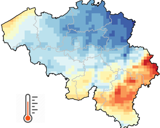
Gitterbasierte Beobachtungsdaten liefern eine Schätzung der räumlichen Verteilung einer meteorologischen Variablen auf der Grundlage von Beobachtungen. Während instrumentelle Messungen an unregelmäßig verteilten Stationen durchgeführt werden, stellen gitterbasierte Daten die meteorologische Variable auf einem vordefinierten regelmäßigen Gitter dar. Gitterbasierte Beobachtungsdaten sind von großem Nutzen in Disziplinen, die verteilte quantitative Modelle anwenden, um den Einfluss von Wetter und Klima zu untersuchen. Gitterbasierte Daten sind auch sehr praktisch, um Schätzungen für jeden spezifischen Ort zu liefern, der für den Nutzer von Interesse ist.
Gitterbasierte Beobachtungsdaten für Belgien mit einer räumlichen Auflösung von 5 km (= 1360 Pixel) sind für verschiedene Variablen (Niederschläge, Lufttemperatur, Sonnenscheindauer, Sonneneinstrahlung, relative Luftfeuchtigkeit und Windgeschwindigkeit) sowie für verschiedene zeitliche Auflösungen (tägliche, monatliche, saisonale, jährliche Werte sowie langfristige Klimadurchschnittswerte) verfügbar.
Die gerasterte Datenbank beginnt für die meisten Variablen im Jahr 1961 und wird täglich mit den verfügbaren Beobachtungen des Vortages aktualisiert. Alle Raster werden dann zur Archivierung aktualisiert, sobald die Datenqualitätskontrolle abgeschlossen ist.
Zusätzlich zu den 5 km x 5 km-Rastern sind auch räumliche Durchschnittswerte für alle belgischen Gemeinden verfügbar.
Dieses Produkt ist noch nicht öffentlich verfügbar.
Die täglichen Klimadaten im Gitterraster stehen nach der Registrierung auf unserer Open-Data-Website für akademische Profile zur Verfügung.
Simple
- Datum (Überarbeitung)
- 2025-10-08
- Identifikator
- RMI-be / griddedobs
- Bearbeitungsstatus
- Kontinuierliche Aktualisierung
- Überarbeitungsintervall
- Täglich
- GEMET - INSPIRE themes, version 1.0
-
- Meteorologisch-geografische Kennwerte
- Keywords Schlüsselwörter
-
- Reporting INSPIRE
- federal government
- observation
- interpolated observations
- climate grids
- belgian municipalities
- air temperature
- precipitation
- wind speed
- solar radiation
- sunshine duration
- relative humidity
- Spatial scope
- Zugriffseinschränkungen
- Benutzerdeifinierte Einschränkungen
- Andere Einschränkungen
- Öffentliche Zugang nicht beschränkt
- Nutzungseinschränkungen
- Benutzerdeifinierte Einschränkungen
- Sicherheitseinstufung
- Unbeschränkt
- Räumliche Darstellungsart
- Raster, Gitter
- Sprache
- English
- Thematik
-
- Atmosphäre
))
- Anfangszeitpunkt
- 1961-01-01T00:00:00
- Code
- EPSG:4258
- Abgabeformat
-
-
CSV
(
1.0
)
-
CSV
(
1.0
)
- Online
-
KMI-Portal für offene Daten
(
WWW:LINK-1.0-http--link
)
KMI-Portal für offene Daten
- Bezugsebene
- Datenbestand
- Andere
- dataset
Konsistenz des Wertebereichs
- Testverfahren
- INSPIRE Conformity
Konformitätsergebnis
- Datum (Publikation)
- 2010-12-08
- Erklärung
- See the referenced specification
- Bestanden
- Nein
- Erläuterung
- Die Klimagitter sind das Ergebnis einer räumlichen Interpolation von Beobachtungen. Die Interpolationsmethode wird an jede Variable und zeitliche Auflösung angepasst. Wenn möglich, werden bei den statistischen Verfahren zusätzlich zu den Beobachtungen auch stark korrelierte Zusatzdaten berücksichtigt. Um nur einige Beispiele zu nennen: Die Lufttemperatur wird von mehreren Faktoren beeinflusst, darunter die Höhe des Geländes und die Nähe zu Gewässern. Die Sonneneinstrahlung wird hauptsächlich von der Bewölkung bestimmt, die anhand von Meteosat-Satellitendaten charakterisiert werden kann.
- Metadatensatzidentifikator
- RMI_DATASET_GRIDDEDOBS XML
- Sprache
- English
- Hierarchieebene
- Datenbestand
- Datum
- 2025-10-08