 geo.be Metadata Catalog
Données d'observation en grille
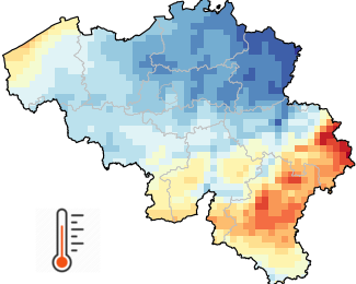
Les données d'observation maillées fournissent une estimation de la distribution spatiale d'une variable météorologique sur la base d'observations. Alors que les mesures instrumentales sont effectuées dans des stations réparties de manière irrégulière, les données maillées représentent la variable météorologique sur une grille régulière prédéfinie. Les données d'observation maillées sont très utiles dans les disciplines qui appliquent des modèles quantitatifs distribués pour examiner l'influence du temps et du climat. Les données maillées sont également très pratiques pour fournir des estimations pour tout emplacement spécifique intéressant l'utilisateur.
Des données d'observation maillées couvrant la Belgique avec une résolution spatiale de 5 km (= 1360 pixels) sont disponibles pour plusieurs variables (précipitations, température de l'air, durée d'ensoleillement, rayonnement solaire, humidité relative et vitesse du vent) ainsi que pour différentes résolutions temporelles (valeurs quotidiennes, mensuelles, saisonnières, annuelles et moyennes climatiques à long terme).
La base de données maillées commence en 1961 pour la plupart des variables et est mise à jour chaque jour avec les observations disponibles de la veille. Toutes les grilles sont ensuite mises à jour pour archivage dès que le contrôle de la qualité des données est terminé.
En plus des grilles de 5 km x 5 km, des moyennes spatiales pour chaque commune belge sont également disponibles.
Ce produit n'est pas encore accessible au public.
Les données climatiques quotidiennes maillées sont disponibles pour les profils universitaires après inscription sur notre site web de données ouvertes.
Simple
- Date (Révision)
- 2025-10-08
- Identificateur
- RMI-be / griddedobs
- Etat
- Mise à jour continue
- Fréquence de mise à jour
- Journalière
- GEMET - INSPIRE themes, version 1.0
-
- Caractéristiques géographiques météorologiques
- Mots clés
-
- Reporting INSPIRE
- federal government
- observation
- interpolated observations
- climate grids
- belgian municipalities
- air temperature
- precipitation
- wind speed
- solar radiation
- sunshine duration
- relative humidity
- Spatial scope
- Contraintes d'accès
- Autres restrictions
- Autres contraintes
- Pas de restrictions concernant l'accès public
- Contraintes d'utilisation
- Autres restrictions
- Restrictions de manipulation
- Non classifié
- Type de représentation spatiale
- Raster
- Langue
- English
- Catégorie ISO
-
- Climatologie/Météorologie/Atmosphère
))
- Date de début
- 1961-01-01T00:00:00
- Code
- EPSG:4258
- Format (encodage)
-
-
CSV
(
1.0
)
-
CSV
(
1.0
)
- Ressource en ligne
-
Portail de données ouvertes de l'IRM
(
WWW:LINK-1.0-http--link
)
Portail de données ouvertes de l'IRM
- Niveau
- Jeu de données
- Autre
- dataset
Cohérence du domaine de valeurs
- Nom du test
- INSPIRE Conformity
Résultat de conformité
- Date (Publication)
- 2010-12-08
- Explication
- See the referenced specification
- Degré de conformité
- Non
- Généralités sur la provenance
- Les grilles climatiques résultent de l'interpolation spatiale des observations. La méthode d'interpolation est adaptée à chaque variable et à chaque résolution temporelle. Lorsque cela est possible, les procédures statistiques utilisées intègrent, en plus des observations, des données auxiliaires fortement corrélées. Pour citer quelques exemples, la température de l'air est influencée par plusieurs facteurs tels que l'altitude du terrain et la proximité de surfaces aquatiques. Le rayonnement solaire est principalement déterminé par la couverture nuageuse, qui peut être caractérisée à l'aide des données du satellite Meteosat.
- Identifiant de la fiche
- RMI_DATASET_GRIDDEDOBS XML
- Langue
- English
- Type de ressource
- Jeu de données
- Date des métadonnées
- 2025-10-08