 geo.be Metadata Catalog
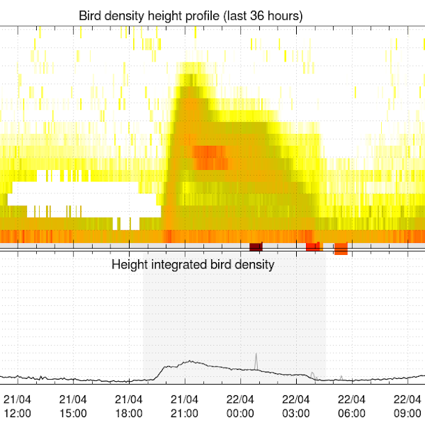
Bird density profiles derived from weather radar measurements
Bird density profiles are derived from weather radar volume data in real time, by the vol2bird algorithm as described in Dokter et al. (2011, 2019). The vol2bird algorithm exploits the radar reflectivity characteristics of different scatterers in the atmosphere, in order to distinguish biological from non-biological radar echoes. Once biological scatterers are isolated in the volume files, the reflectivity of these scatterers is converted in an estimate of the bird density per vertical layer of 200m, using a mean cross section of 11 cm2. The vbird profiles are provided for the following radars, with the radar owner in parentheses: Jabbeke (RMI), Wideumont (RMI), Helchteren (VMM), Zaventem (Skeyes), Herwijnen (KNMI), Den Helder (KNMI), Neuheilenbach (DWD), Essen (DWD), Abbeville (Météo-France) and Avesnois (Météo-France).
References:
- Dokter A.M., Liechti F., Stark H., Delobbe L., Tabary P., Holleman I., Bird migration flight altitudes studied by a network of operational weather radars, J. R. Soc. Interface, 8, 30–43, 2011, DOI 10.1098/rsif.2010.0116
- Dokter A.M., Desmet P., Spaaks J.H., van Hoey S., Veen L., Verlinden L., Nilsson C., Haase G., Leijnse H., Farnsworth A., Bouten W., Shamoun-Baranes J., bioRad: biological analysis and visualization of weather radar data, Ecography, 42, 852-860, 2019, DOI 10.1111/ecog.04028
Simple
- Date (Revision)
- 2025-10-20
- Identifier
- RMI-be / crow
- Status
- On going
- Maintenance and update frequency
- Continual
- GEMET - INSPIRE themes, version 1.0
-
- Atmospheric conditions
- Keywords
-
- federal government
- weather radar
- observation
- bird migration
- radar ornithology
- altitude profile
- Spatial scope
- Access constraints
- Other restrictions
- Other constraints
- No limitations on public access
- Use constraints
- Other restrictions
- Classification
- Unclassified
- Spatial representation type
- Vector
- Distance
- 5000 http://standards.iso.org/ittf/PubliclyAvailableStandards/ISO_19139_Schemas/resources /uom/ML_gmxUom.xml#m
- Metadata language
- English
- Topic category
-
- Climatology, meteorology, atmosphere
))
- Begin date
- 2019-10-16T00:00:00
- Unique resource identifier
- EPSG:4258
- Distribution format
-
-
txt
(
1
)
-
txt
(
1
)
- OnLine resource
-
RMI open data portal
(
WWW:LINK-1.0-http--link
)
RMI open data portal
- OnLine resource
-
HTTP directory of text data files
(
WWW:LINK-1.0-http--link
)
HTTP directory of text data files
- OnLine resource
-
FTP directory of text data files
(
WWW:DOWNLOAD-1.0-ftp--download
)
FTP directory of text data files
- Hierarchy level
- Dataset
- Other
- dataset
Domain consistency
- Name of measure
- INSPIRE Conformity
Conformance result
- Date (Publication)
- 2010-12-08
- Explanation
- See the referenced specification
- Pass
- No
- Statement
-
Bird density profiles are generated for every individual radar volume scan, and hence inherit the time resolution from the originating radar scan cycle. All radars used in this data repository operate in a five minute scan cycle.
The produced output file is a plain text file, and contains a concatenation of subsequent vertical profile outputs (vpts = vertical profile time series). It contains the following columns:
- date: Date (UTC)
- time: Time (UTC)
- HGHT: Height bin (lower bound) in m above ground level.
- u: Speed component west to east in m/s.
- v: Speed component north to south in m/s.
- w: Vertical speed (unreliable!) in m/s.
- ff: Horizontal speed in m/s.
- dd: Direction in degrees clockwise from north.
- sd_vvp: VVP radial velocity standard deviation in m/s.
- gap: Angular data gap detected in T/F.
- dbz: Animal reflectivity factor in dBZ.
- eta: Animal reflectivity in cm2/km3.
- dens: Animal density in animals/km3.
- DBZH: Total reflectivity factor (bio + meteo scattering) in dBZ.
- n: Number of data points used for the ground speed estimates (quantities u, v, w, ff, dd).
- n_all: Number of data points used for the radial velocity standard deviation estimate (quantity sd_vvp).
- n_dbz: Number of data points used for reflectivity-based estimates (quantities dbz, eta, dens).
- n_dbz_all: Number of data points used for the total reflectivity estimate (quantity DBZH).
The bird density profiles are provided as is, without any manual or automatic quality control.
- File identifier
- RMI_DATASET_CROW XML
- Metadata language
- English
- Hierarchy level
- Dataset
- Date stamp
- 2025-10-20
Overviews
Spatial extent
Provided by
