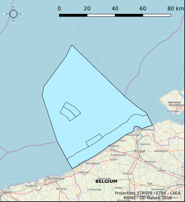
Fishery management zones in the Belgian Part of the North Sea
Simple
- Date (Creation)
- 2021-11-18
- Date (Revision)
- 2021-11-22
- Date (Publication)
- 2026-02-12
- Date (Creation)
- 2016-05-19
- Unique resource identifier
- https://doi.org/10.24417/e2aaecaf-b555-405e-ae77-dfe1b07e0f17
- Identifier
-
http://metadata.naturalsciences.be
/
e2aaecaf-b555-405e-ae77-dfe1b07e0f17
- Date
- Other citation details
- This dataset is composed of the following sources: (1) Fishery management zones in the Belgian Part of the North Sea. (2) MSP 2014-2020 Fishery management zones in the Belgian Part of the North Sea. (3) MSP 2020-2026 Fishery management zones in the Belgian Part of the North Sea. (4) SWAP (n.d.). MarineAtlas website.MarineAtlas website.
https://odnature.naturalsciences.be/
https://www.bmdc.be
- Keywords
-
- Marine Spatial Plan
- Area management/restriction/regulation zones and reporting units
- Reporting INSPIRE
- Federal government
- Use constraints
- Other restrictions
- Other constraints
- No conditions apply to access and use
- Other constraints
- https://creativecommons.org/licenses/by/4.0/
- Access constraints
- Other restrictions
- Other constraints
- No limitations on public access.
- Use limitation
- No conditions apply to use.
- Classification
- Unclassified
- Spatial representation type
- Vector
- Metadata language
- English
- Topic category
-
- Economy
- Oceans
- Planning cadastre
))
- Extent type code
- Yes
- Date
- Unique resource identifier
- North Sea
- gml32:beginPosition
- 2014-01-01
- Reference system identifier
- http://www.opengis.net/def/crs/EPSG/0/4258
- Distribution format
-
-
application/xml
(
Unknown
)
-
text/html
(
Unknown
)
-
application/xml
(
Unknown
)
Distributor
https://www.bmdc.be
- Name
- application/xml
- Version
- Unknown
- Transfer size
- 0.218439
- OnLine resource
-
imsp:bmsp_fisheries_zone
(
OGC:WMS
)
A WMS service to view a map
Distributor
https://www.bmdc.be
- Name
- application/xml
- Version
- Unknown
- Transfer size
- 0.111594
- OnLine resource
-
imsp:bmsp_fisheries_zone
(
OGC:WFS
)
A WFS service to download
Distributor
https://www.bmdc.be
- Name
- application/xml
- Version
- Unknown
- Transfer size
- 0.225898
- OnLine resource
-
imsp19:bmsp_fisheries_zone
(
OGC:WMS
)
A WMS service to view a map
Distributor
https://www.bmdc.be
- Name
- application/xml
- Version
- Unknown
- Transfer size
- 0.116278
- OnLine resource
-
imsp19:bmsp_fisheries_zone
(
OGC:WFS
)
A WFS service to download
Distributor
https://www.bmdc.be
- Name
- text/html
- Version
- Unknown
- Transfer size
- 0.008877
- OnLine resource
-
MarineAtlas website. SWAP
(
WWW:LINK-1.0-http--link
)
An HTTP link to view information
- OnLine resource
- Digital Object Identifier (DOI) ( DOI )
- Hierarchy level
- Dataset
Conformance result
- Date (Publication)
- 2010-12-08
- Explanation
- See the referenced specification
- Pass
- Yes
- Statement
- Dataset is quality assured. Dataset corresponds to a digitized version of the information published in the Belgian official gazette ("Belgisch staatsblad/Moniteur belge"). Only the information published in the official gazette has legal validity.
- File identifier
- e2aaecaf-b555-405e-ae77-dfe1b07e0f17 XML
- Metadata language
- English
- Character set
- UTF8
- Hierarchy level
- Dataset
- Date stamp
- 2026-02-12T16:29:48.650Z
- Metadata standard name
- Geographic information -- Metadata
- Metadata standard version
- ISO 19115:2003/19139
Overviews

Spatial extent
))
Provided by

 geo.be Metadata Catalog