geo.be Metadata Catalog
Urban audit-Belgium
Audit urbain - Belgique
Stedelijke audit-België
Städteaudit-Belgien
The data set includes three types of breakdown: Cities, Larger Urban zones or Functional Urban areas.
BE_StatisticsBelgium_SH_SU_UA_CITY presents in the form of polygons the borders of the Belgian cities participating to the Urban Audit of the European Commission. Some cities consist in only one municipality (LAU2) while the others are the result of the aggregation of several municipalities (LAU2). Several versions of the breakdown (2001, 2002, 2010, 2019) follow one another because over the years new cities have taken part in it. The files can be linked to the statistical data collected for the Urban Audit.
BE_StatisticsBelgium_SH_SU_UA_LUZ and BE_StatisticsBelgium_SH_SU_UA_FUA present in the form of polygons the areas of influence of the Urban Audit cities on the surrounding municipalities. The initial concept of Larger Urban Zones (LUZ) was replaced by the concept of Functional Urban areas (FUA) to take into account the movement of workers to the Urban Audit cities. LUZ / FUA are an aggregation of municipalities (LAU2). Several versions of the breakdown (2001, 2002, 2010, 2019) follow one another because over the years new LUZ / FUA have appeared or have seen their extension modified. The files can be linked to the statistical data collected for the Urban Audit.
Le jeu de données reprend trois types de découpage : Cities, Larger Urban zones ou Functional Urban areas.
BE_StatisticsBelgium_SH_SU_UA_CITY représente sous forme de polygones les limites des cities (villes) belges participant à l’Audit Urbain de la Commission européenne. Certaines villes sont composées d’une seule commune (LAU2) tandis que les autres résultent de l’agrégation de plusieurs communes (LAU2). Plusieurs versions du découpage (2001, 2002, 2010, 2019) se succèdent car au fil des années de nouvelles villes y ont pris part. Les fichiers peuvent être liés avec les données statistiques collectées pour l’Audit Urbain.
BE_StatisticsBelgium_SH_SU_UA_LUZ et BE_StatisticsBelgium_SH_SU_UA_FUA représentent sous forme de polygones les zones d’influence des cities (villes) de l’Audit Urbain sur les communes environnantes. Le concept initial de Larger Urban Zones (LUZ) a été remplacé par le concept de Functional Urban areas (FUA) pour tenir compte des déplacements des travailleurs vers les villes de l’Audit urbain. Les LUZ / FUA sont une agrégation de communes (LAU2). Plusieurs versions du découpage (2001, 2002, 2010, 2019) se succèdent car au fil des années de nouvelles LUZ / FUA sont apparues ou ont vu leur extension modifiée. Les fichiers peuvent être liés avec les données statistiques collectées pour l’Audit Urbain.
De dataset omvat drie types van ruimtelijke indeling: Cities, Larger Urban Zones of Functional Urban Areas.
In BE_StatisticsBelgium_SH_SU_UA_CITY worden in de vorm van veelhoeken de grenzen weergegeven van de Belgische steden (cities) die deelnemen aan de Urban Audit van de Europese Commissie. Bepaalde cities bestaan uit slechts één gemeente (LAU2), terwijl andere ontstaan zijn door samenvoeging van meerdere gemeenten (LAU2). Doordat in de loop der jaren weer andere steden aan de Audit hebben deelgenomen, is het bestand een opeenvolging van verschillende versies (2001, 2002, 2010, 2019) van de ruimtelijke indeling. De bestanden kunnen worden gekoppeld met de statistische gegevens die met het oog op de Urban Audit zijn verzameld.
In BE_StatisticsBelgium_SH_SU_UA_LUZ et BE_StatisticsBelgium_SH_SU_UA_FUA staan in de vorm van veelhoeken de invloedgebieden weergegeven van de Urban Audit-steden (cities) t.a.v. de omliggende gemeenten. Om de verplaatsingen van werkende mensen naar Urban Audit-steden mee in aanmerking te nemen werd het oorspronkelijke begrip Larger Urban Zones (LUZ) vervangen door het begrip Functional Urban areas (FUA). LUZ / FUA zijn samenvoegingen van gemeenten (LAU2). Doordat in de loop der jaren nieuwe LUZ / FUA zijn ontstaan of de uitbreiding van een aantal LUZ / FUA is gewijzigd, is het bestand een opeenvolging van verschillende versies (2001, 2002, 2010, 2019) van de ruimtelijke indeling. De bestanden kunnen worden gekoppeld met de statistische gegevens die met het oog op de Urban Audit zijn verzameld.
Der Datensatz umfasst drei Typen der Gebietsuntergliederung: Cities, Larger Urban Zones bzw. Functional Urban Areas.
In BE_StatisticsBelgium_SH_SU_UA_CITY werden die Grenzen der belgischen Cities (Städte), die am Urban Audit der Europäischen Kommission teilgenommen haben, als Polygone dargestellt. Einige dieser Städte sind aus einer einzigen Gemeinde zusammengesetzt (LAU2), während andere aus der Zusammenfügung mehrerer Gemeinden (LAU2) entstehen. Da im Lauf der Jahre neue Städte am Audit teilgenommen haben, kommt die Datei als eine Aufeinanderfolge unterschiedlicher Versionen (2001, 2002, 2010, 2019) der Gebietsuntergliederung vor. Die Dateien können mit den statistischen Daten, die zwecks des Urban Audits versammelt wurden, verknüpft werden.
In BE_StatisticsBelgium_SH_SU_UA_LUZ et BE_StatisticsBelgium_SH_SU_UA_FUA sind die Einflussgebiete der Cities (Städte), die am Urban Audit teilgenommen haben, gegenüber den umliegenden Gemeinden als Polygone dargestellt. Um die Fahrten von Erwerbstätigen hin zu der Stadt des Urban Audits mitzuberücksichtigen, ist der anfängliche Begriff Larger Urban Zones (LUZ) durch den Begriff Functional Urban areas (FUA) ersetzt worden. Die LUZ / FUA sind Zusammenfügungen von Gemeinden (LAU2). Da im Lauf der Jahre neue LUZ / FUA entstanden sind bzw. sich ihre Ausweitung geändert hat, kommt die Datei als eine Aufeinanderfolge unterschiedlicher Versionen (2001, 2002, 2010, 2019) der Gebietsuntergliederung vor. Die Dateien können mit den statistischen Daten, die zwecks des Urban Audits versammelt wurden, verknüpft werden.
Simple
-
Date (Création)Datum (creatie)Datum (Erstellung)Date (Creation)
- 2012-01-17T00:00:00
-
IdentificateurIdentifierIdentifikatorIdentifier
- BE.STATBEL / BE_STATBEL_SH_SU_UA
-
PurposeButDoel van vervaardigingZweck
-
The file has been made for the urban audit surveys of the European Commission.Le fichier a été créé pour l’Audit Urbain de la Commission européenne.Het bestand werd gecreëerd voor de Urban Audit surveys van de Europese Commissie.Die Datei wurde zwecks der Städteaudit-Erhebungen der Europäischen Kommission erstellt.
-
CreditReconnaissanceKredietBeteiligte
-
STATBELSTATBELSTATBELSTATBEL
-
EtatStatusBearbeitungsstatusStatus
-
FinalisécompleetAbgeschlossenCompleted
-
Fréquence de mise à jourHerzieningsfrequentieÜberarbeitungsintervallMaintenance and update frequency
-
Lorsque nécessaireindien nodigBei BedarfAs needed
-
Belgian Federal Thesaurus
-
-
Reporting INSPIREReporting INSPIREReporting INSPIREReporting INSPIRE
-
Administrative, statistical and cadastral unitsUnités administratives, statistiques et cadastralesAdministratieve, statistische en kadastrale eenhedenVerwaltungs-, statistische und Katastereinheiten
-
Federal AtomFederal AtomFederal AtomFederal Atom
-
-
Contraintes d'utilisation(Juridische) gebruiksbeperkingNutzungseinschränkungenUse constraints
-
Autres restrictionsandersBenutzerdeifinierte EinschränkungenOther restrictions
-
Other constraintsAutres contraintesOverige beperkingenAndere Einschränkungen
-
An open data license is available in French and Dutch. See https://statbel.fgov.be/en/open-dataUne licence open data est disponible en français et en néerlandais : https://statbel.fgov.be/fr/open-data.Een opendata licensie is beschrikbaa in het Frans en in het Nederlands: https://statbel.fgov.be/nl/open-data.Eine Open Data-Lizenz ist in französischer und niederländischer Sprache erhältlich. Siehe https://statbel.fgov.be/en/open-data
-
Restrictions de manipulationVeiligheidsrestrictiesSicherheitseinstufungClassification
-
Non classifiévrij toegankelijkUnbeschränktUnclassified
-
Contraintes d'accès(Juridische) toegangsrestrictieZugriffseinschränkungenAccess constraints
-
Autres restrictionsandersBenutzerdeifinierte EinschränkungenOther restrictions
-
Other constraintsAutres contraintesOverige beperkingenAndere Einschränkungen
-
No limitations on public accessPas de restrictions concernant l'accès publicGeen beperkingen op openbare toegangÖffentliche Zugang nicht beschränkt
-
Use limitationLimitation d'utilisationGebruiksbeperkingenAnwendungseinschränkungen
-
An open data license is available in French and Dutch. See https://statbel.fgov.be/en/open-dataUne licence open data est disponible en français et en néerlandais : https://statbel.fgov.be/fr/open-data.Een opendata licensie is beschrikbaa in het Frans en in het Nederlands: https://statbel.fgov.be/nl/open-data.Eine Open Data-Lizenz ist in französischer und niederländischer Sprache erhältlich. Siehe https://statbel.fgov.be/en/open-data
-
Type de représentation spatialeRuimtelijk schemaRäumliche DarstellungsartSpatial representation type
-
VecteurvectorVektorVector
-
Dénominateur de l'échelleToepassingsschaalMassstabszahlDenominator
- 10000
-
LangueTaalSpracheMetadata language
- English
-
Jeu de caractèresKaraktersetZeichensatzCharacter set
-
Utf8utf8Utf8UTF8
-
Catégorie ISOOnderwerpThematikTopic category
-
-
LimitesgrenzenGrenzenBoundaries
-
))
- gml32:beginPosition
- 2010-01-01
-
Unique resource identifier
-
EPSG:3035
-
Format (encodage)Distributie formaatAbgabeformatDistribution format
-
-
GMLGMLGMLGML( 3.2.1 )
-
Esri Shapefile( )
-
GeoPackage( )
-
-
Ressource en ligneOnLine bronnenOnlineOnLine resource
-
Downloadable data Données téléchargeables Downloadable data Downloadable Data
(
WWW:DOWNLOAD-1.0-http--download
)
Downloadable dataDonnées téléchargeablesDownloadable dataDownloadable Data
-
Ressource en ligneOnLine bronnenOnlineOnLine resource
-
Downloadable data Données téléchargeables Downloadable data Downloadable Data
(
WWW:DOWNLOAD-1.0-http--download
)
Downloadable dataDonnées téléchargeablesDownloadable dataDownloadable Data
-
Ressource en ligneOnLine bronnenOnlineOnLine resource
-
Downloadable data Données téléchargeables Downloadable data Downloadable Data
(
WWW:DOWNLOAD-1.0-http--download
)
Downloadable dataDonnées téléchargeablesDownloadable dataDownloadable Data
-
Ressource en ligneOnLine bronnenOnlineOnLine resource
-
http://ec.europa.eu/eurostat/web/cities/spatial-units https://ec.europa.eu/eurostat/fr/web/cities/spatial-units http://ec.europa.eu/eurostat/web/cities/spatial-units https://ec.europa.eu/eurostat/de/web/cities/spatial-units
(
WWW:LINK-1.0-http--link
)
Link to the urban Audit Site of the European CommissionLien vers le site de l’Audit urbain de la Commission européenneLink naar de stedelijke Audit site van de Europese CommissieLink zur Städteaudit-Webseite der Europäischen Kommission
-
Ressource en ligneOnLine bronnenOnlineOnLine resource
-
View service Service de visualisation Raadpleegdienst Darstellungsdienste
(
OGC:WMS
)
View serviceService de visualisationRaadpleegdienstDarstellungsdienste
-
Ressource en ligneOnLine bronnenOnlineOnLine resource
- https://ac.ngi.be/remoteclient-open/GeoBePartners-open/ATOM/d68c5d6b-13df-4fe1-8b4a-4a7a8219ea45-en.xml https://ac.ngi.be/remoteclient-open/GeoBePartners-open/ATOM/d68c5d6b-13df-4fe1-8b4a-4a7a8219ea45-fr.xml https://ac.ngi.be/remoteclient-open/GeoBePartners-open/ATOM/d68c5d6b-13df-4fe1-8b4a-4a7a8219ea45-nl.xml https://ac.ngi.be/remoteclient-open/GeoBePartners-open/ATOM/d68c5d6b-13df-4fe1-8b4a-4a7a8219ea45-de.xml ( ATOM )
-
Ressource en ligneOnLine bronnenOnlineOnLine resource
-
Urban audit perimeters périmètres de l'audit urbain Urban audit perimeters Städteaudit-Perimeter
(
WWW:LINK-1.0-http--link
)
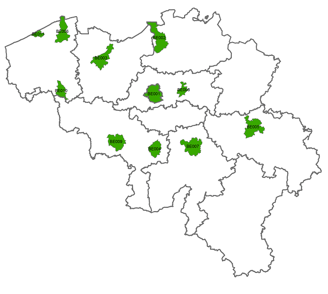
Map of the urban audit perimeters, BelgiumCarte des périmètres de l’Audit urbain, BelgiqueKaart met de Urban Audit afbakeningen, BelgiëKarte der Städteaudit-Perimeter, Belgien
-
NiveauNiveau kwaliteitsbeschrijvingBezugsebeneHierarchy level
-
Jeu de donnéesdatasetDatenbestandDataset
Cohérence du domaine de valeurs
Domain consistentie
Konsistenz des Wertebereichs
Domain consistency
-
Name of measureNom du testName of measureTestverfahren
-
INSPIRE ConformityConformité INSPIREINSPIRE ConformiteitINSPIRE Konformität
Résultat de conformité
Resultaat conformiteit met de specificatie
Konformitätsergebnis
Conformance result
-
Date (Publication)Datum (publicatie)Datum (Publikation)Date (Publication)
- 2010-12-08
-
ExplanationExplicationUitlegErklärung
-
The dataset described fills the technical requirements sustaining the interoperability of data sets and services, as stipulated in the Commission Regulation (EU) No 1089/2010 of 23 November 2010Le jeu de données décrit répond aux exigences techniques assurant l’interopérabilité des jeux de données et des services, telles qu’elles sont définies par le Règlement (UE) n° 1089/2010 de la Commission du 23 novembre 2010.De beschreven dataset beantwoordt aan de technische vereisten die de interoperabiliteit van verzamelingen gegevens et van diensten verzekeren, zoals bepaald in de Verordening (EU) Nr. 1089/2010 van de Commissie van 23 november 2010Der beschriebene Datensatz erfüllt die technischen Anforderungen, die die Interoperabilität der Datensätze und Dienste versichern, wie festgelegt in der Verordnung (EG) Nr. 1089/2010 der Kommission vom 23. November 2010
-
Degré de conformitéIndicatie van conformiteit met de specificatieBestandenPass
- Yes
-
StatementGénéralités sur la provenanceAlgemene beschrijving herkomstErläuterung
-
The files were obtained based on the aggregation of statistical sectors included in the statistical sector file BE_STATBEL_SH_SU_STATDISCes fichiers ont été obtenus à partir de l’agrégation de secteurs statistiques repris dans le fichier des secteurs statistiques BE_STATBEL_SH_SU_STATDISDie bestanden zijn ontstaan uit de samenvoeging van de statistische sectoren opgenomen in het bestand van de statistische sectoren BE_STATBEL_SH_SU_STATDISDiese Dateien sind zustande gekommen durch Zusammenfügen von statistischen Sektoren aus der Datei der statistischen Sektoren BE_STATBEL_SH_SU_STATDIS
-
Identifiant de la ficheMetadata IDMetadatensatzidentifikatorFile identifier
- d68c5d6b-13df-4fe1-8b4a-4a7a8219ea45 XML
-
LangueTaalSpracheMetadata language
- English
-
Jeu de caractèresKaraktersetZeichensatzCharacter set
-
Utf8utf8Utf8UTF8
-
Type de ressourceHierarchisch niveauHierarchieebeneHierarchy level
-
Jeu de donnéesdatasetDatenbestandDataset
-
Date des métadonnéesMetadata datumDatumDate stamp
- 2024-11-12T10:48:46
-
Metadata standard name
-
ISO 19115:2003/19139
- Metadata standard version
- 1.0
Overviews
Spatial extent
Provided by