 geo.be Metadata Catalog
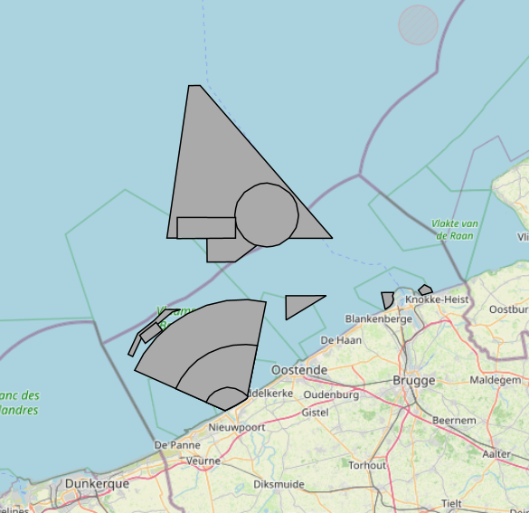
2026 Belgian MSP - Military use zones
The Royal Decree of 20 March 2026 establishing the marine spatial plan for the period 2026 to 2034 in the Belgian marine areas defines 13 military use zones: Mine warfare exercise zone – QZR 040 (Art. 21§1.1°), Mine warfare exercise zone – NBH-10 (Wenduine) (Art. 21§1.2°), Mine warfare exercise zone – NB-01 (Westhinder) (Art. 21§1.3°), Mine warfare exercise zone (Buiten Ratel) (Art. 21§1.4°), Belgisch Nationaal Oefengebied voor Marineschepen (BNOM) (Art. 21§1.5°), Shallow Water Zone (Art. 21§1.6°), Zone for detonation exercises and operations (Art. 21§2), Lombardsijde firing sector: small sector (Art. 21§3.1°), Lombardsijde firing sector: middle sector (Art. 21§3.2°), Lombardsijde firing sector: large sector (Art. 21§3.3°), Paardenmarkt munitions disposal site (Art. 22§1). It replaces the 2020 Marine Spatial Plan. Please refer to the Belgian official gazette ("Moniteur belgeBelgisch Staatsblad") for official reference information.
Simple
- Date (Creation)
- 2026-06-08
- Date (Revision)
- 2026-06-18
- Date (Publication)
- 2026-07-14
- Date (Creation)
- 2016-05-19
- Unique resource identifier
- https://doi.org/10.24417/bmdc.be:dataset:3125
- Identifier
-
http://metadata.naturalsciences.be
/
bmdc.be:dataset:3125
- Date
- Other citation details
- This dataset is composed of the following sources: MSP 2026-2032 Military use and storage sites for war munition zones.
Custodian
Royal Belgian Institute of Natural Sciences (RBINS), Directorate Natural Environment (OD Nature), Belgian Marine Data Centre (BMDC)
https://www.bmdc.be
https://www.bmdc.be
- Theme
-
- Marine Spatial Plan
- military activities
- Reporting INSPIRE
- Area management/restriction/regulation zones and reporting units
- Federal government
- Use constraints
- Other restrictions
- Other constraints
- No conditions apply to access and use
- Other constraints
- https://creativecommons.org/licenses/by/4.0/
- Access constraints
- Other restrictions
- Other constraints
- No limitations on public access.
- Use limitation
- No conditions apply to use.
- Classification
- Unclassified
- Spatial representation type
- Vector
- Metadata language
- English
- Topic category
-
- Intelligence military
- Oceans
- Planning cadastre
N
S
E
W
))
- gml32:beginPosition
- 2026-03-20
- Reference system identifier
- http://www.opengis.net/def/crs/EPSG/0/4258
- Distribution format
-
-
application/xml
(
Unknown
)
-
application/xml
(
Unknown
)
Distributor
Custodian
Royal Belgian Institute of Natural Sciences (RBINS), Directorate Natural Environment (OD Nature), Belgian Marine Data Centre (BMDC)
https://www.bmdc.be
https://www.bmdc.be
- Name
- application/xml
- Version
- Unknown
- Transfer size
- 0.247716
- OnLine resource
-
imsp26:bmsp_military_zone
(
OGC:WMS
)
A WMS service to view a map
Distributor
Custodian
Royal Belgian Institute of Natural Sciences (RBINS), Directorate Natural Environment (OD Nature), Belgian Marine Data Centre (BMDC)
https://www.bmdc.be
https://www.bmdc.be
- Name
- application/xml
- Version
- Unknown
- Transfer size
- 0.113308
- OnLine resource
-
imsp26:bmsp_military_zone
(
OGC:WFS
)
A WFS service to download
- OnLine resource
- Digital Object Identifier (DOI) ( DOI )
- Hierarchy level
- Dataset
Conformance result
- Date (Publication)
- 2010-12-08
- Explanation
- See the referenced specification
- Pass
- Yes
- Statement
- Dataset is quality assured. Dataset corresponds to a digitized version of the information published in the Belgian official gazette ("Belgisch staatsblad/Moniteur belge"). Only the information published in the official gazette has legal validity.
- File identifier
- bmdc.be:dataset:3125 XML
- Metadata language
- English
- Character set
- UTF8
- Hierarchy level
- Dataset
- Date stamp
- 2026-07-14T15:33:05.010Z
- Metadata standard name
- Geographic information -- Metadata
- Metadata standard version
- ISO 19115:2003/19139
Overviews
large_thumbnail
Spatial extent
N
S
E
W
Provided by

Associated resources
Not available