 geo.be Metadata Catalog
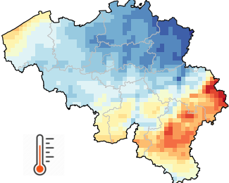
Rastervormige observatiegegevens
Rasterobservatiegegevens bieden een schatting van de ruimtelijke verdeling van een meteorologische variabele op basis van observaties. Terwijl instrumentele metingen worden uitgevoerd op onregelmatig verdeelde stations, geven rastergegevens de meteorologische variabele weer op een vooraf gedefinieerd regelmatig raster. Rasterobservatiegegevens zijn zeer nuttig in disciplines die gedistribueerde kwantitatieve modellen toepassen om de invloed van het weer en het klimaat te onderzoeken. Rastergegevens zijn ook erg handig om schattingen te geven voor elke specifieke locatie die voor de gebruiker van belang is.
Rasterobservatiegegevens voor België met een ruimtelijke resolutie van 5 km (= 1360 pixels) zijn beschikbaar voor verschillende variabelen (neerslag, luchttemperatuur, zonneschijnduur, zonnestraling, relatieve vochtigheid en windsnelheid) en verschillende temporele resoluties (dagelijkse, maandelijkse, seizoensgebonden en jaarlijkse waarden, alsook langetermijngemiddelden voor het klimaat).
De gerasterde database begint voor de meeste variabelen in 1961 en wordt elke dag bijgewerkt met de beschikbare waarnemingen van de vorige dag. Alle rasters worden vervolgens bijgewerkt voor archivering zodra de gegevenskwaliteitscontrole is voltooid.
Naast de rasters van 5 km x 5 km zijn ook ruimtelijke gemiddelden voor alle Belgische gemeenten beschikbaar.
Dit product is nog niet openbaar beschikbaar.
De dagelijkse klimaatgegevens op rasterbasis zijn beschikbaar voor academische profielen na registratie op onze open data-website.
Standaard
- Datum (revisie)
- 2025-10-08
- Identifier
- RMI-be / griddedobs
- Status
- continu geactualiseerd
- Herzieningsfrequentie
- dagelijks
- GEMET - INSPIRE themes, version 1.0
-
- Meteorologische geografische kenmerken
- Trefwoorden
-
- Reporting INSPIRE
- federal government
- observation
- interpolated observations
- climate grids
- belgian municipalities
- air temperature
- precipitation
- wind speed
- solar radiation
- sunshine duration
- relative humidity
- Spatial scope
- (Juridische) toegangsrestrictie
- anders
- Overige beperkingen
- Geen beperkingen op openbare toegang
- (Juridische) gebruiksbeperking
- anders
- Veiligheidsrestricties
- vrij toegankelijk
- Ruimtelijk schema
- grid
- Taal
- English
- Onderwerp
-
- klimatologie, meteorologie atmosfeer
))
- Begindatum
- 1961-01-01T00:00:00
- Code
- EPSG:4258
- Distributie formaat
-
-
CSV
(
1.0
)
-
CSV
(
1.0
)
- OnLine bronnen
-
KMI open data portaal
(
WWW:LINK-1.0-http--link
)
KMI open data portaal
- Niveau kwaliteitsbeschrijving
- dataset
- Anders
- dataset
Domain consistentie
- Name of measure
- INSPIRE Conformity
Resultaat conformiteit met de specificatie
- Datum (publicatie)
- 2010-12-08
- Uitleg
- See the referenced specification
- Indicatie van conformiteit met de specificatie
- Nee
- Algemene beschrijving herkomst
- De klimaatroosters zijn het resultaat van de ruimtelijke interpolatie van waarnemingen. De interpolatiemethode wordt aangepast aan elke variabele en temporele resolutie. Waar mogelijk integreren de betrokken statistische procedures naast de waarnemingen ook sterk gecorreleerde aanvullende gegevens. Om enkele voorbeelden te noemen: de luchttemperatuur wordt beïnvloed door verschillende factoren, zoals de hoogte van het terrein en de nabijheid van wateroppervlakken. Zonnestraling wordt voornamelijk bepaald door bewolking, die kan worden gekarakteriseerd aan de hand van Meteosat-satellietgegevens.
- Metadata ID
- RMI_DATASET_GRIDDEDOBS XML
- Taal
- English
- Hierarchisch niveau
- dataset
- Metadata datum
- 2025-10-08