 geo.be Metadata Catalog
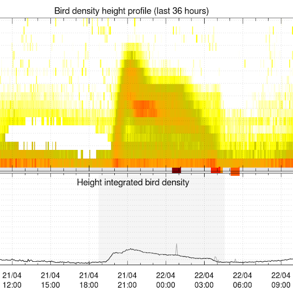
Vogeldichtheidsprofielen afgeleid van weerradarmetingen
Vogeldichtheidsprofielen worden in realtime afgeleid uit volumegegevens van weerradars, met behulp van het vol2bird-algoritme zoals beschreven in Dokter et al. (2011, 2019). Het vol2bird-algoritme maakt gebruik van de radarreflectiviteitskenmerken van verschillende verstrooiers in de atmosfeer om biologische van niet-biologische radarecho's te onderscheiden. Zodra biologische verstrooiers in de volumebestanden zijn geïsoleerd, wordt de reflectiviteit van deze verstrooiers omgezet in een schatting van de vogelconcentratie per verticale laag van 200 m, waarbij een gemiddelde doorsnede van 11 cm2 wordt gebruikt. De vbird-profielen worden verstrekt voor de volgende radars, met tussen haakjes de eigenaar van de radar: Jabbeke (KMI), Wideumont (KMI), Helchteren (VMM), Zaventem (Skeyes), Herwijnen (KNMI), Den Helder (KNMI), Neuheilenbach (DWD), Essen (DWD), Abbeville (Météo-France) en Avesnois (Météo-France).
Referenties:
- Dokter A.M., Liechti F., Stark H., Delobbe L., Tabary P., Holleman I., Bird migration flight altitudes studied by a network of operational weather radars, J. R. Soc. Interface, 8, 30–43, 2011, DOI 10.1098/rsif.2010.0116
- Dokter A.M., Desmet P., Spaaks J.H., van Hoey S., Veen L., Verlinden L., Nilsson C., Haase G., Leijnse H., Farnsworth A., Bouten W., Shamoun-Baranes J., bioRad: biological analysis and visualization of weather radar data, Ecography, 42, 852-860, 2019, DOI 10.1111/ecog.04028
Standaard
- Datum (revisie)
- 2025-10-20
- Identifier
- RMI-be / crow
- Status
- continu geactualiseerd
- Herzieningsfrequentie
- continu
- GEMET - INSPIRE themes, version 1.0
-
- Atmosferische omstandigheden
- Trefwoorden
-
- federal government
- weather radar
- observation
- bird migration
- radar ornithology
- altitude profile
- Spatial scope
- (Juridische) toegangsrestrictie
- anders
- Overige beperkingen
- Geen beperkingen op openbare toegang
- (Juridische) gebruiksbeperking
- anders
- Veiligheidsrestricties
- vrij toegankelijk
- Ruimtelijk schema
- vector
- Afstand
- 5000 http://standards.iso.org/ittf/PubliclyAvailableStandards/ISO_19139_Schemas/resources /uom/ML_gmxUom.xml#m
- Taal
- English
- Onderwerp
-
- klimatologie, meteorologie atmosfeer
))
- Begindatum
- 2019-10-16T00:00:00
- Code
- EPSG:4258
- Distributie formaat
-
-
txt
(
1
)
-
txt
(
1
)
- OnLine bronnen
-
KMI open data portaal
(
WWW:LINK-1.0-http--link
)
KMI open data portaal
- OnLine bronnen
-
HTTP-directory van tekstbestanden met gegevens
(
WWW:LINK-1.0-http--link
)
HTTP-directory van tekstbestanden met gegevens
- OnLine bronnen
-
FTP-directory van tekstbestanden met gegevens
(
WWW:DOWNLOAD-1.0-ftp--download
)
FTP-directory van tekstbestanden met gegevens
- Niveau kwaliteitsbeschrijving
- dataset
- Anders
- dataset
Domain consistentie
- Name of measure
- INSPIRE Conformity
Resultaat conformiteit met de specificatie
- Datum (publicatie)
- 2010-12-08
- Uitleg
- See the referenced specification
- Indicatie van conformiteit met de specificatie
- Nee
- Algemene beschrijving herkomst
-
Voor elke afzonderlijke radarscanscan worden vogelconcentratieprofielen gegenereerd, die dus dezelfde tijdresolutie hebben als de oorspronkelijke radarscancyclus. Alle radars die in deze gegevensopslagplaats worden gebruikt, werken met een scancyclus van vijf minuten.
Het gegenereerde uitvoerbestand is een tekstbestand en bevat een aaneenschakeling van opeenvolgende verticale profieluitvoer (vpts = verticale profieltijdreeksen). Het bevat de volgende kolommen:
- datum: datum (UTC)
- tijd: tijd (UTC)
- HGHT: Hoogteklasse (ondergrens) in m boven het maaiveld.
- u: Snelheidscomponent west naar oost in m/s.
- v: Snelheidscomponent noord naar zuid in m/s.
- w: Verticale snelheid (onbetrouwbaar!) in m/s.
- ff: Horizontale snelheid in m/s.
- dd: Richting in graden met de klok mee vanaf het noorden.
- sd_vvp: VVP radiale snelheidsstandaardafwijking in m/s.
- gap: Hoekgegevensgat gedetecteerd in T/F.
- dbz: Dierreflectiviteitsfactor in dBZ.
- eta: Dierreflectiviteit in cm2/km3.
- dens: Dierdichtheid in dieren/km3.
- DBZH: Totale reflectiviteitsfactor (bio + meteo verstrooiing) in dBZ.
- n: Aantal gegevenspunten gebruikt voor de schattingen van de grondsnelheid (grootheden u, v, w, ff, dd).
- n_all: Aantal gegevenspunten gebruikt voor de schatting van de standaardafwijking van de radiale snelheid (grootheid sd_vvp).
- n_dbz: aantal gegevenspunten dat wordt gebruikt voor op reflectiviteit gebaseerde schattingen (grootheden dbz, eta, dens).
- n_dbz_all: aantal gegevenspunten dat wordt gebruikt voor de totale reflectiviteitsschatting (grootheid DBZH).
De vogel dichtheidsprofielen worden geleverd zoals ze zijn, zonder enige handmatige of automatische kwaliteitscontrole.