 geo.be Metadata Catalog
Vogeldichtheidsprofielen afgeleid van weerradarmetingen
Profils de densité des oiseaux dérivés des mesures des radars météorologiques
Aus Wetterradarmessungen abgeleitete Vogel-Dichteprofile
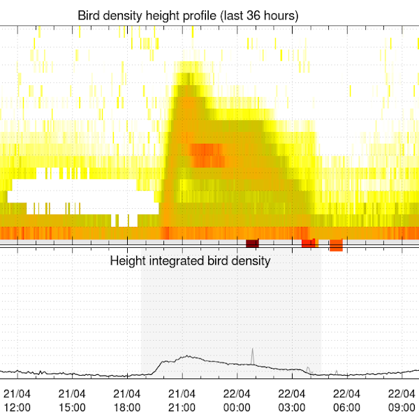
Vogeldichtheidsprofielen worden in realtime afgeleid uit volumegegevens van weerradars, met behulp van het vol2bird-algoritme zoals beschreven in Dokter et al. (2011, 2019). Het vol2bird-algoritme maakt gebruik van de radarreflectiviteitskenmerken van verschillende verstrooiers in de atmosfeer om biologische van niet-biologische radarecho's te onderscheiden. Zodra biologische verstrooiers in de volumebestanden zijn geïsoleerd, wordt de reflectiviteit van deze verstrooiers omgezet in een schatting van de vogelconcentratie per verticale laag van 200 m, waarbij een gemiddelde doorsnede van 11 cm2 wordt gebruikt. De vbird-profielen worden verstrekt voor de volgende radars, met tussen haakjes de eigenaar van de radar: Jabbeke (KMI), Wideumont (KMI), Helchteren (VMM), Zaventem (Skeyes), Herwijnen (KNMI), Den Helder (KNMI), Neuheilenbach (DWD), Essen (DWD), Abbeville (Météo-France) en Avesnois (Météo-France).
Referenties:
- Dokter A.M., Liechti F., Stark H., Delobbe L., Tabary P., Holleman I., Bird migration flight altitudes studied by a network of operational weather radars, J. R. Soc. Interface, 8, 30–43, 2011, DOI 10.1098/rsif.2010.0116
- Dokter A.M., Desmet P., Spaaks J.H., van Hoey S., Veen L., Verlinden L., Nilsson C., Haase G., Leijnse H., Farnsworth A., Bouten W., Shamoun-Baranes J., bioRad: biological analysis and visualization of weather radar data, Ecography, 42, 852-860, 2019, DOI 10.1111/ecog.04028
Les profils de densité des oiseaux sont dérivés des données volumétriques des radars météorologiques en temps réel, à l'aide de l'algorithme vol2bird décrit dans Dokter et al. (2011, 2019). L'algorithme vol2bird exploite les caractéristiques de réflectivité radar de différents diffuseurs dans l'atmosphère afin de distinguer les échos radar biologiques des échos non biologiques. Une fois les diffuseurs biologiques isolés dans les fichiers volumétriques, la réflectivité de ces diffuseurs est convertie en une estimation de la densité d'oiseaux par couche verticale de 200 m, en utilisant une section transversale moyenne de 11 cm2. Les profils vbird sont fournis pour les radars suivants, avec le nom du propriétaire du radar entre parenthèses : Jabbeke (IRM), Wideumont (IRM), Helchteren (VMM), Zaventem (Skeyes), Herwijnen (KNMI), Den Helder (KNMI), Neuheilenbach (DWD), Essen (DWD), Abbeville (Météo-France) et Avesnois (Météo-France).
Références :
- Dokter A.M., Liechti F., Stark H., Delobbe L., Tabary P., Holleman I., Bird migration flight altitudes studied by a network of operational weather radars, J. R. Soc. Interface, 8, 30–43, 2011, DOI 10.1098/rsif.2010.0116
- Dokter A.M., Desmet P., Spaaks J.H., van Hoey S., Veen L., Verlinden L., Nilsson C., Haase G., Leijnse H., Farnsworth A., Bouten W., Shamoun-Baranes J., bioRad: biological analysis and visualization of weather radar data, Ecography, 42, 852-860, 2019, DOI 10.1111/ecog.04028
Die Vogel-Dichteprofile werden in Echtzeit aus Wetterradar-Volumendaten mithilfe des vol2bird-Algorithmus abgeleitet, wie in Dokter et al. (2011, 2019) beschrieben. Der vol2bird-Algorithmus nutzt die Radarreflexionscharakteristika verschiedener Streuer in der Atmosphäre, um biologische von nicht-biologischen Radarechos zu unterscheiden. Sobald die biologischen Streuer in den Volumendateien isoliert sind, wird die Reflektivität dieser Streuer unter Verwendung eines mittleren Querschnitts von 11 cm2 in eine Schätzung der Vogel-Dichte pro vertikaler Schicht von 200 m umgewandelt. Die vbird-Profile werden für die folgenden Radargeräte bereitgestellt, wobei der Radarbetreiber in Klammern angegeben ist: Jabbeke (KMI), Wideumont (KMI), Helchteren (VMM), Zaventem (Skeyes), Herwijnen (KNMI), Den Helder (KNMI), Neuheilenbach (DWD), Essen (DWD), Abbeville (Météo-France) und Avesnois (Météo-France).
Referenzen:
- Dokter A.M., Liechti F., Stark H., Delobbe L., Tabary P., Holleman I., Bird migration flight altitudes studied by a network of operational weather radars, J. R. Soc. Interface, 8, 30–43, 2011, DOI 10.1098/rsif.2010.0116
- Dokter A.M., Desmet P., Spaaks J.H., van Hoey S., Veen L., Verlinden L., Nilsson C., Haase G., Leijnse H., Farnsworth A., Bouten W., Shamoun-Baranes J., bioRad: biological analysis and visualization of weather radar data, Ecography, 42, 852-860, 2019, DOI 10.1111/ecog.04028
Simple
-
Date (Révision)Datum (revisie)Datum (Überarbeitung)
- 2025-10-20
-
IdentificateurIdentifierIdentifikator
- RMI-be / crow
-
EtatStatusBearbeitungsstatus
-
Mise à jour continuecontinu geactualiseerdKontinuierliche Aktualisierung
-
Fréquence de mise à jourHerzieningsfrequentieÜberarbeitungsintervall
-
ContinuecontinuKontinuierlich
- GEMET - INSPIRE themes, version 1.0
-
-
Atmosferische omstandighedenConditions atmosphériquesAtmosphärische Bedingungen
-
- Keywords
-
- federal government
- weather radar
- observation
- bird migration
- radar ornithology
- altitude profile
- Spatial scope
-
Contraintes d'accès(Juridische) toegangsrestrictieZugriffseinschränkungen
-
Autres restrictionsandersBenutzerdeifinierte Einschränkungen
-
Overige beperkingenAutres contraintesAndere Einschränkungen
-
Geen beperkingen op openbare toegangPas de restrictions concernant l'accès publicÖffentliche Zugang nicht beschränkt
-
Contraintes d'utilisation(Juridische) gebruiksbeperkingNutzungseinschränkungen
-
Autres restrictionsandersBenutzerdeifinierte Einschränkungen
-
Restrictions de manipulationVeiligheidsrestrictiesSicherheitseinstufung
-
Non classifiévrij toegankelijkUnbeschränkt
-
Type de représentation spatialeRuimtelijk schemaRäumliche Darstellungsart
-
VecteurvectorVektor
-
Distance de résolutionAfstandDistanz
- 5000 http://standards.iso.org/ittf/PubliclyAvailableStandards/ISO_19139_Schemas/resources /uom/ML_gmxUom.xml#m
-
LangueTaalSprache
- English
-
Catégorie ISOOnderwerpThematik
-
-
Climatologie/Météorologie/Atmosphèreklimatologie, meteorologie atmosfeerAtmosphäre
-
))
- Begin date
- 2019-10-16T00:00:00
- Unique resource identifier
- EPSG:4258
-
Format (encodage)Distributie formaatAbgabeformat
-
-
txt
(
1
)
-
txt
(
1
)
-
Ressource en ligneOnLine bronnenOnline
-
KMI open data portaal Portail de données ouvertes de l'IRM KMI-Portal für offene Daten
(
WWW:LINK-1.0-http--link
)
KMI open data portaalPortail de données ouvertes de l'IRMKMI-Portal für offene Daten
-
Ressource en ligneOnLine bronnenOnline
-
HTTP-directory van tekstbestanden met gegevens Répertoire HTTP des fichiers textes de données HTTP-Verzeichnis der Textdateien mit Daten
(
WWW:LINK-1.0-http--link
)
HTTP-directory van tekstbestanden met gegevensRépertoire HTTP des fichiers textes de donnéesHTTP-Verzeichnis der Textdateien mit Daten
-
Ressource en ligneOnLine bronnenOnline
-
FTP-directory van tekstbestanden met gegevens Répertoire FTP des fichiers textes de données FTP-Verzeichnis der Textdateien mit Daten
(
WWW:DOWNLOAD-1.0-ftp--download
)
FTP-directory van tekstbestanden met gegevensRépertoire FTP des fichiers textes de donnéesFTP-Verzeichnis der Textdateien mit Daten
-
NiveauNiveau kwaliteitsbeschrijvingBezugsebene
-
Jeu de donnéesdatasetDatenbestand
- Other
- dataset
Cohérence du domaine de valeurs
Domain consistentie
Konsistenz des Wertebereichs
- Name of measure
- INSPIRE Conformity
Résultat de conformité
Resultaat conformiteit met de specificatie
Konformitätsergebnis
-
Date (Publication)Datum (publicatie)Datum (Publikation)
- 2010-12-08
- Explanation
- See the referenced specification
-
Degré de conformitéIndicatie van conformiteit met de specificatieBestanden
- No
-
Algemene beschrijving herkomstGénéralités sur la provenanceErläuterung
-
Voor elke afzonderlijke radarscanscan worden vogelconcentratieprofielen gegenereerd, die dus dezelfde tijdresolutie hebben als de oorspronkelijke radarscancyclus. Alle radars die in deze gegevensopslagplaats worden gebruikt, werken met een scancyclus van vijf minuten.
Het gegenereerde uitvoerbestand is een tekstbestand en bevat een aaneenschakeling van opeenvolgende verticale profieluitvoer (vpts = verticale profieltijdreeksen). Het bevat de volgende kolommen:
- datum: datum (UTC)
- tijd: tijd (UTC)
- HGHT: Hoogteklasse (ondergrens) in m boven het maaiveld.
- u: Snelheidscomponent west naar oost in m/s.
- v: Snelheidscomponent noord naar zuid in m/s.
- w: Verticale snelheid (onbetrouwbaar!) in m/s.
- ff: Horizontale snelheid in m/s.
- dd: Richting in graden met de klok mee vanaf het noorden.
- sd_vvp: VVP radiale snelheidsstandaardafwijking in m/s.
- gap: Hoekgegevensgat gedetecteerd in T/F.
- dbz: Dierreflectiviteitsfactor in dBZ.
- eta: Dierreflectiviteit in cm2/km3.
- dens: Dierdichtheid in dieren/km3.
- DBZH: Totale reflectiviteitsfactor (bio + meteo verstrooiing) in dBZ.
- n: Aantal gegevenspunten gebruikt voor de schattingen van de grondsnelheid (grootheden u, v, w, ff, dd).
- n_all: Aantal gegevenspunten gebruikt voor de schatting van de standaardafwijking van de radiale snelheid (grootheid sd_vvp).
- n_dbz: aantal gegevenspunten dat wordt gebruikt voor op reflectiviteit gebaseerde schattingen (grootheden dbz, eta, dens).
- n_dbz_all: aantal gegevenspunten dat wordt gebruikt voor de totale reflectiviteitsschatting (grootheid DBZH).
De vogel dichtheidsprofielen worden geleverd zoals ze zijn, zonder enige handmatige of automatische kwaliteitscontrole.
Les profils de densité des oiseaux sont générés pour chaque balayage radar individuel et héritent donc de la résolution temporelle du cycle de balayage radar d'origine. Tous les radars utilisés dans ce référentiel de données fonctionnent selon un cycle de balayage de cinq minutes.
Le fichier de sortie produit est un fichier texte brut qui contient une concaténation des sorties de profils verticaux successifs (vpts = séries chronologiques de profils verticaux). Il contient les colonnes suivantes :
- date : date (UTC)
- heure : heure (UTC)
- HGHT : hauteur (limite inférieure) en m au-dessus du niveau du sol.
- u : composante de vitesse ouest-est en m/s.
- v : composante de vitesse nord-sud en m/s.
- w : vitesse verticale (peu fiable !) en m/s.
- ff : vitesse horizontale en m/s.
- dd : direction en degrés dans le sens des aiguilles d'une montre à partir du nord.
- sd_vvp : écart type de la vitesse radiale VVP en m/s.
- gap : écart angulaire détecté dans les données T/F.
- dbz : facteur de réflectivité animale en dBZ.
- eta : réflectivité animale en cm2/km3.
- dens : densité animale en animaux/km3.
- DBZH : facteur de réflectivité totale (diffusion biologique + météorologique) en dBZ.
- n : nombre de points de données utilisés pour les estimations de la vitesse au sol (quantités u, v, w, ff, dd).
- n_all : nombre de points de données utilisés pour l'estimation de l'écart type de la vitesse radiale (quantité sd_vvp).
- n_dbz : nombre de points de données utilisés pour les estimations basées sur la réflectivité (quantités dbz, eta, dens).
- n_dbz_all : nombre de points de données utilisés pour l'estimation de la réflectivité totale (quantité DBZH).
Les profils de densité des oiseaux sont fournis tels quels, sans aucun contrôle qualité manuel ou automatique.
Für jeden einzelnen Radarscan werden Vogel-Dichteprofile erstellt, die somit die Zeitauflösung des ursprünglichen Radarscanzyklus übernehmen. Alle in diesem Datenarchiv verwendeten Radargeräte arbeiten mit einem Scanzyklus von fünf Minuten.
Die erstellte Ausgabedatei ist eine reine Textdatei und enthält eine Verkettung aufeinanderfolgender vertikaler Profilausgaben (vpts = vertikale Profilzeitreihen). Sie enthält die folgenden Spalten:
- date: Datum (UTC)
- time: Uhrzeit (UTC)
- HGHT: Höhenbereich (untere Grenze) in m über dem Boden.
- u: Geschwindigkeitskomponente von West nach Ost in m/s.
- v: Geschwindigkeitskomponente von Nord nach Süd in m/s.
- w: Vertikale Geschwindigkeit (unzuverlässig!) in m/s.
- ff: Horizontale Geschwindigkeit in m/s.
- dd: Richtung in Grad im Uhrzeigersinn von Norden aus.
- sd_vvp: Standardabweichung der VVP-Radialgeschwindigkeit in m/s.
- gap: In T/F erkannte Winkel-Datenlücke.
- dbz: Tierreflexionsfaktor in dBZ.
- eta: Tierreflexion in cm2/km3.
- dens: Tierdichte in Tieren/km3.
- DBZH: Gesamtreflektivitätsfaktor (Bio- + Meteo-Streuung) in dBZ.
- n: Anzahl der für die Schätzung der Bodengeschwindigkeit verwendeten Datenpunkte (Größen u, v, w, ff, dd).
- n_all: Anzahl der für die Schätzung der Standardabweichung der Radialgeschwindigkeit verwendeten Datenpunkte (Größe sd_vvp).
- n_dbz: Anzahl der Datenpunkte, die für reflektivitätsbasierte Schätzungen verwendet werden (Größen dbz, eta, dens).
- n_dbz_all: Anzahl der Datenpunkte, die für die Schätzung der Gesamtreflektivität verwendet werden (Größe DBZH).
Die Vogel-Dichteprofile werden ohne manuelle oder automatische Qualitätskontrolle bereitgestellt.
-
Identifiant de la ficheMetadata IDMetadatensatzidentifikator
- RMI_DATASET_CROW XML
-
LangueTaalSprache
- English
-
Type de ressourceHierarchisch niveauHierarchieebene
-
Jeu de donnéesdatasetDatenbestand
-
Date des métadonnéesMetadata datumDatum
- 2025-10-20
Overviews
Spatial extent
Provided by
