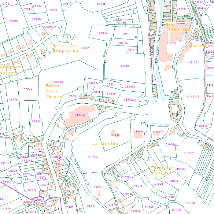
Land register plan - current situation
Land register plan - current situation corresponds to the dataset of land register from the reference database for the land register data CadGIS. The land register plan is one of the elements that make up the patrimonial documentation. It is defined as “the graphic representation and assembling on a plan of all the cadastral plan parcels of the Belgian territory”. A plan parcel, such as defined in Article 2 of the Royal Decree of 30 July 2018, is a part of Belgian territory, geographically delimited and identified by the General Administration of Patrimonial Documentation on the land register plan, which corresponds to the ground surface area of one or more patrimonial cadastral parcel(s) (real estate property as mentioned in Article 472 of the 1992 Income Tax Code in respect of which the cadastral income is fixed).
This dataset corresponds to the current situation at the time of consultation. It is composed of fourteen geometric layers. The first five are the administrative units, namely the country, the regions, the provinces, the districts and the municipalities. The sixth and seventh layers correspond to the cadastral units, divisions and sections. the eighth layer includes the cadastral blocks, the ninth, the property stones, the tenth, the addresses, the eleventh, the polders and wateringues, the twelfth, the cadastral plan parcels, the thirteenth the buildings managed by the AGDP, and the fourteenth, buildings managed by the regions. The dataset is freely downloadable via the ad hoc WFS.
Simple
- Date (Creation)
- 2020-12-15
- Date (Revision)
- 2020-12-15
- Identifier
- GAPD / 651b3dc0-71dc-11eb-89f2-3448ed25ad7c
- Status
- Completed
- Maintenance and update frequency
- Continual
- Use constraints
- Other restrictions
- Other constraints
- The licence is fully available in French (https://finances.belgium.be/sites/default/files/Licence_plan_opendata_FR.PDF) or in Dutch (https://financien.belgium.be/sites/default/files/Licentie_plan_opendata_NL.PDF).
- Access constraints
- Other restrictions
- Other constraints
- No limitations on public access
- Spatial representation type
- Vector
- Denominator
- 10000
- Metadata language
- English
- Metadata language
- Deutsch
- Metadata language
- Français
- Metadata language
- Nederlands; Vlaams
- Character set
- 8859 Part 15
- Topic category
-
- Planning cadastre
- Description
- Belgium
))
- Reference system identifier
- 31370
- Reference system identifier
- 3812
- Distribution format
-
-
Esri Shapefile
(
10.2
)
-
Esri Shapefile
(
10.2
)
- OnLine resource
-
Download service
(
OGC:WFS
)
Download service
- OnLine resource
-
Application CadGIS Viewer
(
WWW:LINK-1.0-http--link
)
Application CadGIS Viewer
- OnLine resource
-
https://opendata.fin.belgium.be/download/TechnicalSpecifications/PP-FiscSit_TechSpec_NL.pdf
(
WWW:LINK-1.0-http--link
)
Technical documentation of the product
- OnLine resource
-
View service
(
OGC:WMS
)
View service
- Hierarchy level
- Dataset
Domain consistency
- Name of measure
- INSPIRE Conformity
Conformance result
- Date (Publication)
- 2010-12-08
- Explanation
- The dataset’s compliance with the technical requirements as defined by the Commission Regulation (EU) No 1089/2010 of 23 November 2010 has not been checked
- Statement
- Land register plan - current situation is extracted from the reference database for the land register data, CadGIS, which is continuously updated. This is the most recent (current) situation of land register plan. The land register plan is continuously updated by the Patrimonial Documentation on the basis of information collected during legal changes (mutations) (on the basis of acts, declarations, judgements and rulings) and physical changes (on the basis of declarations, plans, documents, expertises and information provided by the municipalities) to the properties, as well as through improvement operations undertaken at the initiative of the Patrimonial Documentation as described in articles 5 to 8 of the Royal Decree of 30 July 2018. The land register plan is a set of data from the Geographical Information System of the Patrimonial Documentation and is mainly made up of the following categories of information: real estate property: cadastral plan parcels (property boundaries), buildings as well as certain material and equipment structures; street names, addresses, named places; reconstitutions perimeters as well as perimeters as regards polder and watering areas; administrative and cadastral limits.
- File identifier
- 65132770-71dc-11eb-b166-3448ed25ad7c XML
- Metadata language
- English
- Character set
- UTF8
- Hierarchy level
- Dataset
- Date stamp
- 2025-02-04T16:23:00
- Metadata standard name
- ISO 19115:2003/19139
- Metadata standard version
- 1.0
Overviews

Spatial extent
))
Provided by

 geo.be Metadata Catalog