geo.be Metadata Catalog
Orthophoto INSPIRE (WMS)
Orthophoto INSPIRE (WMS)
Orthofoto INSPIRE (WMS)
Orthofoto INSPIRE (WMS)
This service allows the visualization of the national orthophoto mosaics covering the entire territory of Belgium. The data is accessible via a Web Map Service (WMS).
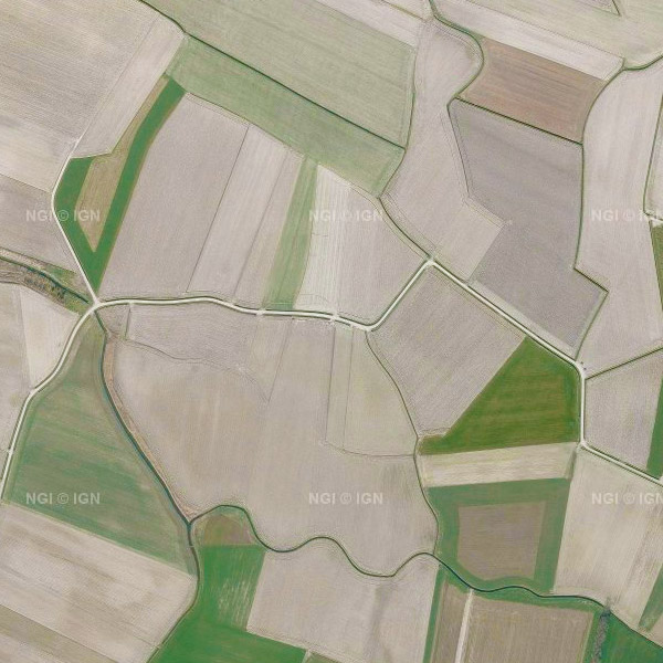
Orthophotos are aerial photographs that have been geometrically corrected (orthorectified) to eliminate distortions caused by terrain relief, lens distortion, and camera tilt. Unlike raw aerial imagery, orthophotos have a uniform scale and accurate geometry, making them suitable for cartography, measurements, and visual analysis.
This specific service includes orthophotos from 2016 up to and including 2023, derived from aerial surveys carried out by the Belgian administrative Regions. A separate layer is published for each available year, with 2023 being the most recent orthophoto coverage in this service. The national orthophoto coverage is renewed annually. The orthophoto datasets of the Regions are integrated by the National Geographic Institute (NGI) into a single national coverage. Where possible, radiometric corrections are applied to ensure smooth transitions between the data of the Regions. The resulting orthophoto mosaics are georeferenced in the Lambert 2008 coordinate system.
All orthophotos are in colour (RGB). For the 2016–2021 campaigns, the ground resolution (GSD) is 25 cm throughout Belgium. From the 2022 campaign onwards, the GSD is 25 cm in Wallonia and 15 cm in Flanders and the Brussels-Capital Region. The spatial coverage of this service is the entire Belgian territory.
For downloading the most recent orthophoto mosaics, reference is made to the associated dataset "Orthofoto INSPIRE".
Ce service permet la visualisation des mosaïques d'orthophotos nationales couvrant l'ensemble du territoire belge. Les données sont accessibles via un Web Map Service (WMS).
Les orthophotos sont des photographies aériennes corrigées géométriquement (orthorectifiées) afin d'éliminer les déformations causées par le relief du terrain, les distorsions de l'objectif et l'inclinaison de la caméra. Contrairement aux images aériennes brutes, les orthophotos ont une échelle uniforme et une géométrie précise, ce qui les rend adaptées à la cartographie, aux mesures et à l'analyse visuelle.
Ce service spécifique comprend des orthophotos de 2016 à 2023 inclus, issues de campagnes aériennes réalisées par les Régions administratives belges. Pour chaque année disponible, une couche distincte est publiée, 2023 représentant la couverture orthophotographique la plus récente dans ce service. La couverture orthophotographique nationale est renouvelée chaque année. Les jeux de données orthophotographiques des Régions sont intégrés par l'Institut Géographique National (IGN) en une couverture nationale unique. Dans la mesure du possible, des corrections radiométriques sont appliquées afin d'assurer des transitions douces entre les données des Régions. Les mosaïques d'orthophotos résultantes sont géoréférencées dans le système de coordonnées Lambert 2008.
Toutes les orthophotos sont en couleur (RVB). Pour les campagnes 2016–2021, la résolution au sol (GSD) est de 25 cm sur l'ensemble de la Belgique. À partir de la campagne 2022, la GSD est de 25 cm en Wallonie et de 15 cm en Flandre et dans la Région de Bruxelles-Capitale. La couverture spatiale de ce service est l'ensemble du territoire belge.
Pour le téléchargement des mosaïques d'orthophotos les plus récentes, il convient de se référer au jeu de données associé "Orthofoto INSPIRE".
Deze dienst maakt de visualisatie mogelijk van de nationale orthofotomozaïeken die het volledige Belgische grondgebied bedekken. De gegevens zijn toegankelijk via een Web Map Service (WMS).
Orthofoto's zijn luchtfoto's die geometrisch zijn gecorrigeerd (orthorectificatie) om vervormingen veroorzaakt door reliëf, lensvervorming en camerahoek te elimineren. In tegenstelling tot ruwe luchtbeelden hebben orthofoto's een uniforme schaal en nauwkeurige geometrie, waardoor ze geschikt zijn voor cartografie, metingen en visuele analyse.
Deze specifieke dienst omvat orthofoto's van 2016 tot en met 2023, afkomstig van luchtopnamen uitgevoerd door de Belgische administratieve Gewesten. Voor elk beschikbaar jaar wordt een afzonderlijke laag gepubliceerd, waarbij 2023 de meest recente orthofotobedekking in deze dienst is. De nationale orthofotobedekking wordt jaarlijks vernieuwd. De orthofotodatasets van de Gewesten worden door het Nationaal Geografisch Instituut (NGI) tot één nationale dekking geïntegreerd. Waar mogelijk worden radiometrische correcties toegepast om zachte overgangen tussen de data van de Gewesten te verzekeren. De resulterende orthofotomozaïeken zijn gegeorefereerd in het coördinatenstelsel Lambert 2008.
Alle orthofoto's zijn in kleur (RGB). Voor de campagnes 2016–2021 bedraagt de grondresolutie (GSD) 25 cm in heel België. Vanaf de campagne 2022 bedraagt de GSD 25 cm in Wallonië en 15 cm in Vlaanderen en het Brussels Hoofdstedelijk Gewest. De ruimtelijke dekking van deze dienst is het volledige Belgische grondgebied.
Voor het downloaden van de meest recente orthofotomozaïeken wordt verwezen naar de bijhorende dataset "Orthofoto INSPIRE".
Dieser Dienst ermöglicht die Visualisierung der nationalen Orthofotomosaike, die das gesamte belgische Staatsgebiet abdecken. Die Daten sind über einen Web Map Service (WMS) zugänglich.
Orthofotos sind Luftbilder, die geometrisch korrigiert (orthorektifiziert) wurden, um Verzerrungen durch Geländeerhebungen, Objektivverzerrungen und Kameraneigung zu beseitigen. Im Gegensatz zu unbearbeiteten Luftbildern verfügen Orthofotos über einen einheitlichen Maßstab und eine präzise Geometrie, wodurch sie sich für Kartografie, Vermessung und visuelle Analysen eignen.
Dieser spezifische Dienst umfasst Orthofotos von 2016 bis einschließlich 2023, die aus Luftaufnahmen der belgischen Verwaltungsregionen stammen. Für jedes verfügbare Jahr wird eine eigene Ebene bereitgestellt, wobei 2023 die aktuellste Orthofotoabdeckung in diesem Dienst ist. Die nationale Orthofotoabdeckung wird jährlich erneuert. Die Orthofoto-Datensätze der Regionen werden vom Nationalen Geographischen Institut (NGI) zu einer einheitlichen nationalen Abdeckung integriert. Wo möglich, werden radiometrische Korrekturen angewendet, um weiche Übergänge zwischen den Daten der Regionen zu gewährleisten. Die daraus resultierenden Orthofotomosaike sind im Koordinatensystem Lambert 2008 georeferenziert.
Alle Orthofotos sind farbig (RGB). Für die Kampagnen 2016–2021 beträgt die Bodenauflösung (GSD) 25 cm im gesamten belgischen Staatsgebiet. Ab der Kampagne 2022 beträgt die GSD 25 cm in Wallonien und 15 cm in Flandern und in der Region Brüssel-Hauptstadt. Die räumliche Abdeckung dieses Dienstes ist das gesamte belgische Staatsgebiet.
Für das Herunterladen der aktuellsten Orthofotomosaike wird auf den zugehörigen Datensatz "Orthofoto INSPIRE" verwiesen.
Simple
Information de l'identification
Identificatie info
Basisinformation
Identification info
-
Date (Création)Datum (creatie)Datum (Erstellung)Date (Creation)
- 2017-03-15
-
Date (Révision)Datum (revisie)Datum (Überarbeitung)Date (Revision)
- 2024-04-15
-
IdentificateurIdentifierIdentifikatorIdentifier
- BE.NGI-IGN / 29238f19-ac79-4a4a-a797-5490226381ec
-
Annex D4 of the European Commission Regulation 1205/2008Annexe D4 du règlement 1205/2008 de la commission européenneBijlage D4 van Verordening 1205/2008 van de Europese CommissieAnhang D4 der Verordnung 1205/2008 der Europäischen Kommission
-
Use limitationLimitation d'utilisationGebruiksbeperkingenAnwendungseinschränkungen
-
https://creativecommons.org/licenses/by/4.0/https://creativecommons.org/licenses/by/4.0/deed.frhttps://creativecommons.org/licenses/by/4.0/deed.nlhttps://creativecommons.org/licenses/by/4.0/deed.de
-
Contraintes d'accès(Juridische) toegangsrestrictieZugriffseinschränkungenAccess constraints
-
Autres restrictionsandersBenutzerdeifinierte EinschränkungenOther restrictions
-
Other constraintsAutres contraintesOverige beperkingenAndere Einschränkungen
-
No limitations on public accessPas de restrictions concernant l'accès publicGeen beperkingen op openbare toegangÖffentliche Zugang nicht beschränkt
-
Contraintes d'utilisation(Juridische) gebruiksbeperkingNutzungseinschränkungenUse constraints
-
Autres restrictionsandersBenutzerdeifinierte EinschränkungenOther restrictions
-
Other constraintsAutres contraintesOverige beperkingenAndere Einschränkungen
-
https://creativecommons.org/licenses/by/4.0/https://creativecommons.org/licenses/by/4.0/deed.frhttps://creativecommons.org/licenses/by/4.0/deed.nlhttps://creativecommons.org/licenses/by/4.0/deed.de
-
Type de serviceService TypeArt des DienstesService Type
- view
-
DescriptionDescriptionOmschrijvingBeschreibung
-
BelgiumBelgiqueBelgiëBelgien
))
Ressource couplée
Coupled Resource
Angehängte Ressource
Coupled Resource
- Operation Name
- GetCapabilities
- Identifier
- e59181f0-8469-44c6-8f6c-a5e1a4af15d5
-
Type de couplageCoupling typeArt der KopplungCoupling Type
-
ReserrétightEngTight
Opérations
Bevat operaties
Funktionen und Operationen
Contains Operations
- Operation Name
- GetCapabilities
-
CommunicationDCPDCP (Distributionsplattform)Distributed Computing Platforms
-
WebServicesWebServicesWebServicesWeb services
-
Point de connectionConnect point linkageVerknüpfungspunkt (URL)Connect Point
- https://wms.ngi.be/inspire/ortho/service ( OGC:WMS )
-
Ressource coupléeOperates onBezieht sich aufOperates On
-
Nom du système de référenceReferentiesysteem identifierIdentifikator des ReferenzsystemsReference system identifier
-
EPSG:3035
-
Nom du système de référenceReferentiesysteem identifierIdentifikator des ReferenzsystemsReference system identifier
-
EPSG:4258
-
Nom du système de référenceReferentiesysteem identifierIdentifikator des ReferenzsystemsReference system identifier
-
EPSG:3857
-
Nom du système de référenceReferentiesysteem identifierIdentifikator des ReferenzsystemsReference system identifier
-
EPSG:4326
-
Nom du système de référenceReferentiesysteem identifierIdentifikator des ReferenzsystemsReference system identifier
-
EPSG:3812
-
Ressource en ligneOnLine bronnenOnlineOnLine resource
-
View service Service de visualisation Raadpleegdienst Darstellungsdienste
(
OGC:WMS
)
View serviceService de visualisationRaadpleegdienstDarstellungsdienste
-
Ressource en ligneOnLine bronnenOnlineOnLine resource
-
View service
(
OGC:WMTS
)
View service
-
NiveauNiveau kwaliteitsbeschrijvingBezugsebeneHierarchy level
-
ServiceserviceServiceService
- Other
- Webmap Service
Cohérence du domaine de valeurs
Domain consistentie
Konsistenz des Wertebereichs
Domain consistency
-
Name of measureNom du testName of measureTestverfahren
-
INSPIRE ConformityConformité INSPIREINSPIRE ConformiteitINSPIRE Konformität
Résultat de conformité
Resultaat conformiteit met de specificatie
Konformitätsergebnis
Conformance result
-
Date (Publication)Datum (publicatie)Datum (Publikation)Date (Publication)
- 2009-08-19
-
ExplanationExplicationUitlegErklärung
-
The service described meets the technical requirements as defined by the Commission Regulation (EC) No 976/2009 of 19 October 2009Le service décrit répond aux exigences techniques telles qu’elles sont définies par le Règlement (UE) n° 976/2009 de la Commission du 19 octobre 2009De beschreven service voldoet aan de technische vereisten zoals bepaald in de Verordening (EC) nr 976/2009 van de Commissie van 19 oktober 2009Der beschriebene Dienst entspricht den technischen Anforderungen wie bestimmt in der Verordnung (EG) Nr. 976/2009 der Kommission vom 19. Oktober 2009
-
Degré de conformitéIndicatie van conformiteit met de specificatieBestandenPass
- Yes
-
Identifiant de la ficheMetadata IDMetadatensatzidentifikatorFile identifier
- 29238f19-ac79-4a4a-a797-5490226381ec XML
-
LangueTaalSpracheMetadata language
- English
-
Jeu de caractèresKaraktersetZeichensatzCharacter set
-
Utf8utf8Utf8UTF8
-
Type de ressourceHierarchisch niveauHierarchieebeneHierarchy level
-
ServiceserviceServiceService
- Hierarchy level name
- Webmap Service
-
Date des métadonnéesMetadata datumDatumDate stamp
- 2026-06-10T13:46:54
-
Metadata standard name
-
ISO 19115:2003/19139
- Metadata standard version
- 1.0
Overviews
Spatial extent
Provided by