 geo.be Metadata Catalog
Cadastral parcels - INSPIRE
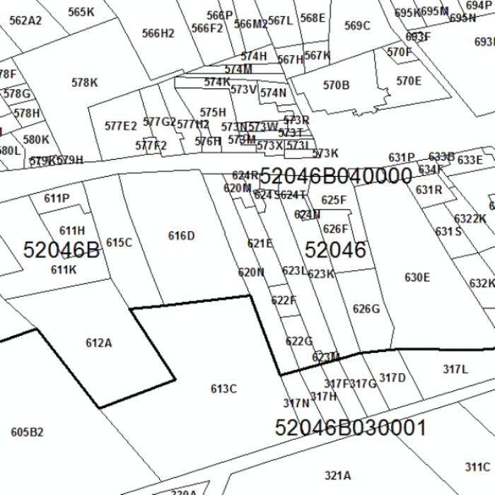
Cadastral Parcels - INSPIRE corresponds to the dataset of Belgian plan cadastral parcels complying with INSPIRE specifications. This dataset is composed of two classes. The first class contains cadastral zoning and the second class contains cadastral parcel. The entire dataset can be downloaded via the ad hoc WFS.
Simple
- Date (Publication)
- 2015-01-01
- Date (Publication)
- 2017-01-01
- Citation identifier
- GAPD / tt098dcb-f5c7-49b8-8e0b-7c3811630d85
- Presentation form
- Digital map
- Status
- On going
- Point of contact
-
Organisation name Individual name Electronic mail address Role FPS Finance - General Administration of Patrimonial Documentation (GAPD)
Gérald Henskens
Custodian
- Maintenance and update frequency
- Annually
- Keywords
-
-
Finances ATOM
-
- Keywords
-
-
HVD_cat_cadastral parcels
-
- Use constraints
- Other restrictions
- Other constraints
-
The licence is fully available in French ( https://finances.belgium.be/sites/default/files/Licence_plan_opendata_FR.PDF) or in Dutch ( https://financien.belgium.be/sites/default/files/Licentie_plan_opendata_NL.PDF).
- Access constraints
- Other restrictions
- Other constraints
- No limitations on public access
- Spatial representation type
- Vector
- Denominator
- 1000
- Language
- English
- Language
- Français
- Language
- Nederlands; Vlaams
- Language
- Deutsch
- Character set
- UTF8
- Topic category
-
- Planning cadastre
))
- Unique resource identifier
- EPSG:3812
- Codespace
-
EPSG
- Distribution format
-
Name Version GML
3.2.1
Digital transfer options
- OnLine resource
Digital transfer options
- OnLine resource
-
Protocol Linkage Name OGC:WMS https://ccff02.minfin.fgov.be/geoservices/arcgis/services/INSPIRE/CP/MapServer/WmsServer?request=GetCapabilities&service=WMS&version=1.3.0 View service as regards the cadastral parcels
- Hierarchy level
- Dataset
Conformance result
- Date (Publication)
- 2010-04-26
- Explanation
-
See the referenced specification
- Pass
- Yes
Conformance result
- Title
-
Commission regulation (EU) No 1089/2010 of 23 November 2010 implementing Directive 2007/2/EC of the European Parliament and of the Council as regards interoperability of spatial data sets and services
- Date (Publication)
- 2010-12-08
- Explanation
-
See the referenced specification
- Pass
- Yes
- Statement
-
The dataset Cadastral Parcels - INSPIRE is derived from the dataset Land register plan - situation on January 1st This is taken from the reference database for the land register data, CadGIS, whose situation is fixed on January 1st of the reference year. The land register plan is continuously updated by the Patrimonial Documentation on the basis of information collected during legal changes (mutations) (on the basis of acts, declarations, judgements and rulings) and physical changes (on the basis of declarations, plans, documents, expertises and information provided by the municipalities) to the properties, as well as through improvement operations undertaken at the initiative of the Patrimonial Documentation as described in articles 5 to 8 of the Royal Decree of July 30th 2018. The land register plan is a set of data from the Geographical Information System of the Patrimonial Documentation and is mainly made up of the following categories of information: real estate property: cadastral plan parcels (property boundaries), buildings as well as certain material and equipment structures; street names, addresses, named places; reconstitutions perimeters as well as perimeters as regards polder and watering areas; administrative and cadastral limits.
Metadata
- File identifier
- tt098dcb-f5c7-49b8-8e0b-7c3811630d85 XML
- Metadata language
- English
- Character set
- UTF8
- Hierarchy level
- Dataset
- Date stamp
- 2026-09-09T11:23:28
- Metadata standard name
-
ISO 19115:2003/19139
- Metadata standard version
-
1.0
- Metadata author
-
Organisation name Individual name Electronic mail address Role FPS Finance - General Administration of Patrimonial Documentation (GAPD)
Gérald Henskens
Point of contact
- Other language
-
Language Character encoding German Dutch; Flemish French English UTF8