geo.be Metadata Catalog
Top10Vector (WMS)
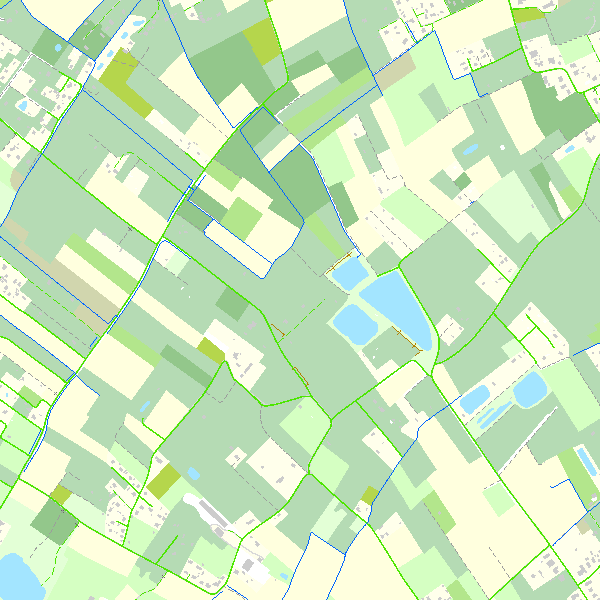
This webservice allows the Top10Vector product, containing topographical vector data covering the whole of Belgium, to be visualised. The product consists of 35 feature types grouped into 8 different topics: ‘Constructions, ‘Particular zones, ‘Land cover and vegetation, ‘High-voltage network, ‘Hydrography’, ‘Local relief’, ‘Railway network’ and ‘Road network’.
The link to the webservice is available under 'Access' at the bottom of this page.
Simple
- Date (Revision)
- 2026-01-23
- Date (Publication)
- 2015-02-10
- Citation identifier
- BE.NGI-IGN / fa4df595-0413-4f33-a54f-fb048426576d
- Point of contact
-
Organisation name Individual name Electronic mail address Role National Geographic Institute
Jeanne Annendyck
Originator
-
Annex D4 of the European Commission Regulation 1205/2008
- Keywords
-
-
Federal viewer
-
- Use limitation
- https://creativecommons.org/licenses/by/4.0/
- Access constraints
- Other restrictions
- Other constraints
- No limitations on public access
- Use constraints
- Other restrictions
- Other constraints
- https://creativecommons.org/licenses/by/4.0/
- Service Type
- view
- Description
-
Belgium
))
- Coupled Resource
-
Operation Name Scoped name Identifier GetCapabilities
undefined 03417a9e-ef77-4da7-ba1d-116912c0c49a
GetCapabilities
undefined a9ab14e0-adbc-452e-9042-3614a123c97c
GetCapabilities
undefined c6c6d674-e3c5-47a9-8398-f4e1082d3e8e
GetCapabilities
undefined 098a4670-27e5-4c21-9a28-5e47ea1d1173
GetCapabilities
undefined 1f4296b0-76f6-4f1b-8880-315406b367e1
GetCapabilities
undefined f1e1b0d5-b8b3-4b6e-a2c7-e13e36c84315
GetCapabilities
undefined a71223fd-0bef-44b5-afe4-e3cb3e58b2dc
GetCapabilities
undefined b9b31789-ac81-4b3e-8d38-21b1fbe5aa69
GetCapabilities
e0fdc885-8851-482e-80c9-6a0ba3709761
- Coupling Type
- Tight
- Contains Operations
-
Operation Name Distributed Computing Platforms Connect Point GetCapabilities
Web services https://data.geo.be/ws/top10vector/wms?service=wms&request=getcapabilities&version=1.3.0
Digital transfer options
- OnLine resource
-
Protocol Linkage Name OGC:WMS
https://data.geo.be/ws/top10vector/wms?service=wms&request=getcapabilities&version=1.3.0
- Hierarchy level
- Service
- Other
-
Webmap service
Domain consistency
- Name of measure
-
INSPIRE Conformity
Conformance result
- Date (Publication)
- 2009-08-19
- Explanation
-
The service described meets the technical requirements as defined by the Commission Regulation (EC) No 976/2009 of 19 October 2009
- Pass
- Yes
Metadata
- File identifier
- fa4df595-0413-4f33-a54f-fb048426576d XML
- Metadata language
- English
- Character set
- UTF8
- Hierarchy level
- Service
- Hierarchy level name
-
Webmap service
- Date stamp
- 2026-07-08T09:27:38
- Metadata standard name
-
ISO 19115:2003/19139
- Metadata standard version
-
1.0
- Metadata author
-
Organisation name Individual name Electronic mail address Role National Geographic Institute
Point of contact
- Other language
-
Language Character encoding French Dutch; Flemish German English UTF8