geo.be Metadata Catalog
Orthophoto INSPIRE
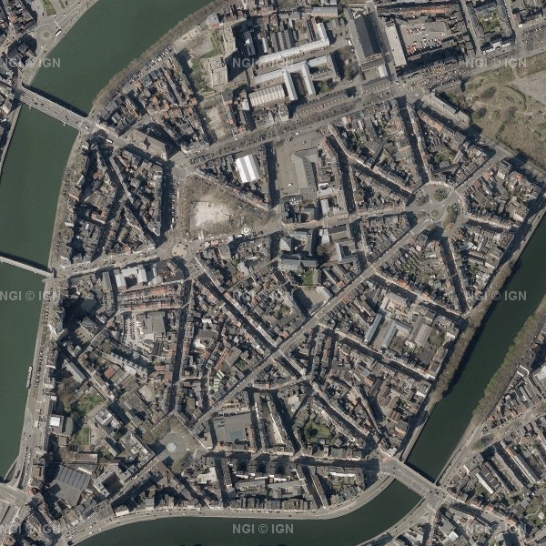
This dataset contains the most recent orthophoto mosaics for the Belgian territory.
Orthophotos are aerial photographs that have been geometrically corrected (orthorectification) to eliminate distortions caused, among other things, by terrain, the camera lens and the camera viewing angle. As a result, they have accurate geometry and can be used for cartography, measurements and visual analysis, among other applications.
The orthophoto data are provided by the Belgian administrative Regions and integrated by the National Geographic Institute (NGI) into a single national coverage. The transitions between the orthophotos from the different Regions are carefully adjusted to create a seamless and visually homogeneous whole.
The dataset is updated annually with the most recent orthophoto data. The aim is to provide complete national orthophoto coverage every year. However, not every year provides complete coverage of Belgium. In such cases, the national coverage is supplemented with orthophotos from previous years.
The dataset is updated in phases. For the 2026 edition, orthophoto tiles for Wallonia are currently available. The data for Flanders will be added as soon as they become available. The 2026 data can currently be downloaded, but have not yet been included in the WMS/WMTS web services.
All orthophotos are colour images (RGB). The ground sampling distance (GSD) is 25 cm in Wallonia and 12.5 cm in Flanders and the Brussels-Capital Region. Since 2026, the orthophoto mosaics have been divided into tiles according to the NGI 25K grid, a fixed geographical grid covering the Belgian territory.
The data can be downloaded as compressed JPEG2000 files (JP2), together with the corresponding world file (.j2w) and metadata describing the extent. The dataset is INSPIRE-compliant.
Simple
- Date (Creation)
- 2020-10-21
- Date (Revision)
- 2026-10-06
- Citation identifier
- BE.NGI-IGN / e59181f0-8469-44c6-8f6c-a5e1a4af15d5
- Status
- Completed
- Point of contact
-
Organisation name Individual name Electronic mail address Role National Geographic Institute
Anke Bracke
Custodian
- Maintenance and update frequency
- Annually
- Keywords
-
-
HVD_cat_orthoimagery
-
- Use constraints
- Other restrictions
- Other constraints
- https://creativecommons.org/licenses/by/4.0/
- Access constraints
- Other restrictions
- Other constraints
- No limitations on public access
- Use limitation
- https://creativecommons.org/licenses/by/4.0/
- Spatial representation type
- Grid
- Distance
- 0.125 m
- Language
- Deutsch
- Language
- Nederlands; Vlaams
- Language
- Français
- Character set
- 8859 Part 15
- Topic category
-
- Imagery base maps earth cover
- Description
-
Belgium
))
- Unique resource identifier
- EPSG:3812
- Distribution format
-
Name Version jp2
Digital transfer options
Digital transfer options
- OnLine resource
-
Protocol Linkage Name WWW:DOWNLOAD-1.0-http--download
https://ac.ngi.be/catalogue/getopenaccess/ngi-standard-open/Rasterdata/Orthos
Digital transfer options
- OnLine resource
-
Protocol Linkage Name WWW:DOWNLOAD-1.0-http--download
https://ac.ngi.be/catalogue/getopenaccess/ngi-standard-open/Rasterdata/INSPIRE/Orthophotos_gml_L08.zip
Digital transfer options
- OnLine resource
-
Protocol Linkage Name OGC:WMS https://wms.ngi.be/inspire/ortho/service?request=GetCapabilities&service=WMS&version=1.3.0 INSPIRE WMS
Digital transfer options
- OnLine resource
-
Protocol Linkage Name WWW:LINK-1.0-http--link
https://ngi.be/aanbod/kaarten-en-fotos/luchtfotos-orthofotos/ https://ngi.be/aanbod/kaarten-en-fotos/luchtfotos-orthofotos/
- Hierarchy level
- Dataset
Domain consistency
- Name of measure
-
INSPIRE Conformity
Conformance result
- Date (Publication)
- 2010-12-08
- Explanation
-
The dataset’s compliance with the technical requirements as defined by the Commission Regulation (EU) No 1089/2010 of 23 November 2010 has not been checked
- Pass
- Yes
- Statement
-
The orthophotos are available as compressed JPEG2000 (JP2) files in Lambert 2008 and are tiled according to the NGI 25K grid.
Metadata
- File identifier
- e59181f0-8469-44c6-8f6c-a5e1a4af15d5 XML
- Metadata language
- English
- Character set
- UTF8
- Hierarchy level
- Dataset
- Date stamp
- 2026-10-08T08:25:38
- Metadata standard name
-
ISO 19115:2003/19139
- Metadata standard version
-
1.0
- Metadata author
-
Organisation name Individual name Electronic mail address Role National Geographic Institute
Floor Van Damme
Point of contact
- Other language
-
Language Character encoding French UTF8 Dutch; Flemish UTF8 German UTF8 English UTF8