geo.be Metadata Catalog
Top25Map
Top25Map
Top25Map
Top25Map
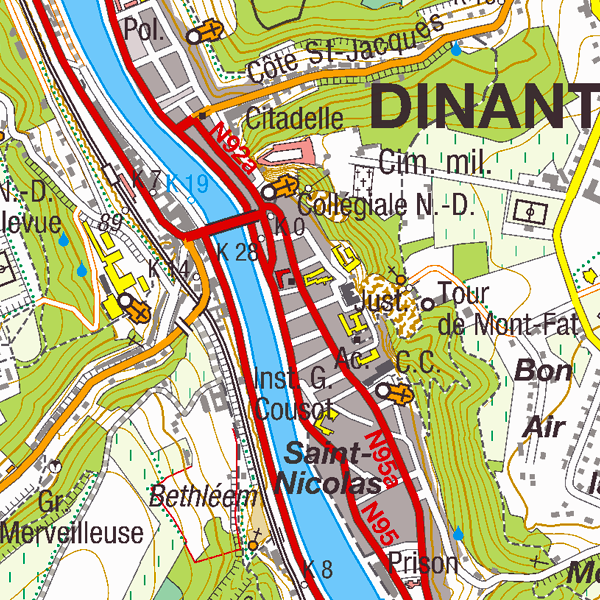
Top25Map is a digital version of the NGI’s topographic cartography on a scale of 1:25 000. These images result from the symbolisation of the objects and themes which are present in the topo-geographic inventory of the Belgian territory (ITGI), which is built and kept up-to-date by the NGI. Top25Map contains all usual themes of the NGI’s cartographic products (land use, transport, hydrography, buildings and constructions, relief,…), as well as the map lettering and the toponyms. The Top25Map cartography is appropriate to hiking.
Top25Map est une version numérique de la cartographie topographique à l’échelle 1:25 000 de l’IGN. Ces images résultent de la symbolisation des objets et des thèmes présents dans l’inventaire topogéographique du territoire belge (ITGI) qui est élaboré et mis à jour par l’Institut géographique national. Top25Map reprend tous les thèmes habituels des produits cartographiques de l’IGN (Occupation du sol, transports, hydrographie, bâtiments et constructions, relief …) , y compris les écritures et toponymes. La cartographie reprise dans Top25Map est appropriée à la randonnée.
Top25Map is een digitale versie van de topografische cartografie op schaal 1 :25 000 van het NGI. Deze beelden worden gemaakt door symbolisatie van de objecten en de thema’s in de topo-geografische inventaris van het Belgische grondgebied (ITGI), die wordt gemaakt en bijgehouden door het NGI. Top25Map bevat alle gewone thema’s van de kaartproducten van het NGI (bodemgebruik, transport, hydrografie, gebouwen en constructies, reliëf,…) met inbegrip van de geschriften en de toponiemen. De kaartweergave van Top25Map is geschikt voor wandeltochten.
Top25Map ist eine digitale Version der topographischen Kartographie im Maßstab 1:25 000 des NGI. Diese Bilder sind das Resultat der Symbolisierung der Objekte und Themen, die im topogeographischen Inventar des belgischen Territoriums (ITGI) vorhanden sind, d. h. das Inventar, das vom Nationalen Geographischen Institut erstellt und aktualisiert wird. Top25Map nimmt alle gebräuchliche Themen der Kartenprodukte des NGI (Bodennutzung, Transporte, Hydrographie, Gebäude und Bauten, Relief, usw.) einschließlich Kartenbeschriftung und Toponyme auf. Die Kartographie von Top25Map ist für Wanderungen geeignet.
Simple
-
Date (Création)Datum (creatie)Datumsangaben (Erstellung)Date (Creation)
- 2016-09-15
-
Date (Révision)Datum (revisie)Datumsangaben (Überarbeitung)Date (Revision)
- 2016-09-15
-
IdentificateurIdentifierIdentifikatorCitation identifier
- BE.NGI-IGN / 95cfdd8f-808e-11e9-a3ad-482ae30f98d9
-
EtatStatusBearbeitungsstatusStatus
-
FinalisécompleetAbgeschlossenCompleted
- Point of contact
-
Organisation name Individual name Electronic mail address Role National Geographic Institute
Institut géographique national
Nationaal Geografisch Instituut
Nationales geographisches Institut
Frédérique Spitaels
GestionnairebeheerderVerwalterCustodian
-
Fréquence de mise à jourHerzieningsfrequentieÜberarbeitungsintervallMaintenance and update frequency
-
Trimestrielle1 x per kwartaalVierteljährlichQuarterly
-
GEMET - INSPIRE themes, version 1.0
-
-
Utility and governmental servicesServices d'utilité publique et services publicsNutsdiensten en overheidsdienstenVersorgungswirtschaft und staatliche Dienste
-
Transport networksRéseaux de transportVervoersnetwerkenVerkehrsnetze
-
Land useUsage des solsLandgebruikBodennutzung
-
Land coverOccupation des terresBodemgebruikBodenbedeckung
-
HydrographyHydrographieHydrografieGewässernetz
-
Geographical namesDénominations géographiquesGeografische namenGeografische Bezeichnungen
-
Administrative unitsUnités administrativesAdministratieve eenhedenVerwaltungseinheiten
-
ElevationAltitudeHoogteHöhe
-
BuildingsBâtimentsGebouwenGebäude
-
-
Use limitationLimitation d'utilisationGebruiksbeperkingenAnwendungseinschränkungen
-
https://creativecommons.org/licenses/by/4.0/https://creativecommons.org/licenses/by/4.0/deed.frhttps://creativecommons.org/licenses/by/4.0/deed.nlhttps://creativecommons.org/licenses/by/4.0/deed.de
-
Contraintes d'accès(Juridische) toegangsrestrictieZugriffseinschränkungenAccess constraints
-
Autres restrictionsandersBenutzerdefinierte EinschränkungenOther restrictions
-
Other constraintsAutres contraintesOverige beperkingenAndere Einschränkungen
-
No limitations on public accessPas de restrictions concernant l'accès publicGeen beperkingen op openbare toegangÖffentliche Zugang nicht beschränkt
-
Contraintes d'utilisation(Juridische) gebruiksbeperkingNutzungseinschränkungenUse constraints
-
Autres restrictionsandersBenutzerdefinierte EinschränkungenOther restrictions
-
Other constraintsAutres contraintesOverige beperkingenAndere Einschränkungen
-
https://creativecommons.org/licenses/by/4.0/https://creativecommons.org/licenses/by/4.0/deed.frhttps://creativecommons.org/licenses/by/4.0/deed.nlhttps://creativecommons.org/licenses/by/4.0/deed.de
-
Type de représentation spatialeRuimtelijk schemaRäumliche DarstellungsartSpatial representation type
-
RastergridRaster, GitterGrid
-
Distance de résolutionAfstandDistanzDistance
- 1 m
-
Langue de la ressourceTaalSpracheLanguage
- Deutsch
-
Langue de la ressourceTaalSpracheLanguage
- Nederlands; Vlaams
-
Langue de la ressourceTaalSpracheLanguage
- Français
-
Encodage des caractèresKaraktersetZeichensatzCharacter set
-
8859part158859part158859part158859 Part 15
-
Catégorie ISOOnderwerpISO-ThematikTopic category
-
-
Infrastructures de transporttransportVerkehrswesenTransportation
-
Constructions et ouvrages(civiele) structurenBauwerkeStructure
-
Limites politiques et administrativesgrenzenGrenzenBoundaries
-
-
DescriptionDescriptionOmschrijvingBeschreibung
-
Belgium
Belgique
België
Belgien
))
- Distribution format
-
Name Version TIFF
Options de transfert numérique
Digitale leverings opties
Digitale Transferoptionen
Digital transfer options
- OnLine resource
-
Protocol Linkage Name OGC:WMS
https://wms.ngi.be/inspire/topomaps/service?service=wms&request=getcapabilities&version=1.3.0
Options de transfert numérique
Digitale leverings opties
Digitale Transferoptionen
Digital transfer options
- OnLine resource
-
Protocol Linkage Name WWW:LINK-1.0-http--link
https://ac.ngi.be/catalogue/getopenaccess/ngi-specs/Top25Map_ProductSpecification_NL.pdf
Options de transfert numérique
Digitale leverings opties
Digitale Transferoptionen
Digital transfer options
- OnLine resource
-
Protocol Linkage Name https://ac.ngi.be/catalogue/order/ngi-standard/Rasterdata/Top25Map?language=en
Options de transfert numérique
Digitale leverings opties
Digitale Transferoptionen
Digital transfer options
- OnLine resource
-
Protocol Linkage Name https://shop.ngi.be/nl/bekijk-op-de-kaart/?x=658521.5&y=633841.5&r=417.44&c=topo_25
-
NiveauNiveau kwaliteitsbeschrijvingBezugsebeneHierarchy level
-
Jeu de donnéesdatasetDatenbestandDataset
Cohérence du domaine de valeurs
Domain consistentie
Konsistenz des Wertebereichs
Domain consistency
-
Name of measureNom du testName of measureTestverfahren
-
INSPIRE Conformity
Conformité INSPIRE
INSPIRE Conformiteit
INSPIRE Konformität
Résultat de conformité
Resultaat conformiteit met de specificatie
Konformitätsergebnis
Conformance result
-
Date (Publication)Datum (publicatie)Datumsangaben (Publikation)Date (Publication)
- 2010-12-08
-
ExplanationExplicationUitlegErklärung
-
The dataset’s compliance with the technical requirements as defined by the Commission Regulation (EU) No 1089/2010 of 23 November 2010 has not been checked
La conformité du jeu de donnée aux exigences techniques telles qu’elles sont définies par le Règlement (UE) n° 1089/2010 de la Commission du 23 novembre 2010 n'a pas été testée
De overeenstemming van de dataset met de technische vereisten zoals bepaald in de Verordening (EU) nr 1089/2010 van de Commissie van 23 november 2010 werd niet gecontroleerd
Die Kongruenz des Datensatzes mit den technischen Anforderungen wie bestimmt in der Verordnung (EG) Nr. 1089/2010 der Kommission vom 23. November 2010 wurde nicht geprüft
-
StatementGénéralités sur la provenanceAlgemene beschrijving herkomstErläuterung
-
Automatic symbolisation of the Topo-geographic Inventory of the territory (reference database, in its generalised version) of the National Geographic Institute.
Symbolisation automatique de l'Inventaire Topogéographique du territoire (DB de référence, dans sa version généralisée), de l'Institut géographique national.
Automatische symbolisatie van de Topo-Geografische Inventaris van het grondgebied (referentiedatabank, in haar gegeneraliseerde versie) van het Nationaal Geografisch Instituut.
Automatische Symbolisierung des topogeographischen Inventars des belgischen Territoriums (Bezugsdatenbank in ihrer generalisierten Version) des Nationalen Geographischen Instituts.
Metadata
-
Identifiant de la ficheMetadata IDMetadatensatzidentifikatorFile identifier
- 95cfdd8f-808e-11e9-a3ad-482ae30f98d9 XML
-
LangueTaalSpracheMetadata language
- English
-
Jeu de caractèresKaraktersetZeichensatzCharacter set
-
Utf8utf8Utf8UTF8
-
Type de ressourceHierarchisch niveauHierarchieebeneHierarchy level
-
staticMapstaticMapstaticMapstaticMap
- Hierarchy level name
-
staticMap
-
Date des métadonnéesMetadata datumDatumDate stamp
- 2026-02-03T11:17:02
-
Metadata standard name
-
ISO 19115:2003/19139
- Metadata standard version
-
1.0
- Metadata author
-
Organisation name Individual name Electronic mail address Role National Geographic Institute
Institut géographique national
Nationaal Geografisch Instituut
Nationales geographisches Institut
Floor Van Damme
Point de contactcontactpuntAnsprechpartnerPoint of contact
- Other language
-
Language Character encoding FrançaisFransFranzösischFrenchNéerlandais; flamandNederlands; VlaamsNiederländischDutch; FlemishAllemandDuitsDeutschGermanAnglaisEngelsEnglischEnglishUtf8utf8Utf8UTF8