 geo.be Metadata Catalog
SUVIM station network
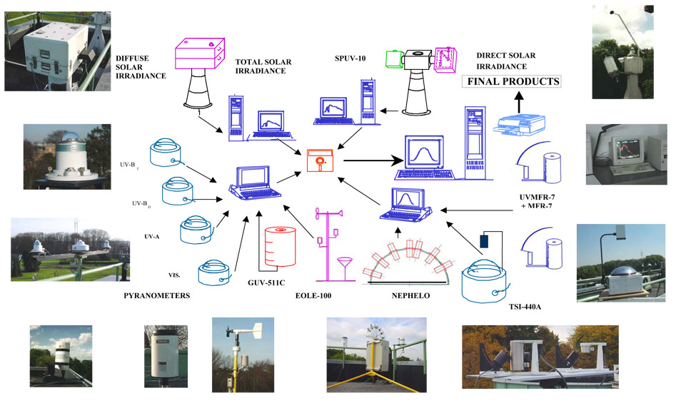
The Solar Ultraviolet - Visible Irradiance Monitoring network (SUVIM) is formed of observation stations operated by the Royal Belgian Institute for Space Aeronomy (IASB-BIRA). At each station, UV solar radiation is measured by several instruments. The network produces UV indices, solar irradiances and ancillary measurements such as meteorological conditions at the stations in quasi-real time. The SUVIM Station Network dataset includes information on the stations. It does not include the measured data, which form the SUVIM Observations dataset.
Simple
- Date (Creation)
- 1993-03-29
- Citation identifier
- BE.BIRA-IASB / 59129f4b-a61b-467c-9b41-1f92e4338151
- Status
- On going
- Point of contact
-
Organisation name Individual name Electronic mail address Role Royal Belgian Institute for Space Aeronomy (IASB-BIRA)
Author
-
CF Standard Name Table
-
-
solar_irradiance
-
atmosphere_mole_content_of_ozone
-
-
International Commission on Illumination (CIE)
-
-
erythemal dose
-
direct solar irradiance
-
UV-A
-
UV-B
-
global UV index
-
ultraviolet radiation
-
UV radiation
-
-
CF list of Standardized Region Names
-
-
antarctica
-
-
Getty Thesaurus of Geographic Names (TGN)
-
-
Belgium
-
Luxembourg
-
Antarctica
-
- Use constraints
- Other restrictions
- Other constraints
-
•The custodian of the resource holds the rights of property (including the rights of intellectual property) to the geographic files
•The custodian grants the user the right to use the data for his internal use.
•Commercial use of the data under any form is strictly forbidden
•Custodian’s name must be mentioned each time the data are being used publically.
- Access constraints
- Other restrictions
- Other constraints
- No limitations on public access
- Use limitation
-
•The custodian of the resource holds the rights of property (including the rights of intellectual property) to the geographic files•The custodian grants the user the right to use the data for his internal use.•Commercial use of the data under any form is strictly forbidden•Custodian’s name must be mentioned each time the data are being used publically.
- Spatial representation type
- Vector
- Denominator
- 10000
- Language
- English
- Topic category
-
- Climatology, meteorology, atmosphere
- Environment
- Geoscientific information
- Health
- Description
-
Belgium + Grand Duchy of Luxembourg + Antarctica
))

- Unique resource identifier
- EPSG:4326
- Codespace
-
EPSG
- Distribution format
-
Name Version Esri Shapefile
Digital transfer options
- OnLine resource
-
Protocol Linkage Name WWW:LINK-1.0-http--link
http://uvindex.aeronomie.be/ uvindex.aeronomie.be
Digital transfer options
- OnLine resource
-
Protocol Linkage Name WWW:DOWNLOAD-1.0-http--download
https://ac.ngi.be/remoteclient-open/GeoBePartners-open/BIRA-IASB/59129f4b-a61b-467c-9b41-1f92e4338151_x-shapefile_4326.zip
Digital transfer options
- OnLine resource
-
Protocol Linkage Name OGC:WMS
https://data.geo.be/ws/aeronomie/wms?request=getcapabilities&service=wms INSPIRE WMS
Digital transfer options
- Hierarchy level
- Dataset
Extent
- Dataset
-
SUVIM station network
Domain consistency
- Name of measure
-
INSPIRE Conformity
Conformance result
- Date (Publication)
- 2010-12-08
- Explanation
-
The dataset described does not fill the technical requirements sustaining the interoperability of data sets and services, as stipulated in the Commission Regulation (EU) No 1089/2010 of 23 November 2010
- Pass
- Yes
- Statement
-
Archives:
The SUVIM Observations data are archived at (and are available from)
1. the Royal Belgian Institute for Space Aeronomy (IASB-BIRA) – http://uvindex.aeronomie.be/
2. the European UV Database – http://uv.fmi.fi/uvdb/
History of instruments in operation at each station in Belgium and type of data available:
IASB-BIRA – Uccle (BRU)
1. Spectral data (Global Solar Spectral Irradiance)
Wavelength range : 280 -600 nm
Field of view : 2 pi sr
Period : since March 29, 1993
2. Broadband data
UV-B meter (total) since February 2, 1995
UV-B meter (diffuse) since July 16, 1996
UV-A meter since May 11, 1995
pyranometer since July 25, 1995
3. Filter radiometradata
10-Channels SPUV-10 since March 21, 1996
7-Channels UVMFR-7 since October 14, 1999
7-Channels MFR-7 since December 18, 2003
5-Channels GUV-551C since May 23, 1996
6-Channels GUV-2511 since June 3, 2005
4. Cloud measurements
TSI (Total Sky Imager) since December 7, 1999
CIR (Cloud Infrared Radiometer) since March 1, 2002
5. Meteorological measurements
Eole 100/200 since May 27, 1997
6. Sunshine Duration
SDM MS-093 since June 16, 2010
Euro Space Center – REDU (RED)
1. Broadband data UV-B meter since June 15, 2004
UV-A meter since June 15, 2004
Pyranometer since June 15, 2004
2. Filter radiometer data 5-Channels GUV 511c since March 10, 2005
3. Cloud measurements CIR-4 /CIR-4V since December 7, 2006
4. Meteorological measurements Eole 200 since March 3, 2005
5. Sunshine Duration SDM MS-093 since August 1, 2011
Earth Explorer – Ostend (LIT)
1. Broadband data UV-B meter since April 4, 2006
UV-A meter since April 4, 2006
Pyranometer since April 4, 2006
2. Filter radiometer data 6-Channels GUV 2511 since June 26, 2006
3. Cloud measurements CIR-4/CIR-4V since December 21, 2006
4. Meteorological measurements Eole 200 since April 4, 2006
Virton – City Hall (GAU)
1. Broadband data UV-B meter since December 11, 2007
UV-A meter since December 11, 2007
Pyranometer since December 11, 2007
2. Filter radiometer data 6-Channels GUV 2511 since February 19, 2008
3. Cloud measurements CIR-4/CIR-4V since December 11, 2007
4. Meteorological measurements Eole 200 since December 11, 2007
VITO – Mol (CAM)
1. Broadband data UV-B meter since December 16, 2008
UV-A meter since December 16, 2008
Pyranometer since December 16, 2008
2. Filter radiometer data 6-Channels GUV 2511 since February 19, 2008
3. Cloud measurements CIR-4/CIR-4V since December 16, 2008
4. Meteorological measurements Eole 200 since December 16, 2008
Hautes Fagnes Scientific Station - Mont Rigi (FAG)
1. Broadband data UV-B meter since November 8, 2011
UV-A meter since November 8, 2011
Pyranometer since November 8, 2011
2. Filter radiometer data 6-Channels GUV 2511 since November 8, 2011
3. Cloud measurements CIR-4V since November 8, 2011
4. Meteorological measurements Eole 200 since November 8, 2011
Metadata
- File identifier
- 59129f4b-a61b-467c-9b41-1f92e4338151 XML
- Metadata language
- English
- Character set
- UTF8
- Hierarchy level
- Dataset
- Date stamp
- 2026-07-09T14:57:02
- Metadata author
-
Organisation name Individual name Electronic mail address Role Royal Belgian Institute for Space Aeronomy (IASB-BIRA)
Point of contact
- Other language
-
Language Character encoding French Dutch; Flemish German English UTF8