geo.be Metadata Catalog
Cadastral parcels - monthly situation
Parcelles cadastrales – situation mensuelle
Kadastrale percelen - maandelijkse toestand
Katasterparzellen - monatlicher Stand
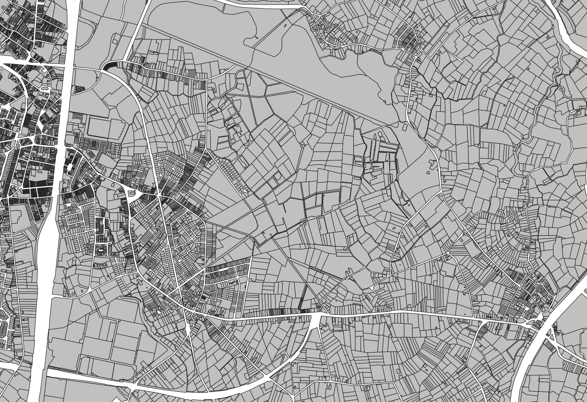
Cadastral parcels - monthly situation corresponds to the dataset of the monthly situation of the cadastral parcels layer from the Land Register plan. The dataset is composed of two classes. The first class contains the geometries of the cadastral parcels; the second is a class without geometry and corresponds to a code table of the different fiscal situations used in the first class. The dataset can be freely downloaded as a zipped shapefiles.
Parcelles cadastrales – situation mensuelle correspond au jeu de données de la situation mensuelle de la couche des parcelles cadastrales du plan parcellaire cadastral. Ce jeu de données est composé de 2 classes. La première reprend les géométries des parcelles cadastrales et leur données attributaires ; la seconde est une classe sans géométrie et correspond à une table de code des différentes situations fiscales reprises dans la première classe. Le jeu de données est librement téléchargeable, sous forme de shapefiles zippés.
Kadastrale percelen – maandelijkse toestand komt overeen met de dataset van de maandelijkse toestand van het kadastrale percelen laag van het kadastraal percelenplan. Deze dataset bestaat uit twee klassen. De eerste klasse bevat de geometrieën van de kadastrale percelen; de tweede klasse is een klasse zonder geometrie en komt overeen met een code tabel van de verschillende fiscale toestanden gebruikt in de eerste klasse. De dataset is vrij te downloaden, in de vorm van gezipte shapefiles.
Katasterparzellen - monatlicher Stand versteht man ein Datenpaket, das der monatlicher Stand der die Schicht der Katasterparzellen aus dem Katasterplan. Dieses Datenpaket besteht aus zwei Klassen. Die erste enthält die Geometrien der Katasterparzellen und ihre Attributdaten; die zweite ist eine Klasse ohne Geometrie und entspricht einer Codetabelle der verschiedenen steuerlichen Situationen, die in der ersten Klasse verwendet werden. Das Datenpaket kann in Form von komprimierten Shapefile-Dateien frei heruntergeladen werden.
Simple
-
Date (Création)Datum (creatie)Datumsangaben (Erstellung)Date (Creation)
- 2023-03-24
-
Date (Révision)Datum (revisie)Datumsangaben (Überarbeitung)Date (Revision)
- 2025-08-04
-
IdentificateurIdentifierIdentifikatorCitation identifier
- GADP / 1d797df0-c988-11ed-abc3-0050569393d1
-
EtatStatusBearbeitungsstatusStatus
-
FinalisécompleetAbgeschlossenCompleted
- Point of contact
-
Organisation name Individual name Electronic mail address Role FPS Finance - General Administration of Patrimonial Documentation (GAPD)
SPF Finances - Administration Générale de la Documentation Patrimoniale (AGDP)
FOD Financien - Algemene Administratie van de Patrimoniumdocumentatie (AAPD)
FOD Finanzen - Generalverwaltung Vermögensdokumentation (GVVD)
Gérald Henskens
GestionnairebeheerderVerwalterCustodian
-
Fréquence de mise à jourHerzieningsfrequentieÜberarbeitungsintervallMaintenance and update frequency
-
MensuellemaandelijksMonatlichMonthly
-
Contraintes d'utilisation(Juridische) gebruiksbeperkingNutzungseinschränkungenUse constraints
-
Autres restrictionsandersBenutzerdefinierte EinschränkungenOther restrictions
-
Other constraintsAutres contraintesOverige beperkingenAndere Einschränkungen
-
The licence is fully available in French ( https://finances.belgium.be/sites/default/files/Licence_plan_opendata_FR.PDF) or in Dutch ( https://financien.belgium.be/sites/default/files/Licentie_plan_opendata_NL.PDF).
Le contenu de la licence est intégrablement consultable ici : https://finances.belgium.be/sites/default/files/Licence_plan_opendata_FR.PDF.
de inhoud van de licentie is hier volledig doorzoekbaar: https://financien.belgium.be/sites/default/files/Licentie_plan_opendata_NL.PDF.
Die Lizenz ist vollständig in Französisch ( https://finances.belgium.be/sites/default/files/Licence_plan_opendata_FR.PDF.) und Niederländisch (( https://financien.belgium.be/sites/default/files/Licentie_plan_opendata_NL.PDF) verfügbar.
-
Contraintes d'accès(Juridische) toegangsrestrictieZugriffseinschränkungenAccess constraints
-
Autres restrictionsandersBenutzerdefinierte EinschränkungenOther restrictions
-
Other constraintsAutres contraintesOverige beperkingenAndere Einschränkungen
-
No limitations on public accessPas de restrictions concernant l'accès publicGeen beperkingen op openbare toegangÖffentliche Zugang nicht beschränkt
-
Type de représentation spatialeRuimtelijk schemaRäumliche DarstellungsartSpatial representation type
-
VecteurvectorVektorVector
-
Dénominateur de l'échelleToepassingsschaalMaßstabszahlDenominator
- 10000
-
Langue de la ressourceTaalSpracheLanguage
- Deutsch
-
Langue de la ressourceTaalSpracheLanguage
- Français
-
Langue de la ressourceTaalSpracheLanguage
- Nederlands; Vlaams
-
Langue de la ressourceTaalSpracheLanguage
- English
-
Encodage des caractèresKaraktersetZeichensatzCharacter set
-
8859part158859part158859part158859 Part 15
-
Catégorie ISOOnderwerpISO-ThematikTopic category
-
-
Cadastre, aménagementplanning kadasterPlanungsunterlagen, KatasterPlanning cadastre
-
-
DescriptionDescriptionOmschrijvingBeschreibung
-
Belgium
Belgique
België
Belgien
))
- Distribution format
-
Name Version Esri Shapefile10.2
Options de transfert numérique
Digitale leverings opties
Digitale Transferoptionen
Digital transfer options
- OnLine resource
-
Protocol Linkage Name WWW:LINK-1.0-http--link
https://opendata.fin.belgium.be/download/TechnicalSpecifications/CadastralParcelsMonthlySituation_20250804_TechSpec_FR.pdf WWW:LINK-1.0-http--link
https://opendata.fin.belgium.be/download/ATOM/9bb31275-18bc-4bdc-96e9-55c9e1edd9eb-en.xml Download service non-INSPIRE datasets
ATOM
https://opendata.fin.belgium.be/download/ATOM/1d797df0-c988-11ed-abc3-0050569393d1-en.xml
Options de transfert numérique
Digitale leverings opties
Digitale Transferoptionen
Digital transfer options
Options de transfert numérique
Digitale leverings opties
Digitale Transferoptionen
Digital transfer options
Options de transfert numérique
Digitale leverings opties
Digitale Transferoptionen
Digital transfer options
- OnLine resource
-
Protocol Linkage Name WWW:DOWNLOAD-1.0-http--download
https://financien.belgium.be/nl/experten_partners/open-patrimoniumdata/datasets/downloadportaal
-
NiveauNiveau kwaliteitsbeschrijvingBezugsebeneHierarchy level
-
Jeu de donnéesdatasetDatenbestandDataset
Cohérence du domaine de valeurs
Domain consistentie
Konsistenz des Wertebereichs
Domain consistency
-
Name of measureNom du testName of measureTestverfahren
-
INSPIRE Conformity
Conformité INSPIRE
INSPIRE Conformiteit
INSPIRE Konformität
Résultat de conformité
Resultaat conformiteit met de specificatie
Konformitätsergebnis
Conformance result
-
Date (Publication)Datum (publicatie)Datumsangaben (Publikation)Date (Publication)
- 2010-12-08
-
ExplanationExplicationUitlegErklärung
-
The dataset’s compliance with the technical requirements as defined by the Commission Regulation (EU) No 1089/2010 of 23 November 2010 has not been checked
La conformité du jeu de donnée aux exigences techniques telles qu’elles sont définies par le Règlement (UE) n° 1089/2010 de la Commission du 23 novembre 2010 n'a pas été testée
De overeenstemming van de dataset met de technische vereisten zoals bepaald in de Verordening (EU) nr 1089/2010 van de Commissie van 23 november 2010 werd niet gecontroleerd
Die Kongruenz des Datensatzes mit den technischen Anforderungen wie bestimmt in der Verordnung (EG) Nr. 1089/2010 der Kommission vom 23. November 2010 wurde nicht geprüft
-
StatementGénéralités sur la provenanceAlgemene beschrijving herkomstErläuterung
-
Cadastral parcels - monthly situation is created by a monthly extraction of the current situation of the Land Register plan limited to the Bpn_CaPa entity which is the layer of the cadastral parcels
Parcelles cadastrales – situation mensuelle est constitué par une extraction mensuelle de la situation courante du plan parcellaire cadastral, limitée à l’entité Bpn_CaPa qui est la couche des parcelles cadastrales. Cette extraction est réalisée par Région.
Kadastrale percelen – maandelijkse toestand bestaat uit een maandelijkse extractie van de actuele toestand van het kadastraal percelenplan beperkt tot de entiteit Bpn_CaPa die de laag van kadastrale percelen is. Deze extractie wordt uitgevoerd per Gewest.
Katasterparzellen - monatlicher Stand werden durch eine monatliche Extraktion der aktuellen Situation des Katasterplan erstellt, der auf die Entität Bpn_CaPa beschränkt ist, die die Schicht der Katasterparzellen darstellt.
Metadata
-
Identifiant de la ficheMetadata IDMetadatensatzidentifikatorFile identifier
- 1d797df0-c988-11ed-abc3-0050569393d1 XML
-
LangueTaalSpracheMetadata language
- English
-
Jeu de caractèresKaraktersetZeichensatzCharacter set
-
Utf8utf8Utf8UTF8
-
Type de ressourceHierarchisch niveauHierarchieebeneHierarchy level
-
Jeu de donnéesdatasetDatenbestandDataset
-
Date des métadonnéesMetadata datumDatumDate stamp
- 2026-07-30T00:56:23
-
Metadata standard name
-
ISO 19115:2003/19139
- Metadata standard version
-
1.0
- Metadata author
-
Organisation name Individual name Electronic mail address Role FPS Finance - General Administration of Patrimonial Documentation (GAPD)
SPF Finances - Administration Générale de la Documentation Patrimoniale (AGDP)
FOD Financien - Algemene Administratie van de Patrimoniumdocumentatie (AAPD)
FOD Finanzen - Generalverwaltung Vermögensdokumentation (GVVD)
Gérald Henskens
Point de contactcontactpuntAnsprechpartnerPoint of contact
- Other language
-
Language Character encoding FrançaisFransFranzösischFrenchNéerlandais; flamandNederlands; VlaamsNiederländischDutch; FlemishAllemandDuitsDeutschGermanAnglaisEngelsEnglischEnglishUtf8utf8Utf8UTF8