 geo.be Metadata Catalog
view
Type of resources
Available actions
INSPIRE themes
federalThemes
Keywords
Contact for the resource
Provided by
Years
Formats
Update frequencies
status
Service types
-

This web service allows viewing CORINE High Resolution Layers Belgium covering the Belgian territory within the framework of a Pan-European coverage. This service is compliant with the INSPIRE specifications.
-
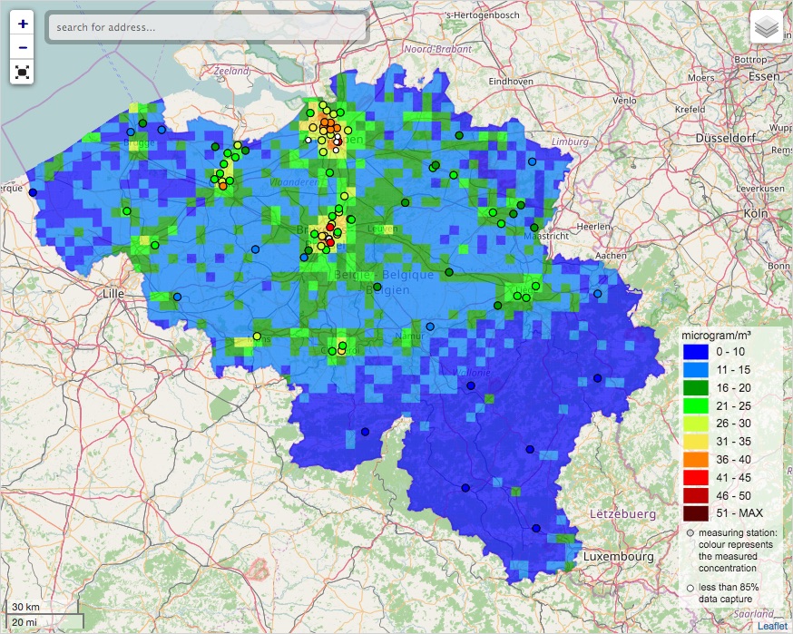
INSPIRE compliant download service for geographic information made available by the Belgian Interregional Environment Agency (IRCEL - CELINE).
-

INSPIRE compliant view service for geographic information of general marine datasets made available by the Royal Belgian Institute for Natural Sciences (RBINS). More specific products such as the Marine Spatial Plan and the MSFD data are provided by other WMS services.
-

This webservice allows viewing a digital surface model. It is a homogeneous and regular points grid which indicates the height above the surface of the earth, either the soil or any other permanent and visible element in the landscape (vegetation, construction,…). These data represent the situation of the landscape resulting from the July 2021 floods in het areas of the Vesdre, of part of the Meuse downstream from Liège and of the Demer. The heights are given relative to the Belgian zero level (fictitious zero of Uccle). The data have a resolution (size of the meshes of the regular grid) of 20 cm.
-

This web service allows viewing the Belgian topographical vector data as established by the National Geographic Institute. It gives an overview of the data sets of the Top10Vector-series which can be purchased.
-

Govroam is a " wifi roaming " solution. This service offers to the users a simple and secure access to the wireless network of their institution, but also to networks of other participating institutions. A user from an organization that participates in govroam will be able to connect to any wireless access point broadcasting govroam. The data provided here makes it possible to locate these access points.
-

The Solar Ultraviolet - Visible Irradiance Monitoring network (SUVIM) is formed of observation stations operated by the Royal Belgian Institute for Space Aeronomy (IASB-BIRA). At each station, UV solar radiation is measured by several instruments. The network produces UV indices, solar irradiances and ancillary measurements such as meteorological conditions at the stations in quasi-real time. The SUVIM Station Network dataset includes information on the stations. It does not include the measured data, which form the SUVIM Observations dataset.
-
Web service with currently available electronic terrain and obstacle data in Area 1 related to: - Implementing Regulation (EU) No 2017/373 on, inter alia, the common requirements for air navigation service providers, as subsequently amended; - Annex 15 to the Chicago Convention on International Civil Aviation; - ICAO document 10066 PANS-AIM: Procedures for air navigation services, Aeronautical Information Management.
-

This web service allows viewing datasets from Buildings
-

Mapindex is a WMS which allows viewing the regular index grid which has been defined on five levels for the entire Belgian territory. It has been defined in order to allow a zonal geolocation. The present version is a beta version (v2) which is submitted to the emergency services. It will evolve to a standard cartographic grid.