 geo.be Metadata Catalog
infoMapAccessService
Type of resources
Available actions
INSPIRE themes
federalThemes
Keywords
Contact for the resource
Provided by
Years
Formats
Update frequencies
Service types
-

-
View Service (WMS) for Lidar over Belgium The data are updated regularly. Only the archives of the last two months are available.
-
View Service (WMS) for Synoptic observations
-

This web service allows viewing the dataset BeStAddress.
-
View Service (WMS) for Alaro over Belgium. All the parameters of the last run of Alaro can be visualized, most of them associated with a custom style.
-

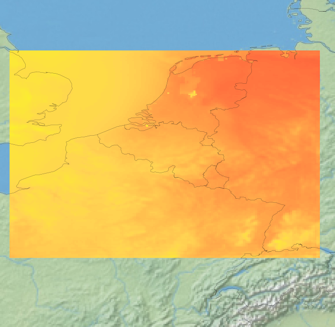
This webservice allows viewing a digital surface model. It is a homogeneous and regular points grid which indicates the height above the surface of the earth, either the soil or any other permanent and visible element in the landscape (vegetation, construction,…). These data represent the situation of the landscape resulting from the July 2021 floods in het areas of the Vesdre, of part of the Meuse downstream from Liège and of the Demer. The heights are given relative to the Belgian zero level (fictitious zero of Uccle). The data have a resolution (size of the meshes of the regular grid) of 20 cm.
-

This web service allows downloading datasets from CORINE Land Cover-2018-Belgium, compliant with the INSPIRE data specifications
-

This web service allows viewing the datasets under the Marine Strategy Framework Directive (MSFD).
-

Mapindex is a WMS which allows viewing the regular index grid which has been defined on five levels for the entire Belgian territory. It has been defined in order to allow a zonal geolocation. The present version is a beta version (v2) which is submitted to the emergency services. It will evolve to a standard cartographic grid.
-

Govroam is a " wifi roaming " solution. This service offers to the users a simple and secure access to the wireless network of their institution, but also to networks of other participating institutions. A user from an organization that participates in govroam will be able to connect to any wireless access point broadcasting govroam. The data provided here makes it possible to locate these access points.