 geo.be Metadata Catalog
2015
Type of resources
Available actions
Topics
INSPIRE themes
federalThemes
Keywords
Contact for the resource
Provided by
Years
Formats
Representation types
Update frequencies
status
Service types
Scale
-

CadGIS Viewer is an application developed by the General Administration of Patrimonial Documentation of the FPS Finance. This application allows to: - consult the current situation of the land register plan and the administrative units and print them out; - consult all the tax situations since 2018 (situation as on 1 January) for the land register plan and administrative units; - search and geolocate the objects on the land register plan on the basis of space characteristics or queries; - ask for and print out cadastral plan parcels within a certain range around or adjacent to one or more parcels ; - search graphically on the map for surveyors' plans (only for surveyors); - add additional data to the map, both from a predefined list (IGN - Belgian national geographical institute’s aerial photographs, Cartoweb, regional reference frames such as GRB and PICC, ...) as well as other data via the URL of web services.
-

This web service provides a display of the Administrative Units - INSPIRE datase This webservice complies with the INSPIRE specifications.
-
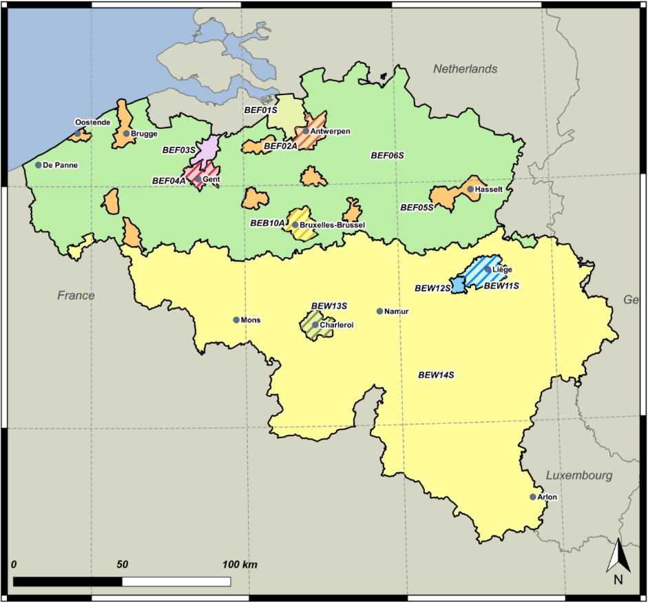
The zones are used as reporting units of the air quality in Belgium. These zones are defined based on Article 3 of the 2004/107/EC Directive and Article 4 of the 2008/50/EC Directive. A zones shall mean a part of the territory of a Member State, as delimited by that Member State for the purposes of air quality assessment and management (source: 2008/50/EC).2008/50/EC Article 4: Establishment of zones and agglomerations: Member States shall establish zones and agglomerations throughout their territory. Air quality assessment and air quality management shall be carried out in all zones and agglomerations.
-

Natura 2000 (N2K) is a network of core breeding and resting sites for rare and threatened species, as well as for some rare natural habitat types which are protected in their own right. It stretches across all 28 EU countries, both on land and at sea. The aim of the network is to ensure the long-term survival of Europe's most valuable and threatened species and habitats that are listed under the Birds Directive and the Habitats Directive. This dataset contains the sites in Belgium.
-
Administrative Units - INSPIRE corresponds to the dataset of the Belgian administrative units that complies with the INSPIRE specifications. This dataset is composed of two classes. The first class contains administrative units and the second class contains administrative boundaries. The class are composed of the following administrative level: Kingdom, Regions, Provinces, and arrondissements, and municipalities. The entire dataset can be downloaded via the ad hoc WFS.
-
This web service provides a download per object of the Administrative Units -INSPIRE dataset. This webservice complies with the INSPIRE specifications.
-

This web service provides a display of the dataset Cadastral parcels - INSPIRE. This webservice complies with the INSPIRE specifications and is available in several formats. It is recommended to use the PNG format.
-
This web service provides a download per object of the dataset Cadastral parcels - INSPIRE. . This webservice complies with the INSPIRE specifications.