 geo.be Metadata Catalog
GML
Type of resources
Available actions
Topics
INSPIRE themes
federalThemes
Keywords
Contact for the resource
Provided by
Years
Formats
Representation types
Update frequencies
status
Service types
Scale
Resolution
-
The layer Geographical Names includes all the names of administrative units, uninhabited places, waterways, remarkable buildings and infrastructures. They are classified into different feature and attribute classes.
-

The entities included in the dataset represent the physical network in the sense of the Inspire European directive. The dataset comprises several classes and is in accordance with the INSPIRE specifications. The Wetland class represents poorly drained or periodically flooded portions of land, the soil of which is saturated with water but where vegetation is nevertheless able to develop. The StandingWater class represents flooded areas that are, nevertheless, completely surrounded by land.
-

Landuse-Particular Zone is the INSPIRE 2D vector data set of the "Particular zones" layer originated from the Top10vector product of the National Geographic Institute in Belgium . It includes the "ExistingLandUseDataSet" features and the "ExistingLandUseObject" features in accordance with the INSPIRE specifications.
-
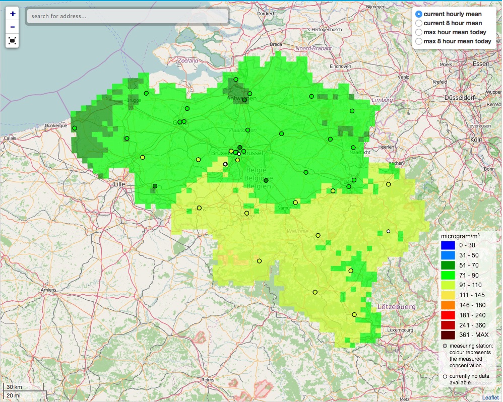
The air quality monitoring networks in Belgium are used for the assessment of air quality under the air quality directives (2008/50/EC & 2004/107/EC).
-

Cadastral Parcels - INSPIRE corresponds to the dataset of Belgian plan cadastral parcels complying with INSPIRE specifications. This dataset is composed of two classes. The first class contains cadastral zoning and the second class contains cadastral parcel. The entire dataset can be downloaded via the ad hoc WFS.
-

Electricity network is the INSPIRE vector data set originated from the High-Tension network of the product TOP10Vector of the National Geographic Institute in Belgium. The Electricity network is regularly updated with the ELIA Group data sources. It includes the "ElectricityCable" features and the "Pole" features in accordance with the INSPIRE specifications.
-

The entities included in dataset represent the Belgian waterway transport network in the sense of the Inspire European directive. The dataset comprises several classes and is in accordance with the INSPIRE specifications. The class represents, in a linear manner, all of the waterway links between each pair of dots for the network considered. In addition to this is one class without geometry. The RestrictionForWaterCehicles class specifies for each segment the maximum tonnage of the building using the segment.
-
This web service provides a download per object of the dataset Cadastral parcels - INSPIRE. . This webservice complies with the INSPIRE specifications.
-

Buildings is the INSPIRE 2D vector data set of the "Constructions" layer originated from the Top10vector product of the National Geographic Institute in Belgium . It includes the "Building" features and the "OtherConstruction" features in accordance with the INSPIRE specifications.
-

The data set contains a seamless polygonal layer representing the land cover in Belgium for the year 2018. The dataset is INSPIRE compliant.