 geo.be Metadata Catalog
CSV
Type of resources
Available actions
Topics
INSPIRE themes
federalThemes
Keywords
Contact for the resource
Provided by
Years
Formats
Representation types
Update frequencies
status
Service types
Scale
-

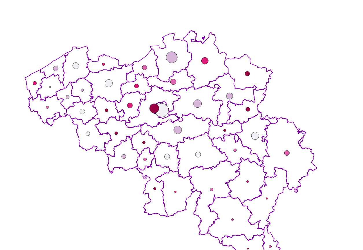
Distribution of real estate assets - Legal persons corresponds to the dataset relating to the distribution of real estate assets owned by legal entities such as recorded by the FPS Finance for tax purposes. This dataset is composed of eight classes. The first class mentions, at national level, for each cadastral income bracket, the number of legal persons grouped together by economic activity with real estate capital valued in the relevant bracket as well as the total and median cadastral income of the parcels held by these entities. The assessment of the cadastral income takes into account the shares actually held. The second class includes this information at the level of the three regions. The following classes do the same at the level of provinces, districts, municipalities, land register divisions and statistical sectors. The last class includes this information at the level of the countries for the legal entities which are not settled in Belgium but wich are nevertheless reigstred at the Carrefour Banque of the Entreprises. The dataset can be freely downloaded as a zipped CSV.
-

Share of the cadastral surface area that is not artificially developed in the cadastral and not unknown surface area to the administrative entity (region, province, district and municipality) for Wallonia
-
The number of private households according to official statistics, per administrative unit (region, province, district and municipality) for Wallonia.
-
The average household size of private households by administrative unit (region, province, district and municipality) for Wallonia.
-
Settlement area is defined here in terms of land use. Settelement area is the space occupy to live, work, relax and move around. This includes everything that seals the soil but also includes various forms of non-paved green space, such as gardens and parks or sports grounds and these are therefore not counted as open space. These indicators show the total settelement area expressed in m² and the part of the settlement area in relation to the total area per administrative entity (region, province, district and municipality) for Flanders.
-
Characteristics of the cadastral parcels - Land use corresponds to the dataset describing the cadastral nature of the parcels such as recorded by the FPS Finance for tax purposes. This dataset is composed of seven classes. The first class shows, at the national level, for each type, the number of parcels, their cadastral income and their total surface area, as well as the median cadastral income of the plots. The second class includes this information at the level of the three regions. The following classes do the same at the level of provinces, arrondissements, municipalities, cadastral divisions and statistical sectors. The dataset can be freely downloaded as a zipped CSV.
-

Characteristics of the cadastral parcels - Exemption from withholding tax on immovable property corresponds to the dataset describing the parcels exempted from withholding tax on immovable property. The first class shows, at the national level, the number of parcels per exemption category, the total amount of cadastral income of these parcels, their surface area as well as the median cadastral income of each category. The second class includes this information at the level of the three regions. The following classes do the same at the level of provinces, arrondissements, municipalities, cadastral divisions and statistical sectors. The dataset can be freely downloaded as a zipped CSV.
-

Characteristics of the cadastral parcels - Rights of real estate companies corresponds to the dataset describing the legal persons holding real rights on the parcels such as recorded by the FPS Finance for registration purposes. This dataset is composed of seven classes. The first class shows, at the national level, for each cadastral nature and for each type of real right, the number of parcels, their total cadastral income, as well as for each category of economic activity, the number of parcels on which real estate companies hold the concerned real rights (i.e. the companies of L class from NACE classification). The second class includes this information at the level of the three regions. The following classes do the same at the level of provinces, arrondissements, municipalities, cadastral divisions and statistical sectors. The dataset can be freely downloaded as a zipped CSV.
-
Hourly warnings of dangerous meteorological phenomena (wind, rain, ice or snow, fog, storm surge, thunderstorm) issued by the RMI, based on the estimated impact. This product is not publically available yet.
-

Real estate leases corresponds to the dataset describing leases on real estate items as recorded for registration purposes by the FPS Finance. This dataset is composed of seven classes. The first class shows, at the national level, for each type of lease within the meaning of the Code of Registration Duties, the number of leases taking effects during the term, the nature of the parties concerned by the contract and the median rent and expenses and the percentiles 25 and 75 of the rent and expenses of the properties concerned. The second class includes this information at the level of the three regions. The following classes do the same at the level of provinces, arrondissements, municipalities, cadastral divisions and statistical sectors. The dataset can be freely downloaded as a zipped CSV.